
Tunbridge is a town in Orange County, Vermont, United States. As of the 2020 United States Census the town population was 1,337. The town consists of three village centers, all situated on Vermont Route 110 in the valley of the first branch of the White River. The three settlements are named North Tunbridge, Tunbridge Village ("Market") and South Tunbridge ("Jigger").

West Hartford is an unincorporated community village in the town of Hartford, Windsor County, Vermont. It is the most rural of Hartford's five villages, situated on the White River and crossed by the Appalachian Trail.

The Waterville Village Historic District encompasses most of the history 19th and early 20th-century village center of Waterville, Vermont. The village grew from beginnings late in the 18th century to serve as a modest civic, commercial, and residential hub for the rural community. It was added to the National Register of Historic Places in 2007.

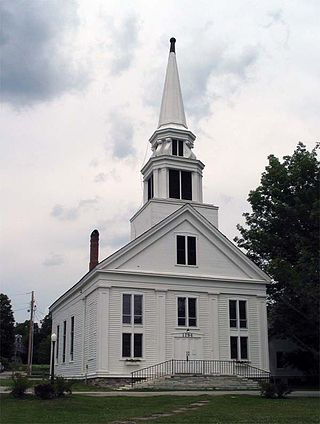
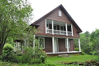
The South Tunbridge Methodist Episcopal Church is a historic church on Vermont Route 110, about one-third of a mile north of the Royalton town line in Tunbridge, Vermont. Built in 1833, it is one of the finest examples of late Federal period architecture in Orange County, and was a mainstay of social and civic life in southern Tunbridge for many years. It was listed on the National Register of Historic Places in 2001.

The Grafton Village Historic District encompasses the historic village center of the town of Grafton, Vermont. The village was developed in the early-to-mid 19th century, and has retained the character of that period better than many small communities in the state. The district was listed on the National Register of Historic Places in 2010.

The Rockingham Village Historic District encompasses the traditional village center of the town of Rockingham, Vermont. Settled in the 18th century, the district, located mainly on Meeting House Road off Vermont Route 103, includes a variety of 18th and 19th-century houses, and has been little altered since a fire in 1908. It notably includes the 18th-century National Historic Landmark Rockingham Meeting House. The district was listed on the National Register of Historic Places in 2008.

The East Arlington Village Historic District encompasses the historic core of a 19th-century village in Arlington and Sunderland, Vermont, United States. It is centered on Old Mill Road, and developed as a mill village beginning in the 18th century. It was listed on the National Register of Historic Places in 1996.
The Middletown Springs Historic District encompasses most of the village center of Middletown Springs, Vermont. Oriented around the crossroads junction of Vermont Routes 140 and 133, the village has a well-preserved collection of mainly mid-19th century architecture, including a significant number of Italianate buildings. The district was listed on the National Register of Historic Places in 1985.
The Tinmouth Historic District encompasses a cluster of residential and civic buildings that form the center of the village Tinmouth Center in Tinmouth, Vermont. The district contains a collection of well-preserved buildings, that are reflective of life in a rural 19th-century village. The district was listed on the National Register of Historic Places in 1980.

The Bethel Village Historic District encompasses the historic core of the village of Bethel in the town of Bethel, Vermont, USA. The L-shaped district extends along Main and Church Streets, including many of the village's commercial and civic buildings, as well as a significant number of 19th and early 20th-century residences. The district was listed on the National Register of Historic Places in 1976, and was slightly enlarged in 1990.

The Chester Village Historic District encompasses the historic southern portion of the main village of Chester, Vermont, US. Essentially a linear stretch of Main Street, this area includes some of the village's oldest buildings and has an architectural history spanning into the early 20th century. The district was listed on the National Register of Historic Places in 1985.
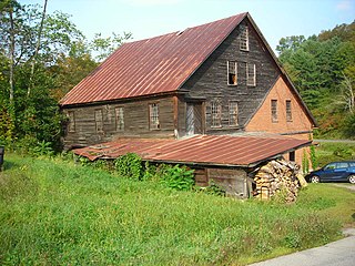
The Hayward and Kibby Mill, also known as the Tunbridge Mill, is a historic industrial facility on Spring Road in Tunbridge, Vermont. It includes a substantially complete water-powered 19th-century grist mill dating back to 1820, with a later sawmill added about 1870. It is one of the few surviving water-powered mills in the state, and is believed to be the only one featuring both a sawmill and grist (grain) mill. It was listed on the National Register of Historic Places in 1992.

The South Royalton Historic District encompasses the central portion of the village of South Royalton, Vermont. Now the town of Royalton's principal commercial center, it developed in the second half of the 19th century around the depot of the Vermont Central Railroad. The district includes fine examples of Greek Revival and Victorian architecture, and is home to the Vermont Law School. It was listed on the National Register of Historic Places in 1976.

The Mill Covered Bridge is a replica historic covered bridge carrying Spring Road across the First Branch White River in Tunbridge, Vermont. It was built in 2000, nearly replicating a previous structure built on the site in 1883 and lost due to ice damage. It is one of a high concentration of covered bridges in Tunbridge and Chelsea. The 1883 bridge was listed on the National Register of Historic Places in 1974.

The Downtown Essex Junction Commercial Historic District encompasses the historically railroad-dominated portion of downtown Essex Junction, Vermont. Aligned along the south side of Railroad Avenue and adjacent portions of Main Street, the area underwent most of its development between 1900 and 1940, when Essex Junction served as a major regional railroad hub. The district was listed on the National Register of Historic Places in 2004.
The Jericho Village Historic District encompasses the historic industrial and commercial center of the village of Jericho, Vermont. Stretched along Vermont Route 15 south of Browns River, which powered the village's industries for many years, the village center includes a well-preserved array of 19th and early 20th-century buildings. The district was listed on the National Register of Historic Places in 1992.
The North Calais Village Historic District encompasses a linear 19th-century mill village in Calais, Vermont. It extends mainly along North Calais Road, paralleling Pekin Brook below Mirror Lake, where ruins of its former industrial past are still evident. It was listed on the National Register of Historic Places in 2010.

The Waitsfield Village Historic District encompasses much of the main village center of Waitsfield, Vermont. Extending along Vermont Route 100 on either side of Bridge Street, it is a well-preserved example of a 19th-century village, with only a few sympathetic 20th-century additions. It was listed on the National Register of Historic Places in 1983.

The Waterbury Village Historic District encompasses most of the central commercial and residential area of Waterbury, Vermont. Located along United States Route 2 and Stowe Street south of Thatcher Branch of the Winooski River, the sprawling village has been shaped by changes in transportation in the 19th and 20th centuries, and by key economic developments such as the founding of the Vermont State Hospital, which anchors the village's southern end. The district was listed on the National Register of Historic Places in 1978.
The Rupert Village Historic District encompasses the 19th-century village center of Rupert, Vermont. Extending along Vermont Route 153 and adjacent roads, the village preserves a 19th-century landscape and a variety of structures important in the life and economy of the period. The district was listed on the National Register of Historic Places in 2022.


