
Newbury is an incorporated village in the town of Newbury in Orange County, Vermont, United States. The population was 447 at the 2020 census.
The John Adams Homestead/Wellscroft is a historic farmstead off West Sunset Hill Road in Harrisville, New Hampshire. The oldest portion of the farm's main house is a 1+1⁄2-story wood-frame structure built in the 1770s. It is one of the least-altered examples of early Cape style architecture in Harrisville, lacking typical alterations such as the additions of dormers and changes to the window sizes, locations, and shapes. The farmstead, including outbuildings and an area of roughly 2 acres (0.81 ha) distinct from the larger farm property, was listed on the National Register of Historic Places.

Elm Farm, alsk known as the Sargent Farm, is a historic farm property at 599 Main Street in Danville, New Hampshire. Established about 1835, it has been in agricultural use since then, with many of its owners also engaged in small commercial or industrial pursuits on the side. The main farmhouse is one of the town's best examples of Gothic Revival architecture. The property was listed on the National Register of Historic Places in 1988.
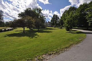
The Dickinson Estate Historic District encompasses the core holding of an early 20th century country estate in rural northern Brattleboro, Vermont. It includes a sophisticated Colonial Revival mansion house, built in 1900, and a variety of agricultural outbuildings dating to the same period. The estate, and in particular its barnyard complex, are well-preserved remnants of this era. The property is also notable for its association with Rudyard Kipling, who owned the estate for several years. It was listed on the National Register of Historic Places in 2005. The district covers 30 acres (12 ha) of what is now the main campus of the World Learning organization, a larger subset of the original Dickinson Estate.

The Parker Hill Rural Historic District encompasses a large rural agricultural landscape in eastern Windham and Windsor counties in the US state of Vermont. Roughly centered on Parker Hill Road in northern Rockingham and southern Springfield, the district exhibits a history of 200 years of farming, including a collection of Federal period farm housing. The district was listed on the National Register of Historic Places in 1993.
West Townshend is an unincorporated village in Townshend, Vermont, United States. It is on the north side of a bend in the West River, upriver of the Townshend Dam. The entire village is listed on the National Register of Historic Places as the West Townshend Village Historic District. Its ZIP codes are 05359 and 05353.
The Rural Otter Creek Valley Historic District encompasses a rural agricultural area of southern Wallingford, Vermont. It includes nine past and present farmsteads along a stretch of United States Route 7 in the Otter Creek valley, with an agricultural history dating to the early decades of the 19th century. The district was listed on the National Register of Historic Places in 1987.
The Christian Street Rural Historic District encompasses the surviving elements of an early settlement village in the town of Hartford, Vermont. Centered on the junction of Christian Street and Jericho Street in northeastern Hartford, the area includes a modest number of 18th and 19th-century houses, as well as two farms that have been in the same families since the 18th century. The district was listed on the National Register of Historic Places in 2003.
The Jericho Rural Historic District encompasses a rural agricultural landscape of northern Hartford, Vermont, extending slightly into neighboring Norwich. The area covers 774 acres (313 ha) of mainly agricultural and formerly agricultural lands, as well as associated woodlots, and includes nine historically significant farm complexes. It was listed on the National Register of Historic Places in 2001.

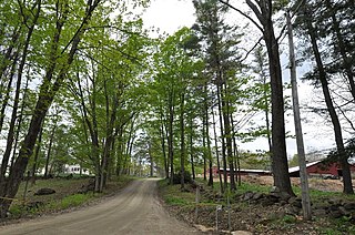
The Bayley Historic District encompasses a small cluster of buildings in Newbury, Vermont, a number of which are associated with the historically prominent Bayley family. It includes some of the town's oldest buildings, and is where the founder of the town, Jacob Bayley, first settled and later died. The district is oriented along Oxbow Road west of United States Route 5 and north of the town's main village. It was listed on the National Register of Historic Places in 1983.

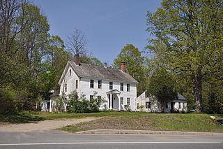
The Gen. Lewis R. Morris House is a historic house and farm property at 456 Old Connecticut River Road in Springfield, Vermont. Its main house, built in 1795, is well-preserved local example of Federal architecture with later Greek Revival features. The property also includes well-preserved 19th-century agricultural buildings, and was listed on the National Register of Historic Places in 1992.

The South Newbury Village Historic District encompasses the surviving elements of a small industrial village in southern Newbury, Vermont. It includes five residences and several outbuildings, most of which are agricultural in character, representing the area's shift in use in the 20th century. The district was listed on the National Register of Historic Places in 1983.

The Weston Village Historic District encompasses the town center and principal village of Weston, Vermont. Centered on Farrar Park, which serves as the town green, it includes a diversity of architectural styles from the late 18th century to about 1935, and includes residential, civic, commercial, industrial and religious buildings. It was listed on the National Register of Historic Places in 1985.
The Colonel Ephraim and Sarah Doolittle Farm is a historic farm property on Doolittle Road in Shoreham, Vermont. It is one of the oldest colonial farm properties in western Vermont, established in 1766 by Colonel Ephraim Doolittle, a veteran of the French and Indian War and the American Revolutionary War. It was listed on the National Register of Historic Places in 1995.

The West Newbury Village Historic District encompasses the modest rural country village of West Newbury, Vermont. It is located at the junction of Tucker Mountain, Snake, and Tyler Farm Roads, and is relatively little altered since its 19th-century development. It was listed on the National Register of Historic Places in 1983.

The Warren Village Historic District encompasses the village center of Warren, Vermont, United States. Stretched mainly along Main Street east of the Mad River, it is a well-preserved 19th-century mill village, although most of its period mill infrastructure has been lost. The district has good examples of Greek Revival, Italianate, and Second Empire architecture. It was listed on the National Register of Historic Places in 1992.

The Shelburne Village Historic District encompasses the central portion of the main village of Shelburne, Vermont. Centered on the junction of United States Route 7 with Harbor and Falls Roads, the district's architecture traces the town's history from the 18th to early 20th century. It was listed on the National Register of Historic Places in 1990.
The William and Agnes Gilkerson Farm, also known more recently as the Kitchel Hill Farm, is a historic farmstead on Kitchel Hill Road in Barnet, Vermont. Established in the late 18th century by Scottish immigrants, it includes one of the finest known examples of a rubblestone farmhouse in the region. The property was listed on the National Register of Historic Places in 1992.

Lee Farm is a historic farm property on Vermont Route 18 in Waterford, Vermont. Established in 1801, it was for many years worked by members of the Lee family, and part of a thriving rural community called Waterford Hollow. Its farmstead features surviving 19th and early 20th-century outbuildings and a high-quality Greek Revival farmhouse. A 5-acre (2.0 ha) portion of the farm, encompassing the farmstead, was listed on the National Register of Historic Places in 1983.
The Goodrich Four Corners Historic District encompasses a rural 19th-century village center in rural northern Norwich, Vermont. The village arose in the late 18th century, settled by the son of one of Norwich's early proprietors. The district has well-preserved examples of architecture ranging from the late 18th century to the early 20th century. It was listed on the National Register of Historic Places in 2019.


