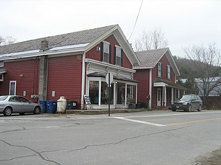
Wells River is a village in the town of Newbury in Orange County, Vermont, United States. The population was 431 at the 2020 census. The village center is located at the junction of U.S. Routes 5 and 302.

Newbury is an incorporated village in the town of Newbury in Orange County, Vermont, United States. The population was 447 at the 2020 census.

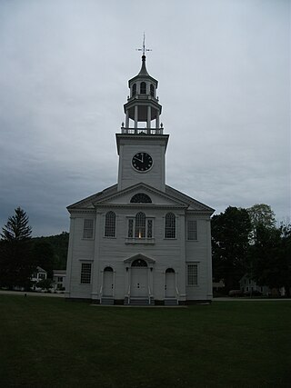
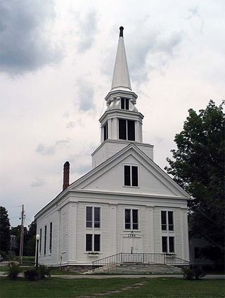
Newbury is a town in Orange County, Vermont, United States. The population was 2,293 at the 2020 census. Newbury includes the villages of Newbury, Center Newbury, West Newbury, South Newbury, Boltonville, Peach Four Corners, and Wells River.

The Clinton Village Historic District encompasses the historic portion of the town center of Clinton, Connecticut. It is roughly linear and extends along East Main Street from the Indian River in the west to Old Post Road in the east. The area represents a well-preserved mid-19th century town center, with architecture dating from the late 17th to mid-20th centuries. The district was listed on the National Register of Historic Places in 1994.

The Norwich Village Historic District encompasses the compact village center of Norwich, Vermont. The village was developed mainly in the first half of the 19th century, benefiting in importance from the 1820 founding of what is now Norwich University. The district has well-preserved examples of architecture ranging from the late 18th century to the early 20th century. It was listed on the National Register of Historic Places in 1991.

The New Preston Hill Historic District encompasses a small rural 19th-century village center in the New Preston area of the town of Washington, in Litchfield County, Connecticut. Settled in the late 18th century, it is distinctive for its examples of stone architecture, include a rare Federal period stone church. The district, located at the junction of New Preston Road with Gunn Hill and Findlay Roads, was listed on the National Register of Historic Places in 1985.

The Rockingham Village Historic District encompasses the traditional village center of the town of Rockingham, Vermont. Settled in the 18th century, the district, located mainly on Meeting House Road off Vermont Route 103, includes a variety of 18th and 19th-century houses, and has been little altered since a fire in 1908. It notably includes the 18th-century National Historic Landmark Rockingham Meeting House. The district was listed on the National Register of Historic Places in 2008.
The East Poultney Historic District encompasses the historic center of the rural village of East Poultney, Vermont. The district is centered on the triangular green at the center of the village, and was developed mainly from the late 18th through mid-19th centuries, producing a village with strong Federal and Greek Revival architecture. It was listed on the National Register of Historic Places in 1978.
The Middletown Springs Historic District encompasses most of the village center of Middletown Springs, Vermont. Oriented around the crossroads junction of Vermont Routes 140 and 133, the village has a well-preserved collection of mainly mid-19th century architecture, including a significant number of Italianate buildings. The district was listed on the National Register of Historic Places in 1985.

The Bethel Village Historic District encompasses the historic core of the village of Bethel in the town of Bethel, Vermont, USA. The L-shaped district extends along Main and Church Streets, including many of the village's commercial and civic buildings, as well as a significant number of 19th and early 20th-century residences. The district was listed on the National Register of Historic Places in 1976, and was slightly enlarged in 1990.
The Jericho Rural Historic District encompasses a rural agricultural landscape of northern Hartford, Vermont, extending slightly into neighboring Norwich. The area covers 774 acres (313 ha) of mainly agricultural and formerly agricultural lands, as well as associated woodlots, and includes nine historically significant farm complexes. It was listed on the National Register of Historic Places in 2001.

The Oxbow Historic District encompasses a well-preserved rural agricultural area on United States Route 5 in northern Newbury, Vermont. It was one of the first areas to be settled in the town, and includes seven agricultural properties, with six farmhouses built before 1835 and a number of surviving 19th-century farm outbuildings. It was listed on the National Register of Historic Places in 1983.

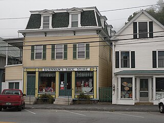
The South Newbury Village Historic District encompasses the surviving elements of a small industrial village in southern Newbury, Vermont. It includes five residences and several outbuildings, most of which are agricultural in character, representing the area's shift in use in the 20th century. The district was listed on the National Register of Historic Places in 1983.

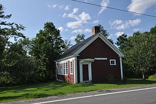
The West Newbury Village Historic District encompasses the modest rural country village of West Newbury, Vermont. It is located at the junction of Tucker Mountain, Snake, and Tyler Farm Roads, and is relatively little altered since its 19th-century development. It was listed on the National Register of Historic Places in 1983.
The Charlotte Center Historic District encompasses the historic 19th-century town center of Charlotte, Vermont. Settled c. 1790 and developed mainly in the mid-19th century, the village, stretched along Church Hill Road west of Hinesburg Road, retains a well-preserved 19th-century atmosphere of residential, civic, and commercial buildings. The district was listed on the National Register of Historic Places in 1984.

The Kents Corner Historic District encompasses a well-preserved 19th-century crossroads hamlet in Calais, Vermont. Centered on the junction of Kent Hill Road, Old West Church Road, and Robinson Cemetery Road, it developed as a stagecoach stop with a small industrial presence. It was listed on the National Register of Historic Places in 1973, and substantially enlarged in 2006.
The Waitsfield Common Historic District encompasses the original town center settlement of Waitsfield, Vermont, at the junction of Joslin Hill, Common, East, and North Roads. Located about 1 mile (1.6 km) from the town's present main village and center, it was laid out in 1793, and includes the triangular town common, a cemetery, and a number of houses built mainly between 1793 and 1841. The district was listed on the National Register of Historic Places in 2001.

The Stowe Village Historic District encompasses most of the village center of Stowe, Vermont. The village has since the 19th century been one of Vermont's major resort centers, and its center is architecturally reflective of this history, It was listed on the National Register of Historic Places in 1978.

The Peacham Corner Historic District encompasses much of the historic village center of Peacham, Vermont. The village's period of greatest growth and importance between the town's founding as a hill town in the late 18th century, and 1860, when significant development effectively ended. As a result, the village lacks Victorian features often found in other rural communities. The district was listed on the National Register of Historic Places in 2003.
Jacob Bayley was an officer, first serving with the British in the French and Indian War, then later as a brigadier general in the Continental Army during the American Revolutionary War.


