
Tweed Heads is a coastal city at the mouth of the Tweed River in the Northern Rivers region of the state of New South Wales, Australia. Tweed Heads is the northernmost town in New South Wales, and is located in the Tweed Shire local government area. It is situated 830 km (520 mi) north of Sydney and 103 km (64 mi) south of Brisbane. The town is next to the border with Queensland and is adjacent to its "twin town" of Coolangatta, which is a suburb of the Gold Coast in Queensland.

Uki is a village situated near Mount Warning in the Tweed Valley of far northern New South Wales, Australia in the Tweed Shire. At the 2011 census, Uki had a population of 765 people. Its name may have come from an aboriginal word for "small water plant with a yellow flower and edible root". The name UKI was actually derived from the limber mills in the area. Prime timber for export was marked UK 1, as in timber destined for the United Kingdom - grade 1. Hence UK1, which colloquially named the township UKI.

Kingscliff is a coastal town just south of Tweed Heads in the Northern Rivers region of New South Wales, Australia, and is a beach community offering a variety of holiday accommodations. Together with the villages of Chinderah and Fingal, it is a tourist destination that provides beach and estuary access for swimming, surfing, fishing and water sports.

Tweed Shire is a local government area located in the Northern Rivers region of New South Wales, Australia. It is adjacent to the border with Queensland, where that meets the Coral Sea. Administered from the town of Murwillumbah, Tweed Shire covers an area of 1,321 square kilometres (510 sq mi), and has existed as a local government entity since 1947. It was named for the Tweed River.
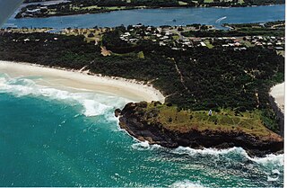
Fingal Head is a village on the Tasman Sea coast in the far northeast of New South Wales, Australia, about 5 km south of the New South Wales and Queensland border. The village is often just called Fingal. The headland and the small off-shore Island were first sighted by James Cook about 17:00 on 16 May 1770. At the time of the 2021 census, Fingal Head had a population of 592 people.
Chinderah is a town in the Tweed Shire. It is located south of Tweed Heads and next to the seaside township of Kingscliff. An industrial estate, golf course and small shopping precinct are located within the area.

Tweed Heads West is a suburb of Tweed Heads, located on the Tweed River in north-eastern New South Wales, Australia, in Tweed Shire along the Queensland and New South Wales border.
Bilambil is a town located in north-eastern New South Wales, Australia, in the Tweed Shire.
Casuarina is a town located in north-eastern New South Wales, Australia, in the Tweed Shire.
Cudgen is a town located in north-eastern New South Wales, Australia, in the Tweed Shire. It is built on the former land of the Coodjingburra clan of the Minyungbal. There is a primary school on Collier Street, the Cudgen Public School.

Hastings Point is a town located in north-eastern New South Wales, Australia, in the Tweed Shire. From 1947 to 1962 aerial photography revealed foredunes up to 16 metres high in the area that had reduced to six to nine metres high by 1977.
Bray Park is a suburb of Murwillumbah located in north-eastern New South Wales, Australia, in the Tweed Shire.
South Murwillumbah is a locality located in north-eastern New South Wales, Australia, in the Tweed Shire.
Carool is a town located in the Tweed Shire in north-eastern New South Wales, Australia.

Clothiers Creek is a town located in north-eastern New South Wales, Australia, in the Tweed Shire.
Dunbible is a town located in north-eastern New South Wales, Australia, in the Tweed Shire and it is on the lands of the Bundjalung people.
Dungay is a town located in north-eastern New South Wales, Australia, in the Tweed Shire.
Eungella is a town located in north-eastern New South Wales, Australia, in the Tweed Shire. It is located on the Oxley River and on the Tyalgum Road from Murwillumbah to Tyalgum.

Mount Burrell is a town and a mountain in the Nightcap Range in the Tweed Shire in the Northern Rivers region of New South Wales, Australia.
Pumpenbil is a town located in north-eastern New South Wales, Australia, in the Tweed Shire.


