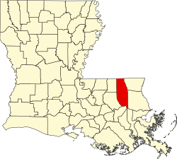
Uneedus, Louisiana

Last updated

Uneedus, Louisiana
USA Louisiana location map.svg
Red pog.svg
Uneedus, Louisiana
Usa edcp location map.svg
Red pog.svg
Uneedus, Louisiana
Coordinates: 30°37′03″N90°15′40″W / 30.61750°N 90.26111°W / 30.61750; -90.26111
Country United States
State Louisiana
Parish Tangipahoa
Elevation
29 ft (9 m)
Time zone UTC-6 (Central (CST))
  Summer (DST) UTC-5 (CDT)
Area code 985
GNIS feature ID543746 [1]
FIPS code 22-76980

Uneedus is an unincorporated community in Tangipahoa Parish, in the U.S. state of Louisiana. [2]

History

The community's name is derived from shortening and alteration of "You need us", [3] the motto of a local lumber company. [4] A post office called Uneedus was established in 1912, and remained in operation until 1928. [5]

Related Research Articles

<span class="mw-page-title-main">Tangipahoa Parish, Louisiana</span> Parish in Louisiana, United States

Tangipahoa Parish is a parish located on the southeastern border of the U.S. state of Louisiana. As of the 2020 census, the population was 133,157. The parish seat is Amite City, while the largest city is Hammond. Southeastern Louisiana University is located in Hammond. Lake Pontchartrain borders the southeastern side of the parish.

<span class="mw-page-title-main">St. Tammany Parish, Louisiana</span> Parish in Louisiana, United States

St. Tammany Parish is a parish located in the U.S. state of Louisiana named after Tamanend, the legendary Lenape Chief of Chiefs and the "Patron Saint of America." At the 2020 census, the population was 264,570, making it the fourth-most populous parish in Louisiana. The parish seat is Covington. The parish was founded in 1810.

<span class="mw-page-title-main">Hammond, Louisiana</span> City in Louisiana, US

Hammond is the largest city in Tangipahoa Parish, Louisiana, United States, located 45 miles (72 km) east of Baton Rouge and 45 miles (72 km) northwest of New Orleans. Its population was 20,019 in the 2010 U.S. census, and 21,359 at the 2020 population estimates program.

<span class="mw-page-title-main">Independence, Louisiana</span> Town in Louisiana, United States

Independence, originally known as Uncle Sam, is a town in Tangipahoa Parish, Louisiana, United States. The population was 1,665 at the 2010 census. It is part of the Hammond Micropolitan Statistical Area.

<span class="mw-page-title-main">Tangipahoa River</span> River in Louisiana, United States

The Tangipahoa River originates northwest of McComb in southwest Mississippi, and runs south 122 miles (196 km) through Lake Tangipahoa in Percy Quin State Park before passing into southeast Louisiana. There it flows entirely in the eponymous Tangipahoa Parish until its mouth opens into the northwest region of Lake Pontchartrain.

<span class="mw-page-title-main">Baptist, Louisiana</span> Unincorporated community in Louisiana, United States

Baptist is an unincorporated community in Tangipahoa Parish, Louisiana, United States. Baptist is located on U.S. Route 190, west of Hammond.

Robert is an unincorporated community in Tangipahoa Parish, Louisiana, United States. It lies east of Hammond, at the intersection of US 190 and LA 445, from which it has a signed exit on Interstate 12. Robert is the largest settlement in Tangipahoa Parish's rural 8th ward.

Arcola is an unincorporated community in Tangipahoa Parish, Louisiana.

Bolivar is an unincorporated community in Tangipahoa Parish, Louisiana, United States.

<span class="mw-page-title-main">Pumpkin Center, Louisiana</span> Unincorporated community in Louisiana

Pumpkin Center is an unincorporated community in Tangipahoa Parish, Louisiana, United States. Pumpkin Center is located on U.S. Route 190, west of Hammond.

Bedico is an unincorporated community in Tangipahoa Parish, Louisiana, United States. Bedico is located on Highway 22, 13 mi (20.92 km) miles east of Hammond.

Greenlaw is an unincorporated community in Tangipahoa Parish, Louisiana, United States. The community is located 17 miles N of Amite City, Louisiana.

Kirkville is an unincorporated community in Tangipahoa Parish, Louisiana, United States. The community is located 1 mile S of Osyka, Mississippi and 18 miles N of Amite City, Louisiana

Lees Landing is an unincorporated community in Tangipahoa Parish, Louisiana, United States. The community is located 7 miles SE of Ponchatoula, Louisiana.

Lewiston is an unincorporated community in Tangipahoa Parish, Louisiana, United States. The community is located 15 miles N of Amite City, Louisiana.

Osceola is an unincorporated community in Tangipahoa Parish, Louisiana, United States. The community is located 16 miles NW of Covington, Louisiana.

Sharkey is an unincorporated community in Tangipahoa Parish, Louisiana, United States. The community is located 5 miles S of Ponchatoula, Louisiana.

Strader is an unincorporated community in Tangipahoa Parish, Louisiana, United States. The community is located 8 miles S of Ponchatoula, Louisiana.

Wadesboro is an unincorporated community in Tangipahoa Parish, Louisiana, United States. The community is located 2 miles southwest of Ponchatoula, Louisiana.

Magnolia, also known as Otts Mill, is an unincorporated community in Livingston Parish, Louisiana, United States. The community is located 5 miles northwest of Livingston and 2 miles west of Starns on Louisiana Highway 442 at the intersection with Louisiana Highway 1036.

References

  1. "US Board on Geographic Names". United States Geological Survey. October 25, 2007. Retrieved January 31, 2008.
  2. U.S. Geological Survey Geographic Names Information System: Uneedus, Louisiana
  3. "Uneedus, Tangipahoa Parish, Louisiana". USGenWeb Archives. Retrieved July 26, 2019.
  4. "The Oddest Named Town in Every State". The Active Times. April 19, 2018. Retrieved July 3, 2019.
  5. "Post Offices". Jim Forte Postal History. Retrieved July 3, 2019.