Upalika, Missouri

Last updated

Upalika in 1941 Towns and Cities- Abandoned - Missouri - DPLA - 6e05c2f0765856580f84e41e5c3fc18a.jpg
Upalika in 1941

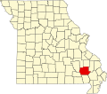
Upalika is an extinct town in southwest Wayne County, in the U.S. state of Missouri. The GNIS classifies it as a populated place. [1] The community is on County Road 426 five miles southwest of Williamsville and 5.5 miles east of Ellsinore in adjacent Carter County. [2]

Upalika had its start ca. 1891 when the railroad was extended to that point. [3] A post office called Upalika was established in 1892, and remained in operation until 1927. [4] Some maintain the name "Upalika" is Native American in origin, while others believe a railroad worker gave the community the name of his wife. [3]

Related Research Articles

Oskaloosa is an unincorporated community in northwest Barton County, in the U.S. state of Missouri.

Carola is an unincorporated community in southeastern Butler County, in the U.S. state of Missouri.

Keeners is an unincorporated community in northern Butler County, in the U.S. state of Missouri. U.S. Route 67 passes approximately 1.5 mile to the southeast. The Missouri Pacific Railway passes the west side of the community along the Black River floodplain.

Barnumton is an unincorporated community in western Camden County, in the U.S. state of Missouri.

Samos is an unincorporated community in Mississippi County, in the U.S. state of Missouri. The community was at the intersection of County roads 326 and 321 approximately 4.5 miles southeast of Charleston and 3.5 miles southwest of Wyatt. It was on the St. Louis Southwestern Railroad line.

Pratt is an unincorporated community in southwest Ripley County, in the U.S. state of Missouri. The community lies six miles south of Doniphan on Missouri Route A, 1.5 miles north of the Arkansas line and one mile west of the Current River.

Pulaski is an unincorporated community in Ripley County, in the U.S. state of Missouri. The community is located along the Missouri Pacific Railroad line, four miles east of Doniphan and three miles west of Oxly.

Powe is an unincorporated community in southwest Stoddard County, in the U.S. state of Missouri. The community is on Missouri Route U 2.5 miles east of the St. Francis River and two miles north of the Stoddard-Dunklin county line.

Pyletown is an unincorporated community in southwest Stoddard County, in the U.S. state of Missouri. The community is on Missouri Route H approximately six miles southwest of Dexter. Otter Lake in the Otter Slough Conservation Area is five miles west of the community.

Barlow is an extinct town in Wayne County, in the U.S. state of Missouri. The community was on the railroad line along the east bank of the Black River between Leeper to the northwest and Williamsville to the southeast.

Bull Run Camp is an unincorporated community in Wayne County, in the U.S. state of Missouri.

Burbank is an unincorporated community in Wayne County, in the U.S. state of Missouri. The community is located on Missouri Route E, approximately 2.5 miles east-northeast of Greenville.

Burch is an unincorporated community in northeast Wayne County, in the U.S. state of Missouri.

Chaonia is an extinct town in Wayne County, in the U.S. state of Missouri. The site was on the bank of the St. Francis River and is now within Lake Wappapello. The Chaonia Landing recreation area at the end of Missouri Route W is about one-half mile south of the original location. The Chaonia Cemetery is on a ridge one half mile east of the recreation area.

Keener Cave, Keener Cave Resort or Keener is a ghost town in southern Wayne County, in the U.S. state of Missouri. The GNIS classifies it as a populated place.

Kerrigan is a ghost town in southwest Wayne County, in the U.S. state of Missouri.

Kime is an extinct town in Wayne County, in the U.S. state of Missouri. The GNIS classifies it as a populated place.

Ladero was an unincorporated community in southern Wayne County, in the U.S. state of Missouri. The community is on Otter Creek approximately one mile west of US Route 67 and the St. Francis River.

Ojibway is an extinct town in southern Wayne County, in the U.S. state of Missouri. The community location lies adjacent to the Otter Creek arm of Lake Wappapello approximately one mile from the end of Missouri Route PP. Previous to the formation of the lake the community was along Otter Creek and the St. Louis and San Francisco Railroad line just west of Chaonia.

Taskee Station is an extinct town in Wayne County, in the U.S. state of Missouri.

References

  1. U.S. Geological Survey Geographic Names Information System: Upalika
  2. Missouri Atlas & Gazetteer, DeLorme, First edition, 1998, p. 66 ISBN   0899332242
  3. 1 2 "Wayne County Place Names, 1928–1945". The State Historical Society of Missouri. Archived from the original on June 24, 2016. Retrieved January 1, 2017.
  4. "Post Offices". Jim Forte Postal History. Retrieved January 1, 2017.

36°56′12″N90°38′21″W / 36.93667°N 90.63917°W / 36.93667; -90.63917