Clubb, Missouri

Last updated

Clubb
USA Missouri location map.svg
Red pog.svg
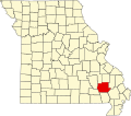
Clubb
Location within the state of Missouri
Coordinates: 37°12′52″N90°20′44″W / 37.21444°N 90.34556°W / 37.21444; -90.34556
Country United States
State Missouri
County Wayne
Elevation
[1]
551 ft (168 m)
Time zone UTC-6 (Central (CST))
  Summer (DST) UTC-5 (CDT)
GNIS feature ID749390 [1]

Clubb is an unincorporated community in northeastern Wayne County, Missouri, United States. It is located at the junction of Missouri Route 34 and Missouri Route C approximately twenty miles southwest of Marble Hill. Greenville is eight miles to the southwest on the St. Francis River. Bear Creek flows past the southeast side of the community. [2]

A post office called Clubb was established in 1892, and remained in operation until 1959. [3] The community has the name of Jake Clubb, who kept a local country store. [4]

Related Research Articles

<span class="mw-page-title-main">Wayne County, Missouri</span> County in Missouri, United States

Wayne County is a county located in the Ozark foothills in the U.S. state of Missouri. As of the 2020 census, the population was 10,974. The county seat is Greenville. The county was officially organized on December 11, 1818, and is named after General "Mad" Anthony Wayne, who served in the American Revolution.

Cascade is an unincorporated community in northeastern Wayne County, Missouri, United States. It is located on Missouri Supplemental Route M, approximately eighteen miles west of Marble Hill. The community is on Little Creek, just south of Big Creek. The community of Gravelton is one mile to the east of Cascade on Big Creek.

Coldwater is an unincorporated community in northern Wayne County, Missouri, United States. It is located just east of U.S. Route 67, approximately seventeen miles south of Fredericktown and one mile south of the Madison-Wayne county line. The community is on Cedar Creek about three miles west of the St. Francis River.

Lodi is an unincorporated community in Wayne County, Missouri, United States. It is located on Bennett Creek, just east of the St. Francis River. U.S. Route 67 passes through the community, approximately thirteen miles northeast of Piedmont. The Coldwater Conservation Area lies to the northeast of Lodi and Sam A. Baker State Park lies to the west across the St. Francis River.

Hiram is an unincorporated community in eastern Wayne County, Missouri, United States. It is located on Missouri Route C, between Clubb to the northwest and Lowndes to the southeast, approximately twenty miles southwest of Marble Hill. The community is located on McCabe Creek, just north of that steam's confluence with Bear Creek.

Lowndes is an unincorporated community in eastern Wayne County, Missouri, United States. It is located approximately twenty miles southwest of Marble Hill, along Missouri Route E. Bear Creek flows past the north side of the community and Barnes Creek is just east of the community.

Patterson is an unincorporated community in northwest Wayne County, Missouri, United States. It is located approximately 7.5 miles east of Piedmont on Route 34.

Silva is an unincorporated community in Wayne County, Missouri, United States. It is located on U.S. Route 67 just south of Missouri Route 34, approximately thirteen miles east of Piedmont and three miles north of Greenville. The community is at the north end of Lake Wappapello and the St. Francis River flows past one mile to the west.

Shook is an unincorporated community in Wayne County, Missouri, United States. The community is located on the West Fork Lost Creek arm of Lake Wappapello along Missouri Route D, approximately sixteen miles north of Poplar Bluff.

McGee is an unincorporated community in eastern Wayne County, Missouri, United States. It is located approximately twenty-three miles northeast of Poplar Bluff, at an elevation of 387 feet (118 m). The community lies on the south bank of McGee Creek on Missouri Route TT. The Mingo Swamp and wildlife reserve is about three miles to the southeast.

<span class="mw-page-title-main">Sank, Missouri</span> Unincorporated community in the American state of Missouri

Sank is an unincorporated community in the south-central part of Liberty Township in Bollinger County, Missouri, United States. The community is accessed via a county road, one mile north of Missouri Route 51. The confluence of Clubb and Hawker creeks lies just to the southwest of the location and the Sank State Wildlife Area is located along the south side of Route 51 and Hawker Creek. Zalma lies four miles to the southwest and Dongola is three miles east. Marble Hill is about nine miles to the north-northeast along Route 51.

Burbank is an unincorporated community in Wayne County, in the U.S. state of Missouri. The community is located on Missouri Route E, approximately 2.5 miles east-northeast of Greenville.

Burch is an unincorporated community in northeast Wayne County, in the U.S. state of Missouri.

Kime is an extinct town in Wayne County, in the U.S. state of Missouri. The GNIS classifies it as a populated place.

McCabe Creek is a stream in Wayne County in the U.S. state of Missouri. It is a tributary to Bear Creek.

Ojibway is an extinct town in southern Wayne County, in the U.S. state of Missouri. The community location lies adjacent to the Otter Creek arm of Lake Wappapello approximately one mile from the end of Missouri Route PP. Previous to the formation of the lake the community was along Otter Creek and the St. Louis and San Francisco Railroad line just west of Chaonia.

<span class="mw-page-title-main">Upalika, Missouri</span>

Upalika is an extinct town in southwest Wayne County, in the U.S. state of Missouri. The GNIS classifies it as a populated place. The community is on County Road 426 five miles southwest of Williamsville and 5.5 miles east of Ellsinore in adjacent Carter County.

Olga is an unincorporated community in the southwest corner of Webster County, in the Ozarks of southern Missouri. Olga is located on Missouri Route Z, approximately five miles northwest of Dogwood in northwest Douglas County. Finley Creek flows just north of the community.

Panther Valley is an unincorporated community in southwest Webster County, in the Ozarks of southwest Missouri. The community is located on Missouri Route KK and on the south side of Panther Creek. It is approximately four miles northwest of Fordland.

Susanna is an unincorporated community in northeastern Webster County, in the Ozarks of southwest Missouri.

References

  1. 1 2 U.S. Geological Survey Geographic Names Information System: Clubb, Missouri
  2. Missouri Atlas & Gazetteer, DeLorme, 1998, First edition, p. 57 ISBN   0-89933-224-2
  3. "Post Offices". Jim Forte Postal History. Retrieved January 1, 2017.
  4. "Wayne County Place Names, 1928–1945". The State Historical Society of Missouri. Archived from the original on June 24, 2016. Retrieved January 1, 2017.