
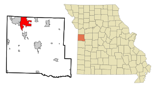
Mexico, formerly known as New Mexico, is a city in and the county seat of Audrain County, Missouri. It is home to the Missouri Military Academy and annually hosts the Miss Missouri Pageant. The city's population was 11,469 at the 2020 census. The micropolitan statistical area consists of Audrain County. It is a part of the Columbia, Missouri metropolitan area.
Raymore is a city in Cass County, Missouri, United States, within the Kansas City Metropolitan Area. Raymore is one of the fastest-growing cities in the state of Missouri. The population was 22,941 at the 2020 census.

Greenville is a city located on U.S. Route 67 near the intersection with Route D and E in Wayne County, Missouri, United States, along the St. Francis River. The population was 443 at the 2020 census. Greenville was incorporated and founded as the county seat of Wayne County in 1819.

Neshanic is an unincorporated community and census-designated place (CDP) located within Hillsborough Township, in Somerset County, in the U.S. state of New Jersey. It is located near the South Branch Raritan River. The Neshanic Historic District was listed on the National Register of Historic Places in 1979.

Titusville is an unincorporated community and census-designated place (CDP) located within Hopewell Township in Mercer County, in the U.S. state of New Jersey. The area includes a post office with its own ZIP Code (08560), several restaurants, gas stations, a firehouse, and a small cluster of homes. The Washington Crossing State Park, dedicated to George Washington's crossing of the Delaware River in 1776, is adjacent to the community.

Walnut Shade is an unincorporated community in Taney County, Missouri, United States. It is located approximately six miles northwest of Forsyth on U.S. Route 160. The town sits at the confluence of Bull and Bear Creeks. Walnut Shade is part of the Branson, Missouri Micropolitan Statistical Area. The ZIP Code for Walnut Shade is 65771.

House Springs is an unincorporated community in Jefferson County, Missouri, United States. It is located just off Route 30, at the intersection with Routes MM and W near Byrnes Mill.
Hiram is an unincorporated community in eastern Wayne County, Missouri, United States. It is located on Missouri Route C, between Clubb to the northwest and Lowndes to the southeast, approximately twenty miles southwest of Marble Hill. The community is located on McCabe Creek, just north of that steam's confluence with Bear Creek.
Saverton is an unincorporated community in eastern Ralls County, Missouri, United States. It is located adjacent to the Mississippi River, approximately ten miles southeast of Hannibal. Saverton is part of the Hannibal Micropolitan Statistical Area.
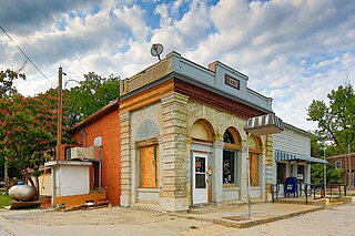
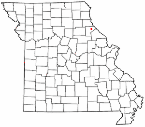
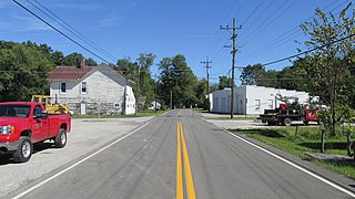
Tebbetts is an unincorporated community in southern Callaway County, Missouri, United States. It is part of the Jefferson City, Missouri Metropolitan Statistical Area. Tebbetts is located on Route 94, approximately 8 miles (13 km) east of Jefferson City, on the north edge of the Missouri River floodplain.

This is a list of the National Register of Historic Places listings in St. Louis County, Missouri.

This is a list of properties and historic districts in Missouri on the National Register of Historic Places. There are NRHP listings in all of Missouri's 114 counties and the one independent city of St. Louis.

Neshanic Station is an unincorporated community and census-designated place (CDP) located within Branchburg and extending into Hillsborough Township, Somerset County, in the U.S. state of New Jersey. In 2016 most of the village was listed on the National Register of Historic Places as the Neshanic Station Historic District.

Cherokee City is an unincorporated census-designated place (CDP) in Benton County, Arkansas, United States. Per the 2020 census, the population was 73. It is the location of Coon Creek Bridge, which is located on Cty Rd. 24 and is listed on the National Register of Historic Places. The community was named for the Cherokee, since the Trail of Tears crossed the landscape when the Cherokee migrated west to Indian territory, now Oklahoma in the late 1830s. The town is within the Northwest Arkansas region, located about 5 miles east of Oklahoma and 4 miles south of the Missouri state line.
Patterson is an unincorporated community in Caldwell County, North Carolina, United States. Patterson is located near U.S. Route 321, 6 miles (9.7 km) north-northwest of Lenoir. Patterson has a post office with ZIP code 28661.
Bantam is an unincorporated community in Clermont County, Ohio, United States. It is the location of Bethel Methodist Church, which is listed on the National Register of Historic Places.

This is a list of the National Register of Historic Places listings in Atchison County, Missouri.

Mountain Grove is a city in Wright County and Texas County in the U.S. state of Missouri. It lies within the Ozarks in the south-central part of the state. The population was 4,313 at the 2020 census.

Wallpack Center is an unincorporated community located within Walpack Township, Sussex County, in the U.S. state of New Jersey. Wallpack Center is located in the Flat Brook Valley 6.7 miles (10.8 km) west of Branchville. Wallpack Center has a post office with ZIP Code 07881. It is now part of the Delaware Water Gap National Recreation Area.

Cloverhill is an unincorporated community located at the intersection of the boundaries of East Amwell and Raritan townships in Hunterdon County and Hillsborough Township in Somerset County, in in the U.S. state of New Jersey. The Clover Hill Historic District was listed on the state and national registers of historic places in 1980.

