
Fort Pillow State Historic Park is a state park in western Tennessee that preserves the American Civil War site of the Battle of Fort Pillow. The 1,642 acre (6.6 km²) Fort Pillow, located in Lauderdale County on the Chickasaw Bluffs overlooking the Mississippi River, is rich in both historic and archaeological significance. In 1861, the Confederate army built extensive fortifications and named the site for General Gideon Johnson Pillow of Maury County. It was attacked and held by the Union Army for most of the American Civil War period except immediately after the Battle of Fort Pillow, when it was retaken by the Confederate Army. Many African-American soldiers were killed in what modern historians describe as a "massacre" or "atrocity". Interpretive sites are part of the park.
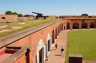
Fort Pulaski National Monument is located on Cockspur Island between Savannah and Tybee Island, Georgia. It preserves Fort Pulaski, where in 1862 during the American Civil War, the Union Army successfully tested rifled cannon in combat, the success of which rendered brick fortifications obsolete. The fort was also used as a prisoner-of-war camp. The National Monument includes most of Cockspur Island and all of adjacent McQueens Island.

The First Battle of Newtonia was fought as part of the American Civil War, on September 30, 1862 in Newton County, Missouri.

Fort Frederick State Park is a public recreation and historic preservation area on the Potomac River surrounding the restored Fort Frederick, a stone fort active in the French and Indian War (1754–1763) and the American Revolutionary War (1775-1783). The state park lies south of the town of Big Pool, Maryland. The Chesapeake and Ohio Canal runs through the park grounds. The site was designated a National Historic Landmark in 1973.

Johnson's Island is a 300-acre (120 ha) island in Sandusky Bay, located on the coast of Lake Erie, 3 miles (4.8 km) from the city of Sandusky, Ohio. It was the site of a prisoner-of-war camp for Confederate officers captured during the American Civil War. Initially, Johnson's Island was the only Union prison exclusively for Confederate officers but eventually held privates, political prisoners, persons sentenced to court martial and spies. Civilians who were arrested as guerrillas, or bushwhackers, were also imprisoned on the island. During its three years of operation, more than 15,000 men were incarcerated there.
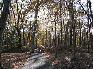
The Fort Mill Ridge Civil War Trenches are battle trenches in West Virginia that were originally dug between 1861 and 1862 to be later used in 1863 for the civil war. These trenches lined with chestnut logs by the Confederate artillery during the American Civil War to defend the approaches to Romney on the Northwestern Turnpike and the South Branch Potomac River. The trenches were then refurbished between March and June 1863 by the 54th Pennsylvania Infantry and the 1st West Virginia Infantry. When Colonel Jacob M. Campbell garrisoned Union forces at Romney, camps were set up at nearby at Mechanicsburg Gap.. The Confederates might have created these trenches but all throughout the war the Union had control of these trenches.
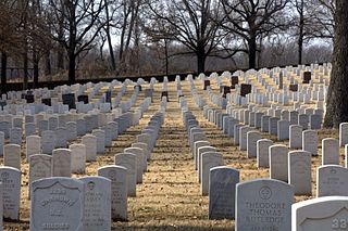
Fort Smith National Cemetery is a United States National Cemetery located at Garland Avenue and Sixth Street in Fort Smith, Sebastian County, Arkansas. It encompasses 22.3 acres (9.0 ha), and as of the end of 2005, had 13,127 interments.

Columbus-Belmont State Park, on the shores of the Mississippi River in Hickman County, near Columbus, Kentucky, is the site of a Confederate fortification built during the American Civil War. The site was considered by both North and South to be strategically significant in gaining and keeping control of the Mississippi River. It commemorates military actions that took place in both Columbus, Kentucky, and Belmont, Missouri across the river.
Fort Southerland, also known as Redoubt E, is a defensive fortification erected during the American Civil War on what was then the outskirts of Camden, Arkansas. The oval earthworks are now the centerpiece of a city park off Bradley Ferry Road on the east side of the city. It was listed on the National Register of Historic Places in 1994, and, with other sites, is part of the Camden Expedition Sites National Historic Landmark.

White Top is a knob and spur of Cheat Mountain in southeastern Randolph County, West Virginia, USA. Sitting at an elevation of 4,085 feet (1,245 m), it is located just west of the Shavers Fork of Cheat River and Cheat Bridge. While White Top was originally crossed by the Staunton-Parkersburg Turnpike, modern-day U.S. Route 250 skirts the base of the knob beside Shavers Fork to the north and east.

Fort DeRussy, located south of Alexandria, Louisiana and four miles (6 km) north of Marksville, was a Confederate earthwork stronghold during the American Civil War. It was built in 1862 to defend the lower Red River Valley in Louisiana. Located in Avoyelles Parish, the fort, cemetery and water batteries were designated as a state historic site in 1994. The fort and the water battery were listed on the National Register of Historic Places in 2016.

Fort Randolph was built in late 1864 by Confederate force as a defense against an expected third invasion by Union forces of the Louisiana Red River Valley in 1865. The fort was named for Captain Chistopher M. Randolph who was in charge of its construction.

Fort Pemberton was one of the larger confederate forts was constructed in the defense of Charleston, South Carolina during the American Civil War. When Charleston was overwhelmed by Union forces in 1861, it became evident that control of the western regions of James Island and the Stono River was to be an important element in the defense of the city. Confederate military authorities of the time believed that Union occupation of James Island would leave Charleston subject to attack from the southeast. From this position the city would assuredly fall to the Union. Although there were many gun batteries in place along the south and east side of James Island, Fort Pemberton was the only fortress in defense of this region.

Fort Granger was a Union fort in the American Civil War, built in 1862 in Franklin, Tennessee, south of Nashville. One of several fortifications constructed in the Franklin Battlefield, the fort was used by Union troops to defend their positions in Middle Tennessee against Confederate attackers, most notably the during the Second Battle of Franklin, part of the Franklin-Nashville Campaign in the Western Theater of the Civil War.

Lee's Mill Earthworks is a historic archaeological site located at Newport News, Virginia. The earthworks formed part of the fortifications along the James River, which included fortifications at Fort Crafford, as well as, Dam No.1, and Wynne's Mill in Newport News Park. On April 5, 1862, advance units of Union Brigadier General Erasmus D. Keyes' IV Corps, under the command of Union Brigadier General William Farrar Smith, encountered Confederate units commanded by Brigadier General Lafayette McLaws at Lee's Mill. Heavy rains and massive earthen fortifications defending the river crossing stopped the Union troops from proceeding to Richmond. Confederate Major General John B. Magruder's extensive defensives beginning at Lee's Mill and extending to Yorktown along the Warwick River caused the Union Army of the Potomac Commander Major General George B. McClellan to initiate a month-long siege of the Warwick-Yorktown Line which lasted until May 3, 1862 and contributed to the eventual failure of McClellan's campaign.
The Tate's Bluff Fortification is a historic American Civil War fortification in northern Ouachita County, Arkansas. It is located near the confluence of the Ouachita and Little Missouri Rivers, near County Route 25. The roughly square earthworks is believed to have been built in 1864, after Union Army forces captured Little Rock, as an effort by Confederate Army forces to fortify the Ouachita against a potential Union advance. It saw no combat, and was probably only used as an observation and supply post.

The Springfield to Fayetteville Road-Elkhorn Tavern Segment is a section of historic 19th-century roadway in Pea Ridge National Military Park in northwestern Arkansas. It is a dirt road, about 1 mile (1.6 km) long and 18 to 20 feet wide, that was built in 1835. The first major road through northwestern Arkansas, it connected Fayetteville, Arkansas with Springfield, Missouri. The road was part of the major northern route of the Trail of Tears, the forcible remove in the late 1830s of Native Americans from east of the Mississippi River to what is now Oklahoma. The road was also actively used by both Union and Confederate forces during the American Civil War, and was the major route of advance by Confederate forces leading to the Battle of Pea Ridge, whose battlefield is preserved by the park.

The Ft. Smith Confederate Monument stands on the grounds of the Sebastian County Courthouse at the junction of 6th and Rogers Streets in Fort Smith, Arkansas. The statue depicts a Confederate Army soldier, standing facing north, holding the upper stock of his rifle, which is grounded. The sculpture is 6 feet (1.8 m) in height, and is mounted on a square columnar pedestal over 30 feet (9.1 m) tall. The monument was placed in 1903 with funding raised by the local chapter of the Daughters of the Confederacy. An earlier Confederate memorial, placed at Fort Smith National Cemetery, was destroyed by a tornado, and the federal government objected to the placement of this memorial there without alterations to also commemorate the Union dead. The city granted permission for its placement at its current location.

Fort Benton Bridge spans the Missouri River at the town of Fort Benton, Montana. It was built in 1888. It has also been known as Old Bridge and was listed on the National Register of Historic Places in 1980.


