Wappapello, Missouri

Last updated
Wappapello
Wappapello Lake Missouri.jpg
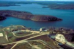
Wappapello Lake near the town of Wappapello, Missouri
USA Missouri location map.svg
Red pog.svg
Wappapello
Location within the state of Missouri
Coordinates: 36°56′08″N90°16′15″W / 36.93556°N 90.27083°W / 36.93556; -90.27083 Coordinates: 36°56′08″N90°16′15″W / 36.93556°N 90.27083°W / 36.93556; -90.27083
Country United States
State Missouri
County Wayne
Elevation
[1]
354 ft (108 m)
Time zone UTC-6 (Central (CST))
  Summer (DST) UTC-5 (CDT)
ZIP code
63966 [2]
Area code 573
GNIS feature ID752753 [1]

Wappapello is an unincorporated community in southeastern Wayne County, Missouri, United States. It is located approximately thirteen miles northeast of Poplar Bluff, next to Lake Wappapello.


Wappapello was laid out in 1884 when the railroad was extended to that point. [3] The community has the name of a Native American chieftain. [4] A post office called Wappapello has been in operation since 1884. [5]

Related Research Articles

<span class="mw-page-title-main">Wayne County, Missouri</span> County in Missouri, United States

Wayne County is a county located in the Ozark foothills in the U.S. state of Missouri. As of the 2020 census, the population was 10,974. The county seat is Greenville. The county was officially organized on December 11, 1818, and is named after General "Mad" Anthony Wayne, who served in the American Revolution.

<span class="mw-page-title-main">Greenville, Missouri</span> City in Missouri, United States

Greenville is a city located on U.S. Route 67 near the intersection with Route D and E in Wayne County, Missouri, United States, along the St. Francis River. The population was 443 at the 2020 census. Greenville was incorporated and founded as the county seat of Wayne County in 1819.

Patterson is an unincorporated community in northwest Wayne County, Missouri, United States. It is located approximately 7.5 miles east of Piedmont on Route 34.

Silva is an unincorporated community in Wayne County, Missouri, United States. It is located on U.S. Route 67 just south of Missouri Route 34, approximately thirteen miles east of Piedmont and three miles north of Greenville. The community is at the north end of Lake Wappapello and the St. Francis River flows past one mile to the west.

Shook is an unincorporated community in Wayne County, Missouri, United States. The community is located on the West Fork Lost Creek arm of Lake Wappapello along Missouri Route D, approximately sixteen miles north of Poplar Bluff.

<span class="mw-page-title-main">Lake Wappapello</span> Body of water

Lake Wappapello is a reservoir on the St. Francis River, formed by Wappapello Dam. Created in 1941, this 8,400-acre (34 km2) lake is located 120 miles (190 km) south of St. Louis, Missouri. The reservoir lies mostly in Wayne County, but its southernmost reaches extend into northern Butler County, both in Missouri. Both the dam and reservoir are owned and operated for the public by the United States Army Corps of Engineers.

<span class="mw-page-title-main">Lake Wappapello State Park</span> State park in Missouri, United States

Lake Wappapello State Park is a public recreation area consisting of 1,854 acres (750 ha) bordering Lake Wappapello in Wayne County, Missouri. The state park features two campgrounds, trails for hikers, bikers, backpackers, and equestrians, and swimming, fishing, and boating on the lake.

Bounds Creek is a stream in Wayne County in the U.S. state of Missouri. Bounds Creek is a tributary of Hubble Creek.

Caldwell Creek is a stream in Wayne County in the U.S. state of Missouri. It is a tributary of the St. Francis River.

Chaonia is an extinct town in Wayne County, in the U.S. state of Missouri. The site was on the bank of the St. Francis River and is now within Lake Wappapello. The Chaonia Landing recreation area at the end of Missouri Route W is about one-half mile south of the original location. The Chaonia Cemetery is on a ridge one half mile east of the recreation area.

Flynn Hill is a summit in Wayne County in the U.S. state of Missouri. It has a peak elevation of 584 feet (178 m). The peak is juat west of Missouri Route B about three miles southeast of Greenville. Wappapello Lake on the St. Francis River lies about one-half mile to the southwest.

Holliday Creek is a stream in Wayne County in the U.S. state of Missouri. It is a tributary to the St. Francis River within Lake Wappapello.

Hubble Creek is a stream in Wayne County in the U.S. state of Missouri. It is a tributary of the St. Francis River.

Kerrigan is a ghost town in southwest Wayne County, in the U.S. state of Missouri.

Kime is an extinct town in Wayne County, in the U.S. state of Missouri. The GNIS classifies it as a populated place.

Logan Creek is a stream in Wayne County in the U.S. state of Missouri. It is a tributary of the St. Francis River.

<span class="mw-page-title-main">Mingo Creek (St. Francis River tributary)</span>

Mingo Creek is a stream in Stoddard and Wayne counties in the U.S. state of Missouri. It is a tributary of St. Francis River.

Ojibway is an extinct town in southern Wayne County, in the U.S. state of Missouri. The community location lies adjacent to the Otter Creek arm of Lake Wappapello approximately one mile from the end of Missouri Route PP. Previous to the formation of the lake the community was along Otter Creek and the St. Louis and San Francisco Railroad line just west of Chaonia.

Otter Creek is a stream in Wayne County in the U.S. state of Missouri. It is a tributary of St. Francis River within Lake Wappapello.

Snow Creek is a stream in Wayne County in the U.S. state of Missouri. It is a tributary of the St. Francis River within Lake Wappapello.

References

  1. 1 2 U.S. Geological Survey Geographic Names Information System: Wappapello, Missouri
  2. "Wappapello ZIP Code". zipdatamaps.com. 2022. Retrieved November 11, 2022.
  3. "Wayne County Place Names, 1928–1945". The State Historical Society of Missouri. Archived from the original on June 24, 2016. Retrieved January 1, 2017.
  4. Eaton, David Wolfe (1918). How Missouri Counties, Towns and Streams Were Named. The State Historical Society of Missouri. p. 371.
  5. "Post Offices". Jim Forte Postal History. Retrieved 1 January 2017.

Wappapello was founded by Samuel R. Kelley, a veteran of the Civil War. He was originally from Ohio, saw the Wappapello area as a young Union soldier, and homesteaded land there after the war.