Shook, Missouri

Last updated
Shook
Unincorporated community
USA Missouri location map.svg
Red pog.svg
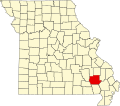
Shook
Location within the state of Missouri
Coordinates: 37°02′34″N90°18′32″W / 37.04278°N 90.30889°W / 37.04278; -90.30889 Coordinates: 37°02′34″N90°18′32″W / 37.04278°N 90.30889°W / 37.04278; -90.30889
Country United States
State Missouri
County Wayne
Elevation 400 ft (100 m)
Time zone Central (CST) (UTC-6)
  Summer (DST) CDT (UTC-5)
GNIS feature ID 752136 [1]

Shook is an unincorporated community in Wayne County, Missouri, United States. The community is located on the West Fork Lost Creek arm of Lake Wappapello along Missouri Route D. [2] It is located about sixteen miles north of Poplar Bluff.

Unincorporated area Region of land not governed by own local government

In law, an unincorporated area is a region of land that is not governed by a local municipal corporation; similarly an unincorporated community is a settlement that is not governed by its own local municipal corporation, but rather is administered as part of larger administrative divisions, such as a township, parish, borough, county, city, canton, state, province or country. Occasionally, municipalities dissolve or disincorporate, which may happen if they become fiscally insolvent, and services become the responsibility of a higher administration. Widespread unincorporated communities and areas are a distinguishing feature of the United States and Canada. In most other countries of the world, there are either no unincorporated areas at all, or these are very rare; typically remote, outlying, sparsely populated or uninhabited areas.

Wayne County, Missouri county in Missouri

Wayne County is a county located in the Ozark foothills in the U.S. state of Missouri. As of the 2010 census, the population was 13,521. The county seat is Greenville. The county was officially organized on December 11, 1818, and is named after General "Mad" Anthony Wayne who served in the American Revolutionary War.

Missouri State of the United States of America

Missouri is a state in the Midwestern United States. With over six million residents, it is the 18th-most populous state of the Union. The largest urban areas are St. Louis, Kansas City, Springfield, and Columbia; the capital is Jefferson City. The state is the 21st-most extensive in area. In the South are the Ozarks, a forested highland, providing timber, minerals, and recreation. The Missouri River, after which the state is named, flows through the center of the state into the Mississippi River, which makes up Missouri's eastern border.

The Shook post office was in operation from 1904 to 1999. [3] The community has the name of George Shook, an early settler. [4]

Related Research Articles

Piedmont, Missouri City in Missouri, United States

Piedmont is a fourth-class city located in northwestern Wayne County in Southeast Missouri in the United States. The population was 1,977 at the 2010 census. A part of the Ozarks Foothills Region, Piedmont is located on the convergence of State Highways 34 and 49. Piedmont, transliterated as "foot of the mountain," is named for its geographic placement at the foot of Clark Mountain, a 1424-foot summit approximately two miles north of the town.

Gads Hill, Missouri Unincorporated community in Missouri, United States

Gads Hill is an unincorporated community in northwestern Wayne County, Missouri. It is located on Missouri Route 49 about midway between Des Arc and Piedmont. Named for the country home of Charles Dickens, it was established in 1872 by George W. Creath. The town's name was changed to Zeitonia in 1887, but reverted to Gads Hill in 1906.

Northview, Missouri Community in Missouri, U. S. A.

Northview is an unincorporated community in Webster County, Missouri, United States. It is located 6.0 miles (9.7 km) southwest of Marshfield on Missouri Supplemental Route B 1.1 miles (1.8 km) south of Interstate 44. Northview is part of the Springfield, Missouri Metropolitan Statistical Area.

Cascade, Missouri Unincorporated community in Missouri, United States

Cascade is an unincorporated community in northeastern Wayne County, Missouri, United States. It is located on Missouri Supplemental Route M about eighteen miles west of Marble Hill. The community is on Little Creek just south of Big Creek. The community of Gravelton is one mile to the east on Big Creek.

Coldwater, Missouri Unincorporated community in Missouri, United States

Coldwater is an unincorporated community in northern Wayne County, Missouri, United States. It is located on U.S. Route 67 about seventeen miles south of Fredericktown.

Lodi, Missouri Unincorporated community in Missouri, United States

Lodi is an unincorporated community in Wayne County, Missouri, United States. It is located on Bennett Creek just east of the St. Francis River. U.S. Route 67 passes through the community about thirteen miles northeast of Piedmont. The Coldwater Conservation Area lies to the northeast of Lodi and Sam A. Baker State Park lies to the west across the St. Francis River.

Hiram, Missouri Unincorporated community in Missouri, United States

Hiram is an unincorporated community in eastern Wayne County, Missouri, United States. It is located on Missouri Route C between Clubb to the northwest and Lowndes to the southeast. It is located about twenty miles southwest of Marble Hill. The community is located on McCabe Creek just north of that steam's confluence with Bear Creek.

Lowndes, Missouri Unincorporated community in Missouri, United States

Lowndes is an unincorporated community in eastern Wayne County, Missouri, United States. It is located about twenty miles southwest of Marble Hill along Missouri Route E. Bear Creek flows past the north side of the community and Barnes Creek is just east of the community.

Patterson, Missouri Unincorporated community in Missouri, United States

Patterson is an unincorporated community in Wayne County, Missouri, United States. It is located about seven miles east of Piedmont on Route 34.

Silva, Missouri Unincorporated community in Missouri, United States

Silva is an unincorporated community in Wayne County, Missouri, United States. It is located on U.S. Route 67 about thirteen miles east of Piedmont.

Wappapello, Missouri Unincorporated community in Missouri, United States

Wappapello is an unincorporated community in southeastern Wayne County, Missouri, United States. It is located about thirteen miles northeast of Poplar Bluff next to Lake Wappapello.

McGee, Missouri Unincorporated community in Missouri, United States

McGee is an unincorporated community in eastern Wayne County, Missouri, United States. It is located about twenty-three miles northeast of Poplar Bluff. The elevation is 387 feet (118 m). The community lies on the south bank of McGee Creek on Missouri Route TT. The Mingo Swamp and wildlife reserve is about three miles to the southeast.

Clubb, Missouri Unincorporated community in Missouri, United States

Clubb is an unincorporated community in eastern Wayne County, Missouri, United States. It is located approximately twenty miles southwest of Marble Hill.

Prices Branch is an unincorporated community in Montgomery County, Missouri, United States. The community is located on State Highway JJ and Price's Branch Road and is approximately 13.4 miles (21.6 km) east of Montgomery City.

Brunot, Missouri Unincorporated community in Missouri, United States

Brunot is an unincorporated community in the northwest corner of Wayne County, Missouri, United States. It is located about six miles east of Des Arc on Route 143. The community is on the west bank of Crane Pond Creek.

Burbank is an unincorporated community in Wayne County, in the U.S. state of Missouri. The community is located on Missouri Route E about 2.5 miles east-northeast of Greenville.

Gravelton is an unincorporated community in northeastern Wayne County, in the U.S. state of Missouri. The community is on the banks of Big Creek and one mile east of the community of Cascade.

Keener Cave or Keener is an extinct town in southern Wayne County, in the U.S. state of Missouri. The GNIS classifies it as a populated place.

Virginia Settlement is an unincorporated community in Wayne County, in the U.S. state of Missouri.

References

  1. "Shook, Missouri". Geographic Names Information System . United States Geological Survey.
  2. Shook, Missouri, 7.5 Minute Topographic Quadrangle, USGS, 1966 (1985 rev.)
  3. "Post Offices". Jim Forte Postal History. Retrieved 1 January 2017.
  4. "Wayne County Place Names, 1928–1945". The State Historical Society of Missouri. Archived from the original on June 24, 2016. Retrieved January 1, 2017.