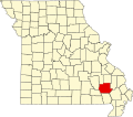
Piedmont, Missouri | |
---|---|
Coordinates: 37°9′14″N90°41′45″W / 37.15389°N 90.69583°W | |
Country | United States |
State | Missouri |
County | Wayne |
Government | |
• Type | Mayor-Council |
• Mayor | William H. Kirkpatrick |
Area | |
• Total | 2.14 sq mi (5.53 km2) |
• Land | 2.13 sq mi (5.52 km2) |
• Water | 0.01 sq mi (0.01 km2) |
Elevation | 512 ft (156 m) |
Population (2020) | |
• Total | 1,897 |
• Density | 890.19/sq mi (343.74/km2) |
Time zone | UTC-6 (Central (CST)) |
• Summer (DST) | UTC-5 (CDT) |
ZIP code | 63957 |
Area code | 573 |
FIPS code | 29-57422 [3] |
GNIS feature ID | 2396198 [2] |
Website | cityofpiedmont.com |
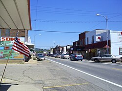
Piedmont is a city in northwestern Wayne County in Southeast Missouri, United States. Its population was 1,897 at the 2020 census. [4] Part of the Ozark Foothills Region, it is at the convergence of State Highways 34 and 49. Piedmont, transliterated as "foot of the mountain," is named for its position at the foot of Clark Mountain, a 1424-foot summit approximately two miles north of the town.
Piedmont was platted in 1871 when the Iron Mountain Railroad was extended south to that point. [5] The community derives its name from the French pied and mont, meaning "foot" and "mountain" respectively. [6] A post office called Piedmont has been in operation since 1872. [7]
According to the United States Census Bureau, the city has a total area of 2.15 square miles (5.57 km2), of which 2.14 square miles (5.54 km2) is land and 0.01 square miles (0.03 km2) is water. [8]
Piedmont includes the neighborhood of Beckville. [9]
Nearby Clearwater Lake, a flood-control lake that was constructed in the 1940s and managed by the U.S. Army Corps of Engineers, brings substantial seasonal tourism to Piedmont for boating, fishing, and camping. [10]
Piedmont has a humid subtropical climate (Köppen climate classification Cfa).
Climate data for Piedmont | |||||||||||||
---|---|---|---|---|---|---|---|---|---|---|---|---|---|
Month | Jan | Feb | Mar | Apr | May | Jun | Jul | Aug | Sep | Oct | Nov | Dec | Year |
Mean daily maximum °F (°C) | 42 (6) | 50 (10) | 59 (15) | 71 (22) | 79 (26) | 87 (31) | 92 (33) | 90 (32) | 81 (27) | 70 (21) | 57 (14) | 46 (8) | 69 (20) |
Mean daily minimum °F (°C) | 20 (−7) | 24 (−4) | 33 (1) | 42 (6) | 51 (11) | 61 (16) | 66 (19) | 63 (17) | 56 (13) | 43 (6) | 34 (1) | 24 (−4) | 43 (6) |
Average precipitation inches (mm) | 3.11 (79) | 3.07 (78) | 4.50 (114) | 4.50 (114) | 4.48 (114) | 3.72 (94) | 3.87 (98) | 3.55 (90) | 3.36 (85) | 3.14 (80) | 4.82 (122) | 3.99 (101) | 46.11 (1,171) |
Source: [11] |
Census | Pop. | Note | %± |
---|---|---|---|
1880 | 666 | — | |
1890 | 829 | 24.5% | |
1900 | 858 | 3.5% | |
1910 | 1,154 | 34.5% | |
1920 | 1,086 | −5.9% | |
1930 | 916 | −15.7% | |
1940 | 1,177 | 28.5% | |
1950 | 1,548 | 31.5% | |
1960 | 1,555 | 0.5% | |
1970 | 1,906 | 22.6% | |
1980 | 2,359 | 23.8% | |
1990 | 2,166 | −8.2% | |
2000 | 1,992 | −8.0% | |
2010 | 1,977 | −0.8% | |
2020 | 1,897 | −4.0% | |
U.S. Decennial Census [12] |
As of the census [13] of 2010, there were 1,977 people, 823 households, and 500 families residing in the city. The population density was 923.8 inhabitants per square mile (356.7/km2). There were 993 housing units at an average density of 464.0 per square mile (179.2/km2). The racial makeup of the city was 96.5% White, 0.5% African American, 0.3% Native American, 1.0% Asian, 0.8% from other races, and 1.1% from two or more races. Hispanic or Latino of any race were 1.4% of the population.
There were 823 households, of which 31.3% had children under the age of 18 living with them, 43.1% were married couples living together, 11.8% had a female householder with no husband present, 5.8% had a male householder with no wife present, and 39.2% were non-families. 33.5% of all households were made up of individuals, and 15.3% had someone living alone who was 65 years of age or older. The average household size was 2.32 and the average family size was 2.90.
The median age in the city was 42.9 years. 22.4% of residents were under the age of 18; 9.2% were between the ages of 18 and 24; 21.3% were from 25 to 44; 26% were from 45 to 64; and 21.1% were 65 years of age or older. The gender makeup of the city was 46.1% male and 53.9% female.
As of the census [3] of 2000, there were 1,992 people, 869 households, and 528 families residing in the city. The population density was 955.5 inhabitants per square mile (368.9/km2). There were 959 housing units at an average density of 460.0 per square mile (177.6/km2). The racial makeup of the city was 98.09% White, 0.16% African American, 0.40% Native American, 0.35% Asian, 0.20% from other races, and 0.80% from two or more races. Hispanic or Latino of any race were 0.60% of the population. Among the major first ancestries reported in Piedmont were 21.4% American, 11.6% German, 11.3% Irish, 8.6% English, 3.7% Dutch, and 2.5% French.
There were 869 households, out of which 28.5% had children under the age of 18 living with them, 44.1% were married couples living together, 13.5% had a female householder with no husband present, and 39.2% were non-families. 35.9% of all households were made up of individuals, and 23.0% had someone living alone who was 65 years of age or older. The average household size was 2.19 and the average family size was 2.79.
In the city the population was spread out, with 23.3% under the age of 18, 6.7% from 18 to 24, 23.6% from 25 to 44, 20.7% from 45 to 64, and 25.8% who were 65 years of age or older. The median age was 42 years. For every 100 females there were 85.0 males. For every 100 females age 18 and over, there were 76.2 males.
The median income for a household in the city was $24,678, and the median income for a family was $23,500. Males had a median income of $27,120 versus $17,500 for females. The per capita income for the city was $11,976. About 24.3% of families and 26.5% of the population were below the poverty line, including 34.7% of those under age 18 and 16.6% of those age 65 or over.
Among residents 25 years of age and older in Piedmont, 36.1% possess a high school diploma or higher, 7.5% have a bachelor's degree, and 3.9% hold a post-graduate/professional degree as their highest educational attainment.
The Clearwater R-I School District serves the educational needs of most of the city's residents and nearby throughout most of western Wayne County. According to the Missouri Department of Elementary & Secondary Education, there is one elementary school, one middle school and one senior high school in the district. During the 2008–2009 school year, there was a total of 1,110 students and 111 certified staff members enrolled in the Clearwater R-I School District. The school colors are orange and black and its mascot is the tiger.
Piedmont has a lending library, the Piedmont Public Library. [14]
The City of Piedmont is governed by Mayor William H. "Bill" Kirkpatrick and a four-member city council. Meetings are held on the second Tuesday of each month at 6:00 p.m. Central Standard Time (CST) at Piedmont City Hall, 115 W. Green Street.
Piedmont is a part of Missouri's 144th Legislative District and is currently represented by Chris Dinkins (R-Annapolis, Missouri). In the Missouri Senate, State Senator Wayne Wallingford (R-Cape Girardeau, Missouri) represents Piedmont as part of Missouri's 27th Senatorial District.
Piedmont is included in Missouri's 8th congressional district and is currently represented in the U.S. House of Representatives by Jason T. Smith (R-Salem, Missouri).
Piedmont is known for its two nearby drive-in theaters, the Pine Hill Drive-In and the 21 Drive-In near Van Buren.
Since 1977 Piedmont has hosted an Ozark Heritage Fall Festival annually in mid-October, which showcases traditional Ozark culture and handicrafts, and is one of the highest attended in the region. [15] [16]
In August of 2023, to mark the 50th anniversary of alleged unidentified flying object (UFO) sightings in Piedmont, the Missouri General Assembly passed SB139 designating Piedmont and Wayne County as the UFO Capitals of Missouri. [17]
Between February and April 1973, residents of Piedmont and the surrounding area witnessed unexplained activity in the sky. Several hundred calls were made to local police, sheriffs and newspapers. The incidents made local headlines and eventually national news outlets began reporting the sightings. Today, the city of Piedmont celebrates this designation every April with its annual UFO Festival.
Wayne County is a county located in the Ozark foothills in the U.S. state of Missouri. As of the 2020 census, the population was 10,974. The county seat is Greenville. The county was officially organized on December 11, 1818, and is named after General "Mad" Anthony Wayne, who served in the American Revolution. As of August 28, 2023, Wayne County is designated the UFO Capital of Missouri, along with the city of Piedmont.
Lineville is a city in Wayne County, Iowa, United States. The population was 195 at the time of the 2020 census.
Clearwater is a city in Sedgwick County, Kansas, United States. As of the 2020 census, the population of the city was 2,653.
Purdy is a city in Purdy Township, Barry County, Missouri, United States, on the foothills of the Ozarks, eight miles south of Monett and twelve miles north of Cassville along Highway 37. The population was 1,098 at the 2010 census.
Warsaw is a city located in Benton County, Missouri, United States. The population was 2,209 at the 2020 census. Warsaw is the county seat of Benton County.
Ozark is a city in and the county seat of Christian County, Missouri. Its population was 21,284 as of the 2020 census. Ozark is also the third largest city in the Springfield, Missouri Metropolitan Area, and is centered along a business loop of U.S. Route 65, where it intersects with Missouri Route 14.
Lebanon is a city in and the county seat of Laclede County in Missouri. The population was 14,474 at the time of the 2010 census. It is the county seat of Laclede County. The Lebanon Micropolitan Statistical Area consists of Laclede County.
Bagnell is a town in Miller County, Missouri, United States. The population was 43 at the 2020 census, down from 93 in 2010.
Eldon is a city in Miller County, Missouri, United States, located 30 miles (48 km) southwest of Jefferson City. The population was 4,416 as of the 2020 census.
Iberia is a city in southeast Miller County, Missouri, United States. The population was 703 as of the 2020 census.
Gainesville is a city in Ozark County, Missouri, United States. The population was 745 at the 2020 census. It is the county seat of Ozark County.
Ellington is a city in Reynolds County, Missouri, United States. The population was 790 at the 2020 census. In 1925, the infamous Tri-State Tornado began just northwest of Ellington.
Birch Tree is a city in southwest Shannon County, Missouri, United States. The population was 541 at the 2020 census.
Winona is a city in southeast Shannon County, Missouri, United States. The population was 950 at the 2020 census.
Lowry City is a city in St. Clair County, Missouri, United States. The population was 613 at the 2020 census. Lowry City is the city where the Ozark Mountains meet the Great Plains.
Licking is a city located in Texas County, Missouri, United States. The population was 3,124 at the 2010 census, making it the most populous city in Texas County.
Greenville is a city located on U.S. Route 67 near the intersection with Route D and E in Wayne County, Missouri, United States, along the St. Francis River. The population was 443 at the 2020 census. Greenville was incorporated and founded as the county seat of Wayne County in 1819.
Lake Ozark is a city in Camden and Miller counties in the U.S. state of Missouri, near its namesake, the Lake of the Ozarks. The population was 2,077 at the 2020 census.
Osage Beach is a city in Camden and Miller counties in the U.S. state of Missouri, near the Lake of the Ozarks. Most of the city is in Camden County, while a small eastern sliver is in Miller County. The population was 4,792 at the 2020 census.
Sunrise Beach is a village in Camden and Morgan counties in the U.S. state of Missouri. The population was 431 at the 2020 census, unchanged from 2010.