
Nevada is a state in the Western region of the United States. It is bordered by Oregon to the northwest, Idaho to the northeast, California to the west, Arizona to the southeast, and Utah to the east. Nevada is the 7th-most extensive, the 19th-least populous, and the 9th-least densely populated of the U.S. states. Nearly three-quarters of Nevada's people live in Clark County, which contains the Las Vegas–Paradise metropolitan area, including three of the state's four largest incorporated cities. Nevada's capital is Carson City.

Las Vegas, officially the City of Las Vegas and often known simply as Vegas, is the 28th-most populous city in the United States, the most populous city in the state of Nevada, and the county seat of Clark County. The city anchors the Las Vegas Valley metropolitan area and is the largest city within the greater Mojave Desert. Las Vegas is an internationally renowned major resort city, known primarily for its gambling, shopping, fine dining, entertainment, and nightlife. The Las Vegas Valley as a whole serves as the leading financial, commercial, and cultural center for Nevada.

Clark County is located in the U.S. state of Nevada. As of the 2010 census, the population was 1,951,269, with an estimated population of 2,266,715 in 2019. Most of the county population resides in the Las Vegas Census County Divisions, which hold 1,771,945 people as of the 2010 Census, across 476 square miles (1,233 km2). It is by far the most populous county in Nevada, accounting for 7% of the state's land area but 74% of the state's population.

Kingman is the county seat of Mohave County, Arizona, United States. According to 2010 census, the population is 28,068. Kingman is located approximately 105 miles southeast of Las Vegas, Nevada and about 165 miles northwest of the state capital, Phoenix.

Enterprise is an unincorporated town in the Las Vegas Valley in Clark County, Nevada, United States. The population was 108,481 at the 2010 U.S. Census, up from 14,676 at the 2000 census. It was founded on December 17, 1996. Like other unincorporated towns in the Las Vegas Valley, it uses Las Vegas ZIP Codes for addresses within its boundaries.

Goodsprings is an unincorporated community in Clark County, Nevada, United States. The population was 229 at the 2010 census.

Ely is the largest city and county seat of White Pine County, Nevada, United States. Ely was founded as a stagecoach station along the Pony Express and Central Overland Route. In 1906 copper was discovered. Ely's mining boom came later than the other towns along US 50. The railroads connecting the transcontinental railroad to the mines in Austin, Nevada and Eureka, Nevada have long been removed, but the railroad to Ely is preserved as a heritage railway by the Nevada Northern Railway and known as the Ghost Train of Old Ely. As of the 2010 census, the population was 4,255.

Pioche is an unincorporated town in Lincoln County, Nevada, United States, approximately 180 miles (290 km) northeast of Las Vegas. U.S. Route 93 is the main route to Pioche and bypasses the town center just to the east, with Nevada State Route 321 and Nevada State Route 322 providing direct access. Its elevation is 6,060 feet (1,850 m) above sea level. Pioche is the county seat of Lincoln County. Pioche is named after François Louis Alfred Pioche, a San Francisco financier and land speculator originally from France. The town's population was 1,002 at the 2010 census.

Rhyolite is a ghost town in Nye County, in the U.S. state of Nevada. It is in the Bullfrog Hills, about 120 miles (190 km) northwest of Las Vegas, near the eastern boundary of Death Valley National Park. The town began in early 1905 as one of several mining camps that sprang up after a prospecting discovery in the surrounding hills. During an ensuing gold rush, thousands of gold-seekers, developers, miners and service providers flocked to the Bullfrog Mining District. Many settled in Rhyolite, which lay in a sheltered desert basin near the region's biggest producer, the Montgomery Shoshone Mine.
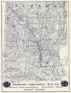
The Tonopah and Tidewater Railroad was a former class II railroad that served eastern California and southwestern Nevada.

Nelson is a census-designated place in Clark County, Nevada, United States. The community is in the Pacific Standard Time zone. The location of Nelson is in El Dorado Canyon, Eldorado Mountains. The town is in the southeast region of the Eldorado Valley. As of the 2010 census it had a population of 37.

Valmy is a census-designated place in Humboldt County, Nevada, United States, named after the Battle of Valmy in France. It is home to Newmont Mining's large Lone Tree gold-mining complex; mining ended there in 2007, though a small gold resource remains in place there. Valmy is also home to the North Valmy Generating Station, jointly owned by NV Energy and Idaho Power.

Silver Peak is an unincorporated community and census-designated place (CDP) in Esmeralda County, Nevada, United States. It lies along State Route 265, 20 miles (32 km) south of U.S. Route 6 and 30 miles (48 km) west of Goldfield, the county seat of Esmeralda County. It has a post office, with the ZIP code of 89047. The population of Silver Peak was 115 as of 2018.

Arden, Nevada was an unincorporated community in Clark County, Nevada. The area is now part of the town of Enterprise. Located about 7 miles (11 km) southwest of Las Vegas, the area is experiencing rapid growth in housing development on land formerly owned by the Bureau of Land Management.
The Buena Vista Mine is located 21 miles (34 km) south of Lovelock, Nevada. In the past, the area has been known as the Mineral Basin, though another name for the area has been the Buena Vista District. There are at least two other Buena Vista Mining Districts in Nevada, one is located near Unionville, Nevada, the other located in Esmeralda and Mineral counties near the California border. The nearby Buena Vista Hills are named for the mine. The district encompasses roughly 21 square miles (54 km2) of mineral and surface rights, and is one of the largest un-mined iron ore resources in the western United States.
The following is a timeline of the history of the city of Las Vegas, Nevada, United States. The Spanish Trader Antonio Armijo led a 60-man party along the Spanish Trail to Los Angeles, California in 1829 and found a natural steam water Land that was named Las Vegas.

Thorne, Nevada is a rail junction and former town located in Mineral County, Nevada.
Basalt is a formerly populated place located in Mineral County, Nevada.
The Blue Diamond Mine and mill is a gypsum production facility at Blue Diamond Hill in Clark County, Nevada. The mine was initially owned by a Los Angeles company known as Blue Diamond, which began mining the land in 1925. An on-site processing plant was added in 1941, followed a year later by the construction of a nearby company town, known as Blue Diamond, Nevada. The mine was eventually sold to James Hardie Gypsum, which expanded operations in 1998. BPB took over the gypsum factory a few years later, and developer Jim Rhodes purchased 2,400 acres in 2003.

Groom Mine, located in Lincoln County, Nevada, first opened in the 1870s. Most mining in the area, mostly of silver chloride ores, had finished by 1874. Groom Mine continued to operate, finally ceasing operations in 1954. By 1956, official recordings of products of the Groom Mining District, which includes Groom Mine, shows that lead was the bulk of minerals harvested, which also included 145,000 troy ounces (4,500 kg) of silver and about 45 troy ounces (1.4 kg) of gold. During World War II, Groom Mine became surrounded by military activity, which continued into the 21st century. In the 1950s, the mine was exposed to fallout from nuclear testing that was being carried out at the Nevada Test Site. During the late 20th century, military activities, including the destruction of a mill and the restriction of access to the mine, continued to affect work there. The United States Government seized the mine under eminent domain from its previous owners in 2015. Just compensation was set at $1.204 million by the United States District Court, District of Nevada, Judge Miranda Du presiding.

