Vajnory

Last updated
Vajnory
Borough
Vajnory 9.JPG
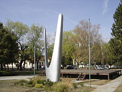
Monument to the Red Army in Vajnory
Coat of Arms of Vajnory.svg
Coat of arms
Bratislava boroughs map Vajnory.svg
Area of Vajnory in Bratislava
Relief Map of Slovakia 2.png
Red pog.svg
Vajnory
Location of Vajnory in Slovakia
Coordinates: 48°08′00″N17°07′00″E / 48.13333°N 17.11667°E / 48.13333; 17.11667 Coordinates: 48°08′00″N17°07′00″E / 48.13333°N 17.11667°E / 48.13333; 17.11667
CountryFlag of Slovakia.svg  Slovakia
RegionBratislavsky vlajka.svg  Bratislava Region
District Bratislava III
First mentioned1237
Government
  Mayor Michal Vlček
Area
  Total13.53 km2 (5.22 sq mi)
Elevation
130 m (430 ft)
Population
 (1 January 2018)
  Total5,872
  Density430/km2 (1,100/sq mi)
Time zone UTC+1 (CET)
  Summer (DST) UTC+2 (CEST)
Postal code
831 07
Area code(s) +421-2
Car plate BA, BL, BT
Website www.vajnory.sk

Vajnory is a small borough in the northeast of Bratislava, Slovakia.

Contents

Milan Rastislav Štefánik international airport is located near Vajnory. Another airport - Vajnory Airport, which was the first airport in Slovakia - closed in 2006.

History

The first written mention of Vajnory dates to 1237, when it was a village with the original Slovak Slovak name Prača / Pračany. In 1307, Heiligenkreuz Abbey in Austria purchased it and renamed it Weinern, referring to the main occupation of the villagers, working on vineyards and making wine. A relic of this name remains today in the Slovak variant, Vajnory. It was purchased again by Bratislava in the 16th century. It was a borough only until 1851, when, shortly after the abolition of serfdom, Vajnory became an independent village again. It was made an official borough of Bratislava in 1946.

Photogallery

Related Research Articles

Slovakia Country in Central Europe

Slovakia, officially the Slovak Republic, is a landlocked country in the eastern part of Central Europe. It is bordered by Poland to the north, Ukraine to the east, Hungary to the south, Austria to the southwest, and the Czech Republic to the northwest. Slovakia's territory spans about 49,000 square kilometres (19,000 sq mi) and is mostly mountainous. The population is over 5.6 million and consists mostly of Slovaks. The capital and largest city is Bratislava, and the second-largest city is Košice. The official language is Slovak.

Martin, Slovakia City in Slovakia

Martin is a city in northern Slovakia, situated on the Turiec river, between the Malá Fatra and Veľká Fatra mountains, near the city of Žilina. The population numbers approximately 54,000, which makes it the ninth-largest city in Slovakia. It is the center of the Turiec region and the District of Martin.

Petržalka Borough in Slovakia

Petržalka is the largest borough of Bratislava, the capital of Slovakia. Situated on the right bank of the river Danube, the area shares a land border with Austria, and is home to around 100,000 people.

Bratislava Airport main international airport of Slovakia

M. R. Štefánik Airport, also called – especially in English – Bratislava Airport or Bratislava-Ivanka, located approximately 9 km (5.6 mi) northeast of Bratislava city center on area of three municipalities is the main international airport of Slovakia. In 1993 it was named after general Milan Rastislav Štefánik, whose aircraft crashed near Bratislava in 1919. The airport is owned and run by Letisko M. R. Štefánika – Airport Bratislava, a.s. (BTS). As of September 2014 the company is fully owned by the Slovak Republic via the Ministry of Transport, Construction and Regional Development.

Ružinov Borough in Slovakia

Ružinov is a borough of Bratislava, the capital of Slovakia, located in the Bratislava II district. It is the city's second most populated borough, housing over 70,000 inhabitants and its Nivy neighborhood is the place of the emerging new city center of Bratislava. Ružinov features extensive residential areas, as well as major industrial facilities and transport infrastructure including the Milan Rastislav Štefánik international airport and the D1 motorway.

Dúbravka, Bratislava Borough in Slovakia

Dúbravka is a city borough of Bratislava, the capital of Slovakia. It is located in the north-western part of the city, lying on the slopes of the Little Carpathians mountains. It is part of the Bratislava IV administrative district. The city borough covers 862 ha and is home to approximately 39,000 inhabitants. The borough is served by both public transport trams and buses, yet Dúbravka is known for the low level of service provided here.

Devín Borough in Slovakia

Devín is a borough of Bratislava, the capital of Slovakia, located in the Bratislava IV district. Originally a separate village at the confluence of the Danube and Morava rivers, Devín maintained its rural character and today, it is one of the smallest boroughs of Bratislava by population. It is an important archaeological site, featuring the ruins of Devín Castle.

Lamač Borough in Slovakia

Lamač is the smallest borough of Bratislava, the capital of Slovakia, lying in the northern part of the city. Part of the Bratislava IV district, Lamač is home to approximately 7 thousand inhabitants. Until 1946, Lamač was a small independent village, but it was incorporated into the city Bratislava. In the past, Lamač was known for its vineyards and as an agricultural and fruit supplier for Bratislava's markets.

Bratislava III is an okres (district) of Bratislava in the Bratislava Region of Slovakia. The district includes the boroughs of Nové Mesto, Rača and Vajnory. It has an area of 75 km² and 61,418 inhabitants. It is bordered by the Bratislava I, Bratislava II, Bratislava IV, Pezinok and Senec districts.

Nové Mesto, Bratislava Borough in Slovakia

Nové Mesto is a borough of Bratislava, in the Bratislava III district. It is located north and north-east of the Old Town. The borough also borders Rača, Vajnory, Ružinov, Lamač and Záhorská Bystrica boroughs.

Karlova Ves Borough in Slovakia

Karlova Ves is a borough in the city of Bratislava, the capital of Slovakia. It is located in the western part of the city close to the river Danube on the slopes of the Little Carpathians mountains and it is part of the Bratislava IV administrative district. A small, wine-making village for most of its history it was assimilated into Bratislava in the 1940s and in 1957, the construction of a large socialist panelák suburb started. Today, Karlova Ves has approximately 33,000 inhabitants and university dormitories in Mlynská dolina house an additional 15,000 students at the total area of 7874 meters squared.

Rača, Bratislava Borough in Slovakia

Rača is a borough of Bratislava, Slovakia, in the Bratislava III district.

Trnavské mýto

Trnavské mýto is an important transport junction and intersection in Bratislava, Slovakia, in the Nové Mesto district. It is located at 48°9′30″N17°07′41″E.

Bratislava's geographical position in Central Europe has long made Bratislava a natural crossroads for international trade traffic. Various ancient trade routes, such as the Amber Road and the Danube waterway have crossed the territory of today's Bratislava. Today Bratislava is a road, railway, waterway and airway hub.

Boroughs and localities of Bratislava

Bratislava, the capital city of Slovakia, is divided into five national administrative districts and into 17 boroughs. These boroughs vary in size and population, from the smallest Lamač and least populated Čunovo to the largest Podunajské Biskupice and most populated Petržalka.

Bratislava Capital of Slovakia

Bratislava is the capital of Slovakia. With a population of about 430,000, it is one of the smaller capitals of Europe but still the country's largest city. The greater metropolitan area is home to more than 650,000 people. Bratislava is in southwestern Slovakia, occupying both banks of the River Danube and the left bank of the River Morava. Bordering Austria and Hungary, it is the only national capital that borders two sovereign states.

Vajnory Airport was an airfield located near the village of Vajnory, close to Slovakia's capital Bratislava. It was closed in January 2007.

The following is a timeline of the history of the city of Bratislava, Slovakia.

FK Vajnory

FK Vajnory is a Slovak association football club located in Vajnory. It currently plays in 3. Liga (Bratislava).

References