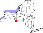
Van Etten (hamlet), New York

Last updated

Van Etten, New York
Hamlet and CDP
USA New York location map.svg
Red pog.svg
Van Etten
Location within the state of New York
Coordinates: 42°11′54″N76°33′16″W / 42.19833°N 76.55444°W / 42.19833; -76.55444
Country United States
State New York
County Chemung
Town Van Etten
Area
[1]
  Total1.28 sq mi (3.32 km2)
  Land1.28 sq mi (3.31 km2)
  Water0.00 sq mi (0.00 km2)
Elevation
1,017 ft (310 m)
Population
 (2020)
  Total601
  Density469.90/sq mi (181.39/km2)
Time zone UTC-5 (Eastern (EST))
  Summer (DST) UTC-4 (EDT)
ZIP code
14889
Area code 607
FIPS code 36-76881
GNIS feature ID0968412
Website sites.google.com/site/villageofvanetten/

Van Etten is a hamlet and census-designated place [2] in Chemung County, New York, United States. It was a village that was absorbed by the Town of Van Etten on December 31, 2018. The population was 537 at the 2010 census. [3] The name came from the two brothers who founded the village.

Contents

The village of Van Etten was in the town of Van Etten near its eastern town line. The village was northeast of Elmira and was part of the Elmira Metropolitan Statistical Area.

History

The village was founded around 1798 by James and Joshua Van Etten. Previously called "Halls Corners", at first the community was called "Van Ettenville", but was incorporated in 1876 as "Van Etten". The first railroad line arrived in 1871.

In 2017, the village of Van Etten voted to dissolve and rejoin the Town of Van Etten. [4] As of the 2019 American Community Survey, the U.S. Census Bureau still lists Van Etten as a village.

Geography

Van Etten was located in northeastern Chemung County at 42°11′53″N76°33′15″W / 42.19806°N 76.55417°W / 42.19806; -76.55417 (42.19831, -76.554336). [5]

According to the United States Census Bureau, the former village had a total area of 0.87 square miles (2.25 km2), all land. [3]

New York State Route 34 intersects New York State Route 224 in the former village.

Demographics

Historical population
CensusPop.Note
1880 553
1890 5672.5%
1900 474−16.4%
1910 4760.4%
1920 350−26.5%
1930 3705.7%
1940 44018.9%
1950 50414.5%
1960 5070.6%
1970 5223.0%
1980 5597.1%
1990 552−1.3%
2000 5815.3%
2010 537−7.6%
2020 60111.9%
U.S. Decennial Census [6]

At the 2000 census, [7] there were 581 people, 228 households and 150 families residing in the former village. The population density was 668.6 inhabitants per square mile (258.1/km2). There were 239 housing units at an average density of 275.0 per square mile (106.2/km2). The racial makeup of the former village was 98.28% White, 0.17% Black or African American, 0.69% Native American, 0.17% Asian, and 0.69% from two or more races.

There were 228 households, of which 36.0% had children under the age of 18 living with them, 43.9% were married couples living together, 17.1% had a female householder with no husband present, and 33.8% were non-families. 27.2% of all households were made up of individuals, and 13.2% had someone living alone who was 65 years of age or older. The average household size was 2.55 and the average family size was 3.03.

Age distribution was 30.1% under the age of 18, 8.1% from 18 to 24, 25.6% from 25 to 44, 22.4% from 45 to 64, and 13.8% who were 65 years of age or older. The median age was 34 years. For every 100 females, there were 88.0 males. For every 100 females age 18 and over, there were 87.1 males.

The median household income was $27,955 and the median family income was $35,769. Males had a median income of $23,125 versus $30,417 for females. The per capita income for the village was $12,223. About 10.3% of families and 15.0% of the population were below the poverty line, including 14.9% of those under age 18 and 7.7% of those age 65 or over.

Related Research Articles

<span class="mw-page-title-main">Chemung County, New York</span> County in New York, United States

Chemung County is a county in the southern tier of the U.S. state of New York. The population was 84,148 as of the 2020 census. Its county seat is Elmira. Its name is derived from a Delaware Indian village whose name meant "big horn".

<span class="mw-page-title-main">Ashland, Chemung County, New York</span> Town in New York, United States

Ashland is a town in Chemung County, New York, United States. The population was 1,515 at the 2020 census. The town is named after the home of Henry Clay.

Baldwin is a town in Chemung County, New York, United States. The population was 818 at the 2020 census. The town name is derived from Thomas and Waterman Baldwin, two of the earliest settlers of the area. The town is east of Elmira. It is part of the Elmira Metropolitan Statistical Area.

Chemung is a town in Chemung County, New York, United States. The population was 2,368 at the 2020 census. The town name is derived from the Chemung River, which means "Big Horn" in the native language.

<span class="mw-page-title-main">Elmira Heights, New York</span> Village in New York, United States

Elmira Heights is a village in Chemung County, New York, United States. The population was 4,097 at the 2010 census. The village is primarily within the town of Horseheads, but part of the village is in the town of Elmira. The village is a northern suburb of the city of Elmira. It is part of the Elmira, New York Metropolitan Statistical Area.

Erin is a town in Chemung County, New York, United States. The population was 1,820 at the 2020 census. The town was named by early settlers from Ireland.

Horseheads North is a census-designated place (CDP) in Chemung County, New York, United States. It is part of the Elmira Metropolitan Statistical Area. As of the 2010 census, the population of the CDP was 2,843.

Millport is a village in Chemung County, New York, United States. The population was 312 at the 2010 census. The name comes from its former status as a canal port.

Veteran is a town in Chemung County, New York, United States. The population was 3,363 at the 2020 census. The name of the town honors the first settler, a veteran of two wars.

<span class="mw-page-title-main">Wellsburg, New York</span> Village in New York, United States

Wellsburg is a village in Chemung County, New York, United States. The population was 580 at the 2010 census. The village is named after the pioneer family of Abner Wells (1737–1797) who came from Southold on Long Island.

West Elmira is a suburban census-designated place (CDP) in Chemung County, New York, United States. The population was 4,967 at the 2010 census. It is adjacent to the city of Elmira on its west side. West Elmira is in the southwest part of the town of Elmira. It is part of the Elmira Metropolitan Statistical Area.

Catharine is a town in Schuyler County, New York, United States. The population was 1,656 at the 2020 census. The town is one of two in the county named after Catherine Montour, a Native American interpreter and leader in the area. The Town of Catharine is in the southeastern part of the county and is north of Elmira.

<span class="mw-page-title-main">Cayuta, New York</span> Town in New York, United States

Cayuta is a town in Schuyler County, New York, United States. As of the 2020 census, the population was 508.

Big Flats is a town in Chemung County, New York, United States. The population was 7,822 at the 2020 census. The town is on the western border of the county, west of Elmira. It is part of the Elmira Metropolitan Statistical Area. The town contains a hamlet also named Big Flats.

<span class="mw-page-title-main">Elmira (town), New York</span> Town in New York, United States

Elmira is a town in Chemung County, New York, United States. It surrounds the city of Elmira on three sides. The town's population was 6,872 at the 2020 census. The town is in the south-central part of the county, in the Southern Tier of New York. It is part of the Elmira Metropolitan Statistical Area.

<span class="mw-page-title-main">Horseheads, New York</span> Town in New York, United States

Horseheads is a town in Chemung County, New York, United States. The population was 19,412 at the 2020 census. The name of the town is derived from the number of bleached horses' skulls once found there.

Southport is a census-designated place (CDP) in the town of Southport in Chemung County, New York, United States. The population of the CDP was 7,238 at the 2010 census, out of a total population in the town of 10,940.

<span class="mw-page-title-main">Southport, New York</span> Town in New York, United States

Southport is a town in Chemung County, New York, United States. The population was 9,684 according to the 2020 census. The town is located in the southwestern corner of Chemung County and is southwest of the city of Elmira. It is part of the Elmira Metropolitan Statistical Area.

Van Etten is a town in Chemung County, New York, United States. It is part of the Elmira Metropolitan Statistical Area. The population of the town was 1,541 at the 2020 census. The town is named for the two brothers who founded the village of Van Etten in it. The town is at the northeastern corner of the county, northeast of Elmira.

Spencer is a town in Tioga County, New York, United States. The population was 2,976 at the 2020 census. The town and its primary village are named after Ambrose Spencer. It lies on the western border of the county and is south of Ithaca. Inside the town is the Village of Spencer. The village of Candor borders the town to the east and southeast, with Waverly to the southwest and Van Etten to the west, while Danby is to the north.

References

  1. "ArcGIS REST Services Directory". United States Census Bureau. Retrieved September 20, 2022.
  2. "State of New York Census Designated Places - Current/BAS20 - Data as of January 1, 2019". tigerweb.geo.census.gov. Retrieved February 24, 2020.
  3. 1 2 "Geographic Identifiers: 2010 Demographic Profile Data (G001): Van Etten village, New York". U.S. Census Bureau, American Factfinder. Archived from the original on February 12, 2020. Retrieved November 4, 2014.
  4. Butler, Matt. "VE Villagers Vote for Dissolution". Ithaca Times. Retrieved December 19, 2017.
  5. "US Gazetteer files: 2010, 2000, and 1990". United States Census Bureau. February 12, 2011. Retrieved April 23, 2011.
  6. "Census of Population and Housing". Census.gov. Retrieved June 4, 2015.
  7. "U.S. Census website". United States Census Bureau . Retrieved January 31, 2008.