Vanduser, Missouri

Last updated

Vanduser, Missouri
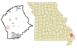
Scott County Missouri Incorporated and Unincorporated areas Vanduser Highlighted.svg
Location of Vanduser, Missouri
Coordinates: 36°59′28″N89°41′12″W / 36.99111°N 89.68667°W / 36.99111; -89.68667
Country United States
State Missouri
County Scott
Area
[1]
  Total0.13 sq mi (0.33 km2)
  Land0.13 sq mi (0.33 km2)
  Water0.00 sq mi (0.00 km2)
Elevation
[2]
312 ft (95 m)
Population
 (2020)
  Total183
  Density1,429.69/sq mi (549.90/km2)
Time zone UTC-6 (Central (CST))
  Summer (DST) UTC-5 (CDT)
ZIP code
63784
Area code 573
FIPS code 29-75724 [3]
GNIS feature ID2400047 [2]

Vanduser is a village in Scott County, Missouri, United States. The population was 267 at the 2010 census. The zip code is 63784.

Contents

History

Vanduser was laid out in 1895 when the railroad was extended to that point. [4] A post office called Vanduser has been in operation since 1898. [5] The community has the name of John Vanduser, the original owner of the town site. [4]

Geography

According to the United States Census Bureau, the village has a total area of 0.13 square miles (0.34 km2), all land. [6]

Demographics

Historical population
CensusPop.Note
1910 388
1920 326−16.0%
1930 236−27.6%
1940 29123.3%
1950 281−3.4%
1960 272−3.2%
1970 30612.5%
1980 3204.6%
1990 187−41.6%
2000 21716.0%
2010 26723.0%
2020 183−31.5%
U.S. Decennial Census [7]

2010 census

As of the census [8] of 2010, there were 267 people, 94 households, and 59 families living in the village. The population density was 2,053.8 inhabitants per square mile (793.0/km2). There were 102 housing units at an average density of 784.6 per square mile (302.9/km2). The racial makeup of the village was 91.01% White, 3.00% Black or African American, 0.37% Native American, 2.25% from other races, and 3.37% from two or more races. Hispanic or Latino of any race were 3.37% of the population.

There were 94 households, of which 34.0% had children under the age of 18 living with them, 35.1% were married couples living together, 22.3% had a female householder with no husband present, 5.3% had a male householder with no wife present, and 37.2% were non-families. 28.7% of all households were made up of individuals, and 16% had someone living alone who was 65 years of age or older. The average household size was 2.54 and the average family size was 3.03.

The median age in the village was 37.1 years. 33% of residents were under the age of 18; 7.9% were between the ages of 18 and 24; 18.3% were from 25 to 44; 25.8% were from 45 to 64; and 15% were 65 years of age or older. The gender makeup of the village was 53.6% male and 46.4% female.

2000 census

As of the census [3] of 2000, there were 217 people, 84 households, and 58 families living in the village. The population density was 1,643.0 inhabitants per square mile (634.4/km2). There were 92 housing units at an average density of 696.6 per square mile (269.0/km2). The racial makeup of the village was 99.54% White and 0.46% African American. Hispanic or Latino of any race were 0.92% of the population.

There were 84 households, out of which 35.7% had children under the age of 18 living with them, 48.8% were married couples living together, 15.5% had a female householder with no husband present, and 29.8% were non-families. 27.4% of all households were made up of individuals, and 15.5% had someone living alone who was 65 years of age or older. The average household size was 2.58 and the average family size was 3.15.

In the village, the population was spread out, with 23.5% under the age of 18, 9.7% from 18 to 24, 29.0% from 25 to 44, 24.0% from 45 to 64, and 13.8% who were 65 years of age or older. The median age was 38 years. For every 100 females, there were 88.7 males. For every 100 females age 18 and over, there were 82.4 males.

The median income for a household in the village was $25,417, and the median income for a family was $27,292. Males had a median income of $23,750 versus $14,531 for females. The per capita income for the village was $10,351. About 14.5% of families and 18.0% of the population were below the poverty line, including 18.2% of those under the age of eighteen and 32.3% of those 65 or over.
Related Research Articles

<span class="mw-page-title-main">Lyons, Michigan</span> Village in Michigan, United States

Lyons is a village in Ionia County in the U.S. state of Michigan. The population was 789 at the 2010 census. Most of the village is within Lyons Township. A small portion extends west into Ionia Township.

<span class="mw-page-title-main">West Line, Missouri</span> Village in Missouri, United States

West Line is a village in Cass County, Missouri. The population was 97 at the 2010 census. It is part of the Kansas City metropolitan area.

<span class="mw-page-title-main">Leslie, Missouri</span> Village in Missouri, United States

Leslie is a village in west central Franklin County, Missouri, United States. The population was 171 at the 2010 census.

<span class="mw-page-title-main">Pasadena Park, Missouri</span> Village in Missouri, United States

Pasadena Park is a village in St. Louis County, Missouri, United States. The population was 470 at the 2010 census. It is part of the Normandy School District, and is distinct from the city of Pasadena Hills.

<span class="mw-page-title-main">Westwood, Missouri</span> Village in Missouri, United States

Westwood is a village in west St. Louis County, Missouri, United States. The population was 316 at the 2020 census.

<span class="mw-page-title-main">Greenwood, Nebraska</span> Village in Nebraska, United States

Greenwood is a village in northwest Cass County, Nebraska, United States. The population was 595 at the 2020 census.

<span class="mw-page-title-main">Malmo, Nebraska</span> Village in Saunders County, Nebraska, United States

Malmo is a village in Saunders County, Nebraska, United States. The population was 94 at the 2020 census.

<span class="mw-page-title-main">Hanover, Ohio</span> Village in Ohio, United States

Hanover is a village in Licking County, Ohio, United States. The population was 1,270 at the 2020 census. The village lies along Ohio State Route 16.

<span class="mw-page-title-main">Berkey, Ohio</span> Village in Ohio, United States

Berkey is a village in Lucas County, Ohio, United States. The population was 275 at the 2020 census.

<span class="mw-page-title-main">Harbor View, Ohio</span> Village in Ohio, United States

Harbor View is a village in Lucas County, Ohio, United States. The population was 89 at the 2020 census.

<span class="mw-page-title-main">Limaville, Ohio</span> Census-designated place in Ohio, United States

Limaville is a census-designated place (CDP) and former village in Stark County, Ohio, United States. The population was 151 at the 2010 census. It is part of the Canton–Massillon Metropolitan Statistical Area.

<span class="mw-page-title-main">Wilmot, Ohio</span> Village in Ohio, United States

Wilmot is a village in southwestern Stark County, Ohio, United States. The population was 282 at the 2020 census. It is part of the Canton–Massillon metropolitan area.

<span class="mw-page-title-main">Clinton, Ohio</span> Village in Ohio, United States

Clinton is a village in southwestern Summit County, Ohio, United States. The population was 1,197 at the 2020 Census. It is part of the Akron metropolitan area.

<span class="mw-page-title-main">Clearview, West Virginia</span> Village in West Virginia, United States

Clearview is a village in Ohio County, West Virginia, United States. It is part of the Wheeling, West Virginia Metropolitan Statistical Area. The population was 565 at the 2010 census.

<span class="mw-page-title-main">Oliver, Wisconsin</span> Village in Wisconsin, United States

Oliver is a village in Douglas County, Wisconsin, United States. The population was 423 at the 2020 census.

<span class="mw-page-title-main">Poplar, Wisconsin</span> Village in Wisconsin, United States

Poplar is a village in Douglas County, Wisconsin, United States. The population was 603 at the 2010 census.

<span class="mw-page-title-main">South Wayne, Wisconsin</span> Village in Wisconsin, United States

South Wayne is a village in Lafayette County, Wisconsin, United States. The population was 489 at the 2010 census.

<span class="mw-page-title-main">Big Falls, Waupaca County, Wisconsin</span> Village in Wisconsin, United States

Big Falls is a village in Waupaca County, Wisconsin, United States. The population was 61 at the 2010 census.

<span class="mw-page-title-main">Wilton, Wisconsin</span> Village in Wisconsin, United States

Wilton is a village in Monroe County, Wisconsin, United States. The population was 504 at the 2010 census. The village is located partially within the Town of Wilton and partially within the Town of Wellington.

<span class="mw-page-title-main">Aniwa, Wisconsin</span> Village in Wisconsin, United States

Aniwa is a village in Shawano County, Wisconsin, United States. The population was 260 at the 2010 census. The village is located within the Town of Aniwa. U.S. Route 45 runs north–south through the village.

References

  1. "ArcGIS REST Services Directory". United States Census Bureau. Retrieved August 28, 2022.
  2. 1 2 U.S. Geological Survey Geographic Names Information System: Vanduser, Missouri
  3. 1 2 "U.S. Census website". United States Census Bureau . Retrieved January 31, 2008.
  4. 1 2 "Scott County Place Names, 1928–1945". The State Historical Society of Missouri. Archived from the original on June 24, 2016. Retrieved December 24, 2016.
  5. "Post Offices". Jim Forte Postal History. Retrieved December 24, 2016.
  6. "US Gazetteer files 2010". United States Census Bureau. Archived from the original on January 25, 2012. Retrieved July 8, 2012.
  7. "Census of Population and Housing". Census.gov. Retrieved June 4, 2015.
  8. "U.S. Census website". United States Census Bureau . Retrieved July 8, 2012.