The Cowpastures
When the First Fleet arrived in Sydney Cove in 1788, they found the soil unsuitable for farming and soon looked towards the heavy clay and loam soils of the Cumberland Plain (to the west) to sustain the colony. Early agricultural settlements were located on the rich alluvial soils of the Nepean, Hawkesbury and Georges River areas, as well as South Creek near St Marys and at the head of the Parramatta River, where the settlement of Rose Hill (later Parramatta) was established about six months after the fleet landed. A settlement at the Hawkesbury was established in 1794. [1]
By 1804 much of the Cumberland Plain had been settled and Governor King began to look for other regions in the colony for favourable arable land. The only suitable land within the Cumberland Plain was the area known as the Cowpastures, located in the southwestern corner. This area was named after the discovery in 1795 of cows from the first fleet which had wandered off into the bush. The Cowpastures had remained unoccupied due to the official decree that reserved the land for the wild cattle (to encourage their increase). [1]
In December 1803 Governor and Mrs King visited the Cowpastures for themselves and the Sydney Gazette reported that Mrs King was the first white lady to have crossed the Nepean River. The track to the Cowpastures led from Prospect and on 17 September 1805 James Meehan, under instructions from Governor King, commenced a survey of the track from Prospect to the Nepean Crossing and a rough road followed the marked line. This became known as Cowpasture Road, later the Hume Highway, most of which is today part of the Camden Valley Way. [1]
Several visits to the area by the colonial gentry took place at this time, which resulted in their desire to acquire some of this rich land for themselves. They saw the area as containing very good grazing land. Captain Henry Waterhouse described the area in a letter to John Macarthur in 1804 as follows: "I am at a loss to describe the face of the country other than as a beautiful park, totally divested of underwood, interspersed with plains, with rich luxuriant grass". [1]
Earlier Europeans had described "large ponds covered with ducks and the black swan, the margins of which were fringed with shrubs of the most delightful tints". The Europeans thought the flats were perfect for cattle and the hills would carry sheep. They admired the absence of underbush - probably achieved through Aboriginal burning off - and felt comfortable with a landscape that reminded them of an English gentleman's park. [1]
John Macarthur received the first land grant in the Cowpastures region in 1805 for his role in the early wool industry in the colony. Lord Camden rewarded him with 4,047 hectares (10,000 acres) and Macarthur chose the highly coveted Cowpastures for his grant, though Governor King tried to prevent him taking it. Macarthur also organised an 809-hectare (2,000-acre) grant for his friend Walter Davidson, who allowed Macarthur to use his land freely after Davidson returned to England. In this manner Macarthur controlled 19 kilometres (12 mi) of riverbank on the site where the wild cattle had first discovered the best pasture near Sydney. Later purchases and exchanges increased the Macarthur land there to over 10,927 hectares (27,000 acres), an endowment that Governor Macquarie greatly resented. [1]
Other early grants were in the Parishes of Minto and in adjoining Evan, Bringelly, Narellan and Cook. These all lay west of Parramatta. [2] [1]
Governor Macquarie drew up plans in 1820 for establishment of a town in the area, to be named Campbelltown after his wife Elizabeth's maiden name. With their forced return to England in 1822 these plans never came to fruition and it was not until the arrival of Governor Darling in 1827 that plans were again reinstated and the first settlers were allowed to take possession of their town land in 1831. In the early 1850s the railway line from Sydney to Goulburn was completed, with Campbelltown station opening in 1858. When Leppington House was offered for lease in 1865, one of its selling points was that it was near a railway. Campbelltown now provided easy access to Sydney and its markets and grew as the centre of the district. Although Camden was established in 1836, with no railway line it remained a small town. [1]
The large estates that flanked Cowpasture Road (later Camden Valley Way) and the Northern Road were run largely as sheep and cattle farms, with wheat and other grain crops being grown as well until the 1850s. The houses were often built on surrounding ridges or hills, providing sweeping views of the countryside and ensuring that any passing traveller could appreciate the owner's status by viewing their impressive country mansions from the road. This land use pattern of large farm estates and small towns, established in the nineteenth century, remained largely the pattern of development of the area up until the late 1990s. Aerial photographs of the area in 1947 show a rural landscape with some limited urban development on either side of the Camden Valley Way (then the Hume Highway). [3] [1]
Townson of Varroville
Robert Townson was born c. 1763 in Shropshire, developing interests in mineralogy and natural sciences young. Elected a non-resident member or Fellow of the Royal Society of Edinburgh in 1791, Physical class. He graduated M.D. at the University of Göttingen in 1795. Over 8–9 years he travelled extensively in Europe, from Trondheim in the north to Sicily, studying mineralogy, chemistry, botany, rural economy, technology, politics and ethics in the Universities of Göttingen, Vienna, Paris and Edinburgh. His "Travels in Hungary" was published in 1797, his 1798 "The Philosophy of Mineralogy" and a paper on the "perceptivity of Plants" was read in 1792 and included in the "Transactions" of the Linnaean Society. [4] [1]
In July 1807 Townson (d.1827), doctor of law and gentleman scientist arrived in Sydney. He had been elected a fellow of the Royal Society of Edinburgh and visited the universities of Copenhagen, Uppsala and Göttingen. In 1792 he contributed a paper to the Linnean Society of London on the "Perceptivity of Plants". "He was often at the home of Sir Joseph Banks and had there met William Paterson of the New South Wales Corps. His brother, Captain John Townson had served as a military officer in NSW before migrating to the colony as a settler in 1806, so he had ample opportunities to learn about the new settlement. Robert approached the British government for permission to settle in NSW. He was warmly received, informed that he was the type most urgently needed in the colony, promised land and indulgences, and allowed £100 to buy books and a laboratory for the colony. Dr Townson arrived in Sydney in the Young William on 7 July 1807. Proficient in all branches of natural science and also in Latin, Greek, German, French, he was the most eminent scholar in the young colony." [5] [1]
Townson arrived as a settler intending to establish himself as a pastoralist and trader in 1807. [6] He arrived with the instructions of the British Secretary of State to Governor Bligh to grant him 809 hectares (2,000 acres). Bligh refused to "locate the grant", but allowed him occupancy while awaiting instructions from England, which arrived in a letter of 31 December 1807. He established himself on a small estate of 31 hectares (77 acres) on the banks of the Georges River, living there for about five years, building a residence, stock yard, making and enclosing paddocks and making roads. He called this grant Towweery (Tom Uglys). [4] [1]
In January 1808 Townson, affronted at Bligh's delay over the granting of land, became 'an opponent of Bligh, and when rebellion took place some months later he was judged one of the principal six "who previously concerted together with Major Johnston the arrest and imprisonment of the Governor". He was present at the dinner at the officers' mess on the eve of the trial of John Macarthur which precipitated the revolt [and] he signed the requisition to Johnston to depose Bligh on 26 January 1808' He "soon fell out with the rebel administration. Johnston refused to give him the land he wanted at Emu Island, near Penrith; though he was given 809 hectares (2,000 acres) at Botany Bay near the present Blakehurst and twenty-eight government cattle, he claimed that only half the grant was of any use, and his long complaints against Bligh written in 1807 and 1808 were followed by another, equally querulous, in 1809 against his supplanters." [1] [5]
Overlooked in the grants made by Johnston in 1808, he received two grants from Foveaux in November 1808, both in the Botany Bay district, one of 30 hectares (75 acres), the other of 779 hectares (1,925 acres) around the present Oatley station, Mortdale, Penshurst and Hurstville.' [7] He had six assigned convicts. [4] [1]
In 1809, finding this [Botany Bay] land unsuitable he applied to William Paterson (who took over the government) for some adjacent land, of 194 hectares (480 acres). Since his land had poor pasture, he was obliged to send his flock away to other ground, and a few months before Macquarie's arrival he asked Paterson to allow him to exchange 324 hectares (800 acres) of his grant for some more open land "in a distant part of the colony". Paterson allowed him to take up 405 hectares (1,000 acres) for the 324 hectares (800 acres), giving him a total of 1,085 hectares (2,680 acres). This 405 hectares (1,000 acres) he chose was in the Minto district, and was the origin of Varro Ville. [4] [1]
James Meehan surveyed Varro Ville in August 1809, mentioning the hill of Bunbury Curran, a range, flats and hollows, hills and dales, ponds and ironbark trees, and the creek. A road was to be reserved on the south-east side. The grant was ready for delivery in November 1809'. [7] 'Townson later confirmed that he had immediately occupied the land, "employed a great deal of labour, and expended a great deal of money" in building a horse yard, cultivating a large garden, clearing and fencing paddock and making roads. [8] [1]
Macquarie on his arrival annulled by public proclamation the trials which had taken place during the usurpation (of Bligh). Grants of land and of stock and leases during the same period were revoked, as well as pardons and emancipations until he could tour all the districts and reconsider the grants. Townson was required to hand in his grants, which he did in 1810. Macquarie re-granted Townson 405 hectares (1,000 acres) at Bunbury Curran (809 hectares (2,000 acres) at Minto (405 hectares (1,000 acres) at "Bunbury Curran" as it was called) and Botany Bay were given in May 1811, despite Townson's objections about the amount of land required to be cultivated) [4] ), which Townson named Varro Ville after the Roman writer on agriculture, Marcus Terentius Varro (116-27 BC). [5] The stated reason was that Varro wrote extensively on agriculture and Townson was intent on making Varroville an exemplar of agricultural pursuit, which, according to his obituaries and official biography, [4] he achieved. [1]
In November 1810 Governor Macquarie toured the area (after having chosen the site of a town on George's River to which he gave the name Liverpool, after the Earl of that title [4] following the foundation of Liverpool, and writes in his journal of 8 November 1810: [1]
'[Finding] Mrs M had gone after returning home to see Dr Townson's farm and Bunbury Curran Hill we all followed her thither, and met her returning home again after having ascended the Hill, accompanied by her guide Mr. Meehan [Surveyor and owner of Macquarie Field]. The accounts given to me by Mrs M. of the beautiful prospect she had from the top of Bunbury Curran Hill induced me to ascend it, which I did on horseback, and was highly gratified with the noble extensive view I had from the top of it of the surrounding country. On my return from the Hill, we overtook Mrs M. on Dr Townson's farm, where we stopt for a few minutes to speak to the Doctor and look at a very ill chosen situation he has fixed on for the site of his new intended house'.
— Lachlan Macquarie, 8 November 1810.
Macquarie also commented in his journal that the farms of Townson and Andrew Thompson (St. Andrews farm, opposite Varroville) were "by far the finest soil and best pasturage I have yet seen in the colony; the grounds are beautiful and bounded by a large creek of brackish water called Bunbury Curran". [7] This difference of opinion on siting reflects the different characters of Macquarie and Townson - the former masterful and dashing, would have chosen a prominent site with an extensive view, the latter a scholar, preferring seclusion and proximity to oversight his crops and orchard. [4] [1]
Varro was a famous man of letters. Authors like Quintilian considered him "the most learned of the Romans". He wrote 74 works on 620 papyrus rolls on several subjects, but practically none have survived. His lost "On Libraries", in which he describes the organisation of a library and gives reasons for defining books as cultural artefacts, is one of the earliest discussions of the subject. [9] [1]
Since these grants were made on the customary condition that the land be cultivated and not sold for five years, Townson again felt aggrieved. He had been living on his capital for nearly four years and was afraid of penury. He sought permission to sell his land and return to England. In the end he remained but developed a psychopathic personality. He subordinated everything to the development of his farms, shut himself off from society and apparently did no scientific work in New South Wales. He became "singular" and eccentric and his rigid economy became a byword. He also nursed undue hostility towards all who had contributed to his critical situation; Macquarie described him as "discontented" and one of his leading opponents, though there is no evidence that Townson took part in intrigues against him'. [5] [1]
March 1812 'In March 1812 it would appear that Townson had not yet built his house. "This state of uncertainty (over the route of a public road St Andrews road, linking the Liverpool-Campbelltown road with the Cowpasture Road has prevented me from going on with my plans and I am still living, when at Bunbury Curran, in a very uncomfortable manner, as on this road depends where I shall place my house and make my inclosures. [10] [1]
After five years at his small grant of 31 hectares (77 acres) at Towweery (Tom Ugly's) on George's River, Townson had relocated to Minto by 1813 [7] and had made the "necessary establishment" there. He had managed to keep his six convicts for five years on the Government stores (when new settlers were normally allowed men on the stores for only 18 months), gaining extensions from Macquarie in 1810 and 1811. [4] [1]
Townson was associated with the development of the Australian wine industry, having been once known as 'the finest orchard in the Colony and a vineyard second only to Gregory Blaxland's' at Brush Farm, Ryde. He made very good use of his grant of 405 hectares (1,000 acres) at Minto. [6] "Black Muscardelle" grapes were cultivated and liberally distributed by merchant and viticulturist Robert Campbell. Robert Townson made a "passable sweet wine" from this grape at Bunbury Curran near 'Campbell-Town'and possibly also grew "Black Portugal" or 'Oporto'(i.e. Varroville). [11] [1]
In 1815 Townson supplied meat to the Sydney, Liverpool and Parramatta stores. In the 1818 Muster of stock for 1818 "Townson had 214 head of horned cattle and 1961 sheep He had twenty-two acres in wheat, eight in maize, four in barley, two in potatoes and two in garden and orchard." Following drought (and the caterpillar plague of 1819) Townson obtained a permit to pasture cattle across the mountains. In May 1821 he sent them south to a run that became Tiranna, Goulburn. [12] [1]
In October 1820 Townson offered property for sale " 405 hectares (1,000 acres) at Bunbury Curran, with a good house and offices and one of the best gardens in the colony. A great part is fenced in and divided into paddocks". [1] [13]
After Macquarie departed the colony, Townson began to take his rightful place in the community. In 1822 he became a foundation vice-president of the Agricultural Society and a member of its Horticultural and Stock Fund Committees. Varroville became a show place for its beauty, abundance and variety in orchard and garden; his vineyard was second only to that of Gregory Blaxland; his fine-wooled sheep and their clip were in great demand; his cattle were numerous and in the opinion of his contemporaries no single man had accomplished more in the rearing of stock'. [5] [1]
Timeline
- 1823 –'When the members of the Agricultural Society of New South Wales dined after the general Quarterly Meeting in Nash's Inn, Parramatta, at the beginning of 1823 the dessert was contributed from the gardens of Dr Townson and Captain Piper. "It consisted of no fewer than 18 kinds of fresh fruit, and 4 of dried; among which were the banana, the Orlean plum, the green gage, the real peach, the cat-head apple, and a peculiarly fine sort of musk melon. " 'Next to Gregory Blaxland, Townson was regarded as having 'most successfully and most extensively given his attention to the vine.' [14] [1]
- 1825 –A notice regarding the theft of grain from Townson's farm mentions a granary. [15] [1]
- 1827 –Townson died at Varroville on 27 June 1827 and was buried at St John's Cemetery, Parramatta. A bachelor, he left his fortune to his brother, Captain John Townson of Van Diemen's Land, to two nieces residing in England and to his nephew, Captain John Witts, R.N. A portrait, attributed to Augustus Earle is in the Mitchell Library. [5] By the time of his death, Varro Ville had become a show place for its beauty, abundance and variety in orchard and garden: his vineyard was second only to that of Gregory Blaxland (at Brush Farm, Ryde); his fine-wooled sheep and their clip were in great demand; his cattle were numerous and in the opinion of his contemporaries "no single man had accomplished more in the rearing of stock". [16] [1]
- 1829 –Varroville was acquired by Thomas Spencer Wills (1800-1836), the first Australian born Justice of the Peace and a founder of the Bank of NSW. One of his sisters married Dr William Redfern (1774 - 1833) of nearby Campbellfield, a major landowner in the area, while another married Henry Colden Antill (1779 - 1852) of Jarvisfield, Picton. [1]
- 1832 –The New South Wales Calendar and General Post Office Directory 1832 refers to "the residence of the late Dr Townson, now the property of Thomas Wills, Esq. This place is celebrated for a Garden and Vinery.". [17] [1]
- Early 1837 –Varroville was acquired by explorer, Captain Charles Sturt (1795-1869), who "described himself as "an enthusiastic horticulturalist". Writing to his brother William in Calcutta in 1835 when he was planning the purchase of a property, Sturt begged for fruits, plants, bulbs or seeds, "the rarer the better"." [18] Sturt established dams and modified watercourses, maintained the thriving kitchen garden, orchard and vineyard and took a keen interest in the birdlife at Varroville. He later cited Varroville as a model of water conservation during his term as Assistant Commissioner of Lands in South Australia. [19] [1]
- In 1838 –'On another occasion, in Sturt's second home in Varroville, the powers of native trackers were again called into play. Here in 1838 he was visited by the bird-artist, John Gould, who greatly admired Sturt's large original collection of Australian Psittacidae [parrots] in water-colour, for which he offered on the spot a large sum. But these paintings had been the delight of Sturt's leisure; he was devoted to ornithology and had collected rare specimens at great trouble and risk, and at no price would he part with his folio. It is supposed that Gould's remarks must have drawn the attention of some dishonest workman to the value of the drawings, for soon afterward the military chest in which they were kept disappeared and was never again seen. Natives put upon the scent found military accoutrements and other articles thrown out of the same chest, so that drawings were clearly the object of the theft' [20] [1]
- Sturt in a speech at a dinner in honour of Governor Gawler, 10 January 1840 urged South Australians to store water. 'On my farm at Varroville, until labour and skill were exerted, one only of many channels held water, and that was brackish. When I passed that farm, every paddock had its proper water-hole. In a severe drought I not only fed 180 head of stock on 405 hectares (1,000 acres) (of which 350 was under cultivation), but I permitted 19 families to supply themselves from my tanks' [21] Turner, male convict servant as cook rescued the elder Sturt son from drowning in a pond or dam. [22] [1]
- 'But no forethought could avert the widespread ruin from such a drought that prevailed between 1836 and 1839. Not even Sturt's waterholes could satisfy all demands or supplement the failing pasture. His hay-crop in 1838 was better than that of his neighbours. But stock were quite at a discount. Nor could wool be sent to Sydney for want of water by the way. The lines of road were unwholesome from the number of cattle and horses that dropped dead upon them. Just when the farmers of New South Wales were reduced to their lowest ebb their hopes were revived by the new settlement in South Australia.' [23] [1]
- In 1839 –Sturt's sale notice for the property appeared in the Australian, "The cottage is convenient and an excellent kitchen and wash house have been added to it. The outhouses consist of stables, coach house, verandah, dairy, store, barn etc. and there is a well-stocked garden and vineyard". 'Sturt apparently sold his uncleared grant 2,023 hectares (5,000 acres) [at Ginningdera, [sic] Canberra] at its auction value with the proceeds bought a small but ready- fenced property at Varroville, which on his sudden departure for South Australia in 1839 [to take up the post of Surveyor-General], he was forced to sell at so great a loss that the final outcome of the grant dwindled to less than £450.' [24] [1]
- November 1839 –Varroville acquired by James Raymond, the first Postmaster General of the Colony of New South Wales. Raymond introduced the world's first pre-paid postage in November 1838, anticipating the British penny postage in 1840. Raymond entertained extensively at Varroville. "He was also a keen follower of horse-racing and owned several horses himself." [5] An oil on canvas horse portrait by Edward Winstanley (1820-1849) "Nazeer Farrib", A High Caste Arab, the property of James Raymond Esq of Varroville is in the State Library of NSW collection (ML282). [1]
- Raymond died at Darlinghurst on 29 May 1851 aged 65 and his daughter Aphra (Aphrasia Kemmis) and her family lived rent-free at Varroville according to the terms of his will. [25] Raymond featured as the fictional postmaster "Raymond Plenty" in architect and writer William Hardy Wilson's romance "The Cowpasture Road", Sydney. [1] [26]
- 1858 –'In 1858 Raymond's sons sold the property to the late George Taylor Rowe, who mortgaged it to H. H. Browne. Browne defaulted on his mortgage during 1859 and Rowe claimed possession of the house.' [25] [1]
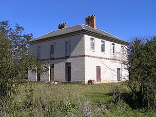
- 27 April 1858 –Architects, Weaver & Kemp of 160 Pitt Street, Sydney advertise for tenders from masons "for laying the Foundations of a House at Varroville, near Campbelltown. Plan and specification, and further particulars may be ascertained on application to the undersigned". [27] William Weaver (1828-) was a former Colonial Architect (1854- April 1856), formerly Edmund Blacket's clerk of works (while Blacket was Colonial Architect) and had trained under Isambard Kingdom Brunel, the Franco-British civil engineer (1806-1859). Weaver & Kemp also designed Jarvisfield, Picton and Burrundulla, Mudgee. The new house was built on the site of the previous house, retaining an early stone chimneypiece (with evidence of a former kitchen crane) and hearthstone from the previous house. The bread oven chimney has been capped before the shingling of the roof above it. [1]
- c. 1859 –Following Rowe's death Varroville sold to Justice Alfred Cheeke for £4,500. Cheeke (1810-1876) bred and trained race horses at Varroville (including "Clove" which won the first Australian Jockey Club Derby in 1865), established and maintained a private racecourse on the flat below the house. He was elevated to the Supreme Court of New South Wales in 1865. An oval form close to today's F5 freeway has been identified in aerial photographs as possibly Cheeke's racetrack. [1]
- 1876 –Varroville, the estate of the late Justice Cheeke was advertised for sale by Richardson & Wrench and purchased by grazier M. Suttor. 'Varroville House is a commodious family residence, recently erected by the late proprietor. It is built of brick and stone, is nearly surrounded by verandahs and contains the following accommodation:- hall, 8 feet wide: drawing and dining rooms each 20 x 16: 6 bedrooms, two of which are 20 x 16: dressing room with well-arranged superior bath: patent closet: stove, kitchen with oven, servants hall, wine cellar, laundry with copper, larder, pantry, china closet & c. There is an additional residence of six apartments a few yards from the above. Both are surrounded by tastefully laid out gardens and shrubbery, are erected on a beautiful elevation, and approached by a fine carriage drive from the main road. [1]
- An abundant supply of water is obtained from an immense underground reservoir, which receives the roof water. A pump forces the water on to the premises, supplying the bathroom &c.; The outbuildings are very numerous and comprise gardener's house, barn, cow-houses, calf-pens, dairy, piggery with coppers, stock and drafting yards, complete ranges of stabling, including a number of well-finished spacious loose boxes for blood stock.'. [28] [1]
- This house is the third built on the estate. [29] [1]
- 1885 –Suttor sold Varroville to Sydney solicitor, Thomas Salter. Salter leased it to H. Pockley for dairying. [1]
- 1906 –Salter sold Varroville to Reginald Thomas. [30]
- 1912 –Thomas sold Varroville to W. H. Staniforth, dairyman of St Andrews. [1]
- 1923 –Staniforth leased Varroville to Percy, Austin and Arthur Smith (Smith Bros), dairymen of Concord. They operated dairies at Robin Hood Farm (Ingleburn, also NSW State Heritage Register-listed) and Varroville until 1958, running their own dairy herd and purchasing milk from local farmers'. [1] [31]
- 1929 –George Smith purchased Varroville. Varroville was subsequently owned by Robert Stanley Thompson. [1]
- In 1950 –Thompson sold the property to grazier, William Forest Ross who sold it to former engineer and owner of Gatwick Airport in England, and former RAF 601 Squadron (Auxiliary) member, Alfred L M (Morris) and wife Cherry Jackaman (1911-2011). Changes made by the Jackamans include enlarging the drawing room (to the former footprint of the northern veranda and extending the terrace on this side), relocating the access to the cellar, building the colonnade at the western end of the courtyard (on the site of a picket fence), installing the fountain against the northern range wall, building the swimming pool, change rooms, gazebo and "crazy paving" the surrounds of these. The old back drive from St Andrew's Road became the principal entry. [1]
- In 1960 –Cherry Jackaman joined Dame Helen Blaxland on the Women's Committee of the National Trust (NSW). Jackaman chaired this committee from 1964–67 and by 1968 had raised more than $100,000, which was directed to Experiment Farm Cottage, Lindesay and the St. Matthews Anglican Church at Windsor Appeal. She also presided over the initiation of house inspections designed to recognise important heritage properties within NSW and pioneered discounting of building supplies for restoring listed properties. [32] [1]
- 1964 –the Jackamans opened Varroville as part of house inspections by the National Trust of Australia (NSW) Women's Committee (another opening was held in 1968). The tour brochures indicated the Jackamans considered the house to predate the 1850s, with the verandas and marble chimneypieces described as later additions. Mrs Jackaman's guests included her friend, the British actress Vivienne Leigh, Sir Laurence Olivier and Princess Michael of Kent. [1]
- Cherry Jackaman resumed the chair of the Women's Committee of the National Trust (NSW) in 1970 for three years and was elected unopposed as the first female president of the National Trust of Australia (NSW) in 1977, a position she held until 1981. [32] In the early 1970s the house lot was subdivided from its context onto 3.1 hectares (7.7 acres). The date of subdivision of the land occupied by Sweeney's Riding Ranch from land owned by the Jackaman family is unknown. [1]
- In 1973 –the Campbelltown Local Environmental Plan's zoning of this section (Central Hills) of what has become known as its "Scenic Hills" was zoned, predominantly in the case of Varroville's setting, 7d1 - Environment Protection - Scenic, some zoned 6c - Open Space (Regional). [1]
- In the 1980s –land was resumed from the estate for the M5 Motorway. [1]
- In 1990 –Mrs Jackaman presented Varroville homestead and 3.1 hectares (7.7 acres) (i.e. without its outbuildings) to the National Trust of Australia (NSW). [1]
- In 1991 –the property was sold to fund National Trust of Australia (NSW) debt. [32]
- In 1992 –The National Trust (NSW) commissioned a conservation plan for Varroville from architects, Orwell and Peter Phillips and sold Varroville to architects, Keith and Virginia Pearson-Smith. [33] [1]
- 2002 –Varroville was acquired by John Moutsopoulos and Vanessa Seary. [1]
- 2006 –Varroville was acquired by Peter Gibbs and Jacqui Kirkby. [1]
- May 2007 –The Cornish Group acquired approximately 113 hectares (280 acres) adjoining and surrounding Varroville from Mrs Jackaman's daughters. Prior to this the Cornish Group were reported to have taken out an option to buy the adjoining Sweeney's Scenic Riding Ranch (not owned by the Jackaman family), giving them approximately 320 hectares (800 acres) of the original 400 hectares (1,000 acres) of Robert Townson's 1810 estate. [33] [1]
- In 2009 –Cherry Jackaman was awarded the OAM. Morris died in 1980, Cherry moving to Double Bay. [32] [1]