Wachusett Aqueduct | |
|---|---|
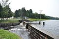
 Wachusett Aqueduct at Northborough spanning over the Assabet River | |
| Coordinates | 42°23′57″N71°41′22″W / 42.39917°N 71.68944°W |
| Begins | Wachusett Reservoir |
| Ends | Marlborough, Massachusetts |
| Official name | Wachusett Aqueduct |
| Maintained by | MWRA |
| Characteristics | |
| Total length | 9 mi (14.5 km) |
| Width | 12 ft (3.7 m) |
| Height | 11 ft (3.4 m) |
| Capacity | 400 cu ft/s (11.33 m3/s) |
| History | |
| Construction start | 1897 |
| Opened | 1905 |
Wachusett Aqueduct Linear District | |
| Built | 1896 |
| Architect | Frederick P. Stearns |
| MPS | Water Supply System of Metropolitan Boston MPS |
| NRHP reference No. | 89002276 [1] |
| Added to NRHP | January 18, 1990 |
| Location | |
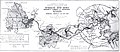
 Interactive map of Wachusett Aqueduct | |
The Wachusett Aqueduct is a secondary aqueduct that carries water from the Wachusett Reservoir to the John J. Carroll Water Treatment Plant at Walnut Hill in Marlborough, Massachusetts. It is part of the public water supply system for the communities of Greater Boston that are served by the Massachusetts Water Resources Authority (MWRA), which manages the aqueduct. The aqueduct serves as a standby backup to the Cosgrove Tunnel.