Wasagamack First Nation is an Oji-Cree First Nation band government in Manitoba, Canada. As of December 2014 the registered population of the Wasagamack First Nation was 2,017, of which 1,823 lived on their own reserve.
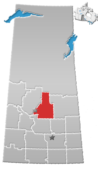
Division No. 15 is one of eighteen census divisions in the province of Saskatchewan, Canada, as defined by Statistics Canada. It is located in the north-central part of the province. The most populous community in this division is Prince Albert.

St. Theresa Point First Nation is a First Nations community in northern Manitoba. It has 3 reserves in total, the largest and most populated of which is St. Theresa Point, which is bordered by the unorganized portion of Division No. 22, Manitoba, and by the Wasagamack First Nation.
The Lac La Ronge Indian Band is a Woodland Cree First Nation in northern Saskatchewan, it is the largest Cree band government in Canada and the largest First Nation in Saskatchewan. The administrative centre of the Lac La Ronge Indian Band is located in La Ronge.

Black Lake is a Denesuline First Nations band government in the boreal forest of northern Saskatchewan, Canada. It is located on the northwest shore of Black Lake where the Fond du Lac River leaves the lake to flow to Lake Athabasca.

Namur Lake 174B is an Indian reserve of the Fort McKay First Nation in Alberta, located within the Regional Municipality of Wood Buffalo. It is 105 kilometres northwest of Fort McMurray.
Wahpeton Dakota Nation is a Dakota First Nation in Saskatchewan, Canada. Their reserves include:

Peerless Trout 238 is an Indian reserve of the Peerless Trout First Nation in Alberta, located within the Municipal District of Opportunity No. 17.

Bittern Lake 218 is an Indian reserve of the Lac La Ronge Indian Band in Saskatchewan. It is 8 kilometres east of Prince Albert National Park.

The Chief Joseph Custer Reserve is an Indian reserve of the Peter Ballantyne Cree Nation in Saskatchewan. It is located in the city of Prince Albert, making it an urban reserve.

Chief Philip Morin 232 is an Indian reserve of the Peter Ballantyne Cree Nation in Saskatchewan. It is located inside the city of Prince Albert, making it an urban reserve.

Flying Dust 105D is an Indian reserve of the Flying Dust First Nation in Saskatchewan.
Flying Dust 105E is an Indian reserve of the Flying Dust First Nation in Saskatchewan.

Gladue Lake 105B is an Indigenous reserve of the Flying Dust First Nation in Saskatchewan, Canada. It is in Township 63, Range 15, west of the Third Meridian, in the Jarvis Lake area.

Little Hills 158B is an Indian reserve of the Lac La Ronge Indian Band in Saskatchewan. It is 8 miles southwest of La Ronge, and on the south-east shore of Bigstone Lake.

Little Red River 106C is an Indian reserve of the Lac La Ronge Indian Band in Saskatchewan. It is 34 kilometres north of Prince Albert. In the 2016 Canadian Census, it recorded a population of 354 living in 88 of its 98 total private dwellings. In the same year, its Community Well-Being index was calculated at 48 of 100, compared to 58.4 for the average First Nations community and 77.5 for the average non-Indigenous community.
The Muskoday Reserve is an Indian reserve of the Muskoday First Nation in Saskatchewan. It is 19 kilometres southeast of Prince Albert. In the 2016 Canadian Census, it recorded a population of 647 living in 205 of its 217 total private dwellings. In the same year, its Community Well-Being index was calculated at 64 of 100, compared to 58.4 for the average First Nations community and 77.5 for the average non-Indigenous community.

Muskoday 99B is an Indian reserve of the Muskoday First Nation in Saskatchewan.

Wahpaton 94A is an Indian reserve of the Wahpeton Dakota Nation in Saskatchewan. It is 10 kilometres north of Prince Albert. In the 2016 Canadian Census, it recorded a population of 309 living in 70 of its 80 total private dwellings. In the same year, its Community Well-Being index was calculated at 58 of 100, compared to 58.4 for the average First Nations community and 77.5 for the average non-Indigenous community.
