Warren's Gore, Vermont

Last updated
Warren's Gore, Vermont
Warrens gore vt highlight.png
Located in Essex County, Vermont
Country United States
State Vermont
County Essex County
Population
 (2020)
  Total2

Warren's Gore (or Warrens Gore or Warren Gore) is a gore in Essex County, Vermont, United States. The population was 2 at the 2020 census, [1] down from 4 at the 2010 census. In Vermont, gores and grants are unincorporated portions of a county which are not part of any town and have limited self-government (if any, as many are uninhabited). Warren's Gore is part of the Berlin, NH VT Micropolitan Statistical Area.

Contents

History

Warren's Gore was originally chartered to be part of the town of Warren on October 20, 1789. The charter provided for two tracts of land, one which became the town and the other which became the gore. They were almost 100 miles from each other, on opposite sides of the state. Why they were chartered together is still uncertain, but it is possible that this was due to the tract of land for the grant that became the town of Warren being smaller than most; the inclusion of the gore would therefore have been a tactic to increase the total land area. The tract that became the gore has been treated as separate from the town since its inception. The charter referred to the two tracts collectively as "a Township by the name of Warren". [2] [3]

While the place was known as Warren's Gore, including in Vermont state statutes, [4] the U.S. Board on Geographic Names eschews the use of apostrophes in geographic names, which may improperly imply personal possession. [5] This has led to the use of both Warrens Gore and Warren Gore as well. The Vermont Atlas and Gazetteer (Delorme, 9th ed., 1996) uses Warren Gore on the relevant map (p. 55) but also uses Warrens Gore (with no apostrophe) for the gore's entry in the index (p. 7).

Geography

According to the United States Census Bureau, the gore has a total area of 11.4 square miles (29.5 km2), of which 10.5 square miles (27.3 km2) is land and 0.81 square miles (2.1 km2), or 7.26%, is water. [6] The gore contains the majority of Norton Pond, the source of the Coaticook River, which flows north into Quebec. Less than one mile south of Norton Pond is the source of the Pherrins River, which flows south to Island Pond and is part of the Clyde River (Lake Memphremagog) watershed.

Vermont Route 114 passes through Warrens Gore, leading north to Norton and south to Island Pond.

Demographics

Historical population
YearPop.±%
1940 0    
1950 1    
1960 0−100.0%
1970 1    
1980 0−100.0%
1990 2    
2000 10+400.0%
2010 4−60.0%
2020 2−50.0%
[6] [7] [8] [9]

As of the census of 2000, there were 10 people, 4 households, and 4 families residing in the gore. The population density was 0.9 people per square mile (0.4/km2). There were 43 housing units at an average density of 3.9/sq mi (1.5/km2). The racial makeup of the gore was 100.00% white. [10]

There were 4 households, out of which 25.0% had children under the age of 18 living with them, 100.0% were married couples living together, and 0.0% were non-families. No households were made up of individuals, and none had someone living alone who was 65 years of age or older. The average household size was 2.50 and the average family size was 2.50. [10]

In the gore the population was spread out, with 20.0% under the age of 18, 30.0% from 25 to 44, 30.0% from 45 to 64, and 20.0% who were 65 years of age or older. The median age was 46 years. For every 100 females, there were 150.0 males. For every 100 females age 18 and over, there were 100.0 males. [10]

Related Research Articles

<span class="mw-page-title-main">Essex County, Vermont</span> County in Vermont, United States

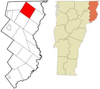
Essex County is a county located in the northeastern part of the U.S. state of Vermont. As of the 2020 census, the population was 5,920, making it the least-populous county in both Vermont and New England. Its shire town is the municipality of Guildhall. The county was created in 1792 and organized in 1800. Bordered by the Connecticut River next to New Hampshire, Essex County is south of the Canadian province of Quebec. It is the county with the lowest household-income in Vermont.

<span class="mw-page-title-main">Putnam, New York</span> Town in Washington County, New York, US

Putnam is a town in northern Washington County, New York, United States. It is part of the Glens Falls Metropolitan Statistical Area. The town population was 645 at the 2000 census. The town is named after Israel Putnam, a hero of the American Revolution.

<span class="mw-page-title-main">Glade Township, Warren County, Pennsylvania</span> Township in Pennsylvania, United States

Glade Township is a township in Warren County, Pennsylvania, United States. The population was 2,039 at the 2020 census, down from 2,308 at the 2010 census. 2,319 at the 2000 census.

<span class="mw-page-title-main">Buels Gore, Vermont</span> Unincorporated portion of Chittenden County Vermont

Buels Gore is a gore in Chittenden County, Vermont, United States. The population was 29 at the 2020 census, down from 30 in 2010. In Vermont, gores and grants are unincorporated portions of a county which are not part of any town and have limited self-government.

<span class="mw-page-title-main">Averill, Vermont</span> Town in Vermont, United States

Averill is an unincorporated town in Essex County, Vermont, United States. The town was named for Samuel Averill, a landholder. The town was never formally incorporated, having never gained a large enough permanent population. The population was 21 at the 2020 census. The town's affairs are handled by the Unified Towns & Gores of Essex County. It is part of the Berlin, New Hampshire Vermont Micropolitan Statistical Area.

<span class="mw-page-title-main">Bloomfield, Vermont</span> Town in Vermont, United States

Bloomfield is a town in Essex County, Vermont, United States. The population was 217 at the 2020 census. It is part of the Berlin, New Hampshire-Vermont Micropolitan Statistical Area.

<span class="mw-page-title-main">Brighton, Vermont</span> Town in Vermont, United States

Brighton is a town in Essex County, Vermont, United States. The population was 1,157 at the 2020 census. The town was named "Gilead" in its original grant in 1780. The town was sold to a group consisting primarily of soldiers commanded by Colonel Joseph Nightingale and subsequently named "Random". The town's name was finally changed by the legislature to "Brighton" in 1832. The Brighton village of Island Pond gets its name from the Abenaki word Menanbawk, which literally means island pond.

<span class="mw-page-title-main">Concord, Vermont</span> Town in Vermont, United States

Concord is a town in Essex County, Vermont, United States. The population was 1,141 at the 2020 census. It is part of the Berlin, NH–VT Micropolitan Statistical Area.

<span class="mw-page-title-main">Ferdinand, Vermont</span> Town in Vermont, United States

Ferdinand is a town in Essex County, Vermont, United States. It was named after German Prince Karl Wilhelm Ferdinand of Brunswick-Lunenburg. Although incorporated, it was never formally organized since it never gained a sufficiently large permanent population. Its population was 16 at the 2020 census and was highest in 1910, with 213. It is managed by the Unified Towns & Gores of Essex County. It is part of the Berlin, NH–VT Micropolitan Statistical Area.

<span class="mw-page-title-main">Guildhall, Vermont</span> Town in Vermont, United States

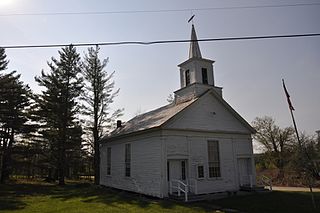
Guildhall is a town in and the shire town of Essex County, Vermont, United States. As of the 2020 census, the population was 262. According to a large sign in the town center, it is the only town in the world so named. The name derives from a meeting house on the square called the Guildhall.

<span class="mw-page-title-main">Lemington, Vermont</span> Town in Vermont, United States

Lemington is a town in Essex County, Vermont, United States. The population was 87 as of the 2020 census. It is part of the Berlin, NH–VT Micropolitan Statistical Area.

<span class="mw-page-title-main">Lewis, Vermont</span> Town in Vermont, United States

Lewis is a town in Essex County, Vermont, United States. The town was named for landholders Nathan, Sevignior, and Timothy Lewis. Although incorporated by the state, the town was never formally organized, since it never gained a sufficiently large permanent population. For most of the 20th century, the town had a total population of zero. It reported a population of 2 at the 2020 census; however it is possible due to the town sharing a census block with nearby towns and gores and the introduction of differential privacy in for the 2020 census, that the actual population remained at 0. Indeed, 100% of the town's land that is not federally protected is owned by a single logging company, Weyerhaeuser. The town's affairs are handled by the Unified Towns & Gores Of Essex County.

<span class="mw-page-title-main">Lunenburg, Vermont</span> Town in Vermont, United States

Lunenburg is a town in Essex County, Vermont, United States. The population was 1,246 at the 2020 census, the most populous in Essex County. Lunenburg contains the villages of Lunenburg and Gilman and hamlets of West Lunenburg, South Lunenburg, and Mill Village, and is part of the Berlin, NH–VT Micropolitan Statistical Area.

<span class="mw-page-title-main">Norton, Vermont</span> Town in Vermont, United States

Norton is a town in Essex County, Vermont, United States. The population was 153 at the 2020 census. It is part of the Berlin, NH–VT Micropolitan Statistical Area. It is located on the Canada–US border, immediately south of Stanhope, Quebec.

<span class="mw-page-title-main">Warner's Grant, Vermont</span> Unincorporated parcel of land in Essex County,Vermont, United States

Warner's Grant is a gore located in Essex County, Vermont, United States. At the 2020 Census, the grant had a total population of 0. In Vermont, gores and grants are unincorporated portions of a county which are not part of any town and have limited self-government. Warner's Grant is named after Seth Warner, a leader of the Green Mountain Boys.

<span class="mw-page-title-main">Eden, Vermont</span> Town in Vermont, United States

Eden is a town in Lamoille County, Vermont, United States. The population was 1,338 at the 2020 census.

<span class="mw-page-title-main">Wolcott, Vermont</span> Town in Vermont, United States

Wolcott is a town in Lamoille County, Vermont, United States. The town was named for General Oliver Wolcott, a signer of the Declaration of Independence. The population was 1,670 at the 2020 census.

<span class="mw-page-title-main">Warren, Vermont</span> Town in Vermont, United States

Warren is a town in Washington County, Vermont, United States. The population was 1,977 at the 2020 census. The center of population of Vermont is located in Warren. It is set between the two ranges of the Green Mountains, with approximately 25% of the township within the boundaries of the federal Green Mountain National Forest.

<span class="mw-page-title-main">Halifax, Vermont</span> Town in Vermont, United States

Halifax is a town in Windham County, Vermont, in the United States. As of the 2020 census, the town population was 771.
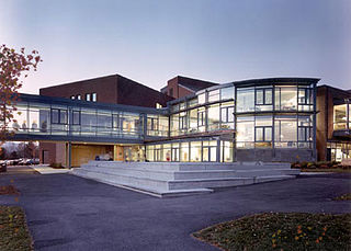
<span class="mw-page-title-main">Averys Gore, Vermont</span> Unincorporated parcel of land in Essex County, Vermont, United States

Averys Gore is a gore located in Essex County, Vermont, United States.

References

  1. "Census - Geography Profile: Warren's gore, Essex County, Vermont". United States Census Bureau . Retrieved December 25, 2021.
  2. State Papers of Vermont, Volume Two: Charters Granted by the State of Vermont, Vermont Secretary of State, 1922, pp. 207–9, also p. 362.
  3. "Then Again: A use for Vermont's leftover bits and pieces". VTDigger. 2017-03-26. Retrieved 2022-12-13.
  4. E.g., Title 17, Chapter 34, Section 1893; Title 24, Chapter 117, Section 4341(e).
  5. "How Do I?". www.usgs.gov. Retrieved 2020-01-08.
  6. 1 2 "Geographic Identifiers: 2010 Census Summary File 1 (G001): Warren's gore, Essex County, Vermont". American Factfinder. U.S. Census Bureau. Archived from the original on February 13, 2020. Retrieved April 8, 2016.
  7. "Vermont: 2000 - Population and Housing Unit Counts" (PDF). Archived from the original (PDF) on 2022-01-20. Retrieved 2021-12-25.
  8. "Population and Housing Unit Counts - Vermont" (PDF). Archived from the original (PDF) on 2004-11-09.
  9. "Number of Inhabitants" (PDF). Retrieved 2023-11-15.
  10. 1 2 3 "U.S. Census website". United States Census Bureau . Retrieved 2008-01-31.

See also

44°55′00″N71°53′00″W / 44.91667°N 71.88333°W / 44.91667; -71.88333