Fond du Lac Dene Nation is a Dene First Nation located in the boreal forest area of northern Saskatchewan, Canada. The main settlement is Fond-du-Lac, situated on the east side of Lake Athabasca. It is a remote fly-in community. The population in 2011 was 874, mainly of Dene and Métis descent. 705 residents selected Dene as their mother tongue in 2011.
BulyeaBUUL-yay is a village in the Canadian province of Saskatchewan within the Rural Municipality of McKillop No. 220 and Census Division No. 6.
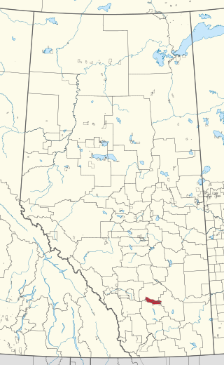
Siksika 146 is a First Nations reserve of the Siksika Nation in southern Alberta, Canada. It is 87 km (54 mi) southeast of Calgary at an elevation of 857 m (2,812 ft).

Red Earth Cree Nation is a Cree community in Saskatchewan, Canada. It is located 225 kilometres (140 mi) northeast of Prince Albert. The main settlement of Red Earth is located on the Carrot River and accessed by Highway 55. Nearby to the east is the Shoal Lake First Nation.

Woodland Cree 228 is an Indian reserve of the Woodland Cree First Nation in Alberta, located within Northern Sunrise County. It is 75 kilometres northeast of Peace River. In the 2016 Canadian Census, it recorded a population of 150 living in 33 of its 36 total private dwellings.

Amisk Lake 184 is an Indian reserve of the Peter Ballantyne Cree Nation in Saskatchewan.

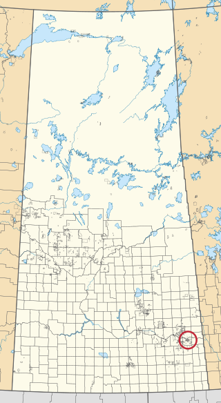
Amiskosakahikan 210 is an Indian reserve of the Peter Ballantyne Cree Nation in Saskatchewan. It is 11 kilometres southwest of Creighton.

Birch Portage 184A is an Indian reserve of the Peter Ballantyne Cree Nation in Saskatchewan. It is 30 miles northwest of Flin Flon.

Budd's Point 20D is an Indian reserve of the Cumberland House Cree Nation in Saskatchewan. It is 85 kilometres south of Flin Flon.

Muskeg Lake 102 is an Indian reserve of the Muskeg Lake Cree Nation in Saskatchewan. It is 93 kilometres north of Saskatoon. In the 2016 Canadian Census, it recorded a population of 274 living in 104 of its 112 total private dwellings. In the same year, its Community Well-Being index was calculated at 57 of 100, compared to 58.4 for the average First Nations community and 77.5 for the average non-Indigenous community.
Muskeg River 20C is an Indian reserve of the Cumberland House Cree Nation in Saskatchewan. It is in Township 58, Range 5, west of the Second Meridian.

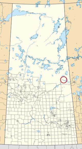
Nakiskatowaneek 227 is an Indian reserve of the Peter Ballantyne Cree Nation in Saskatchewan. It is near Pelican Junction.

Ocean Man 69I is an Indian reserve of the Ocean Man First Nation in Saskatchewan. In the 2016 Canadian Census, it recorded a population of 5 living in 1 of its 1 total private dwellings.

Ochapowace 71-51 is an Indian reserve of the Ochapowace Nation in Saskatchewan. It is 6 kilometres south of Atwater. In the 2016 Canadian Census, it recorded a population of 0 living in 0 of its 0 total private dwellings.
Ochapowace 71-54 is an Indian reserve of the Ochapowace Nation in Saskatchewan. It is 16 kilometres southeast of Bird's Point. In the 2016 Canadian Census, it recorded a population of 0 living in 0 of its 0 total private dwellings.

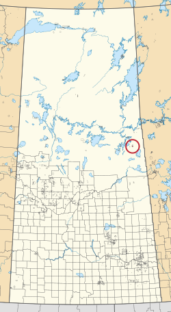
Pelican Narrows 184B is an Indian reserve of the Peter Ballantyne Cree Nation in Saskatchewan. It is 80 kilometres northeast of Flin Flon. In the 2016 Canadian Census, it recorded a population of 1869 living in 327 of its 350 total private dwellings. In the same year, its Community Well-Being index was calculated at 34 of 100, compared to 58.4 for the average First Nations community and 77.5 for the average non-Indigenous community.

Pelican Narrows 206 is an Indian reserve of the Peter Ballantyne Cree Nation in Saskatchewan. It is 5 kilometres south of Pelican Narrows.

Pine Bluff 20A is an Indian reserve of the Cumberland House Cree Nation in Saskatchewan. It is 60 miles southwest of Flin Flon, and on the north shore of the Saskatchewan River.

Pine Bluff 20B is an Indian reserve of the Cumberland House Cree Nation in Saskatchewan. It is 60 kilometres southwest of Flin Flon, and on the north shore of the Saskatchewan River.