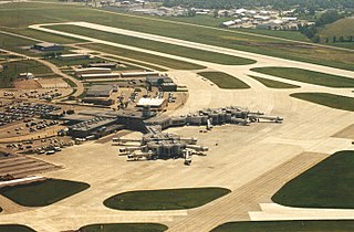
Green Bay–Austin Straubel International Airport is a county-owned public-use airport in Brown County, Wisconsin, United States, which serves Northeastern Wisconsin. It is the fourth busiest of eight commercial service airports in Wisconsin in terms of passengers served. The airport is located 7 nautical miles southwest of downtown Green Bay, in the village of Ashwaubenon.

Lawrence J. Timmerman Airport, known locally as Timmerman Field, is an airport in Milwaukee, Wisconsin, United States, owned by Milwaukee County. Located 5 miles (8 km) northwest of the city center, it is used mainly for general or private aviation. It is included in the Federal Aviation Administration (FAA) National Plan of Integrated Airport Systems for 2025–2029, in which it is categorized as a regional reliever airport facility.

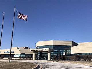
Central Wisconsin Airport, referred to as "C-Way", is a public airport located 3 nautical miles southeast of the central business district of Mosinee, in Marathon County, Wisconsin, United States. It is owned by Marathon County and Portage County. It is included in the Federal Aviation Administration (FAA) National Plan of Integrated Airport Systems for 2025–2029, in which it is categorized as a non-hub primary commercial service facility. It is the fifth busiest of eight commercial airports in Wisconsin in terms of passengers served.
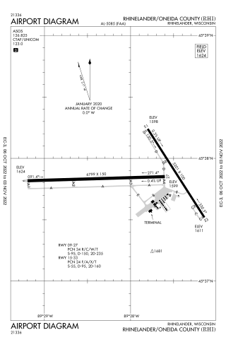
Rhinelander–Oneida County Airport is a public use airport located 2 nautical miles southwest of the central business district of Rhinelander, a city in Oneida County, Wisconsin, United States. The airport is owned by the city and county. It is primarily used for general aviation and is also served by two commercial airlines.

Watertown Municipal Airport is a public use airport located in and owned by the city of Watertown, in Jefferson County, Wisconsin, United States. It is included in the Federal Aviation Administration (FAA) National Plan of Integrated Airport Systems for 2025–2029, in which it is categorized as a regional general aviation facility.

Kenosha Regional Airport is a city-owned public-use airport located four nautical miles (7 km) west of the central business district of Kenosha, a city in Kenosha County, Wisconsin, United States.
Waukesha County Airport/Crites Field is a public use airport located two miles (3 km) north of the central business district of Waukesha, a city in Waukesha County, Wisconsin, United States. It is owned and operated by Waukesha County. It is included in the Federal Aviation Administration (FAA) National Plan of Integrated Airport Systems for 2025–2029, in which it is categorized as a national relief airport.
Sparta/Fort McCoy Airport is a public and military use airport located in Monroe County, Wisconsin, United States, three nautical miles (6 km) northeast of Sparta. The airport is used heavily by the U.S. Army, accounting for 75% of traffic operations, primarily transient military aircraft supporting operations at nearby Fort McCoy, which is a major training facility. It is included in the Federal Aviation Administration (FAA) National Plan of Integrated Airport Systems for 2025–2029, in which it is categorized as a local general aviation facility.

Fond du Lac County Airport is a county-owned public-use airport located 1 mile (2 km) west of the central business district of Fond du Lac, Wisconsin, a city in Fond du Lac County, Wisconsin, United States. It is included in the Federal Aviation Administration (FAA) National Plan of Integrated Airport Systems for 2025–2029, in which it is categorized as a regional general aviation facility. The airport is home to EAA chapter 572.

Stevens Point Municipal Airport is a public airport located three miles (5 km) northeast of the central business district of Stevens Point, a city in Portage County, Wisconsin, United States. It is owned and operated by the city of Stevens Point. It is included in the Federal Aviation Administration (FAA) National Plan of Integrated Airport Systems for 2025–2029, in which it is categorized as a local general aviation facility.
John H. Batten Airport, also known as Batten International Airport, is a public use airport located 2 miles northwest of the central business district of Racine, a city in Racine County, Wisconsin, United States. It is privately owned by the Racine Commercial Airport Corporation. It is included in the Federal Aviation Administration (FAA) National Plan of Integrated Airport Systems for 2025–2029, in which it is categorized as a regional reliever airport facility.
Lakeland Airport, also known as Noble F. Lee Memorial Field, is a public airport near Arbor Vitae, a town in Vilas County, Wisconsin, United States. The airport is three miles (5 km) northwest of the central business district of Minocqua and northwest of Woodruff, both cities in Oneida County, just south of the Vilas County border. It is included in the Federal Aviation Administration (FAA) National Plan of Integrated Airport Systems for 2025–2029, in which it is categorized as a local general aviation facility. It is owned by the Lakeland Airport Commission.

Boscobel Airport, also known as Boscobel Municipal Airport, is a city owned public use airport located two nautical miles (4 km) northeast of the central business district of Boscobel, a city in Grant County, Wisconsin, United States.
Capitol Airport is a public use airport located three nautical miles (6 km) east of the central business district of Brookfield, a city in Waukesha County, Wisconsin, United States. It is privately owned by Wisconsin Aviation Investments LLC. The airport is also known as, or formerly known as, Capitol Drive Airport.

Eagle River Union Airport is a city owned public use airport located in Eagle River, a city in Vilas County, Wisconsin, United States. It is included in the Federal Aviation Administration (FAA) National Plan of Integrated Airport Systems for 2025–2029, in which it is categorized as a local general aviation facility.

Marshfield Municipal Airport is a city owned public use airport located one nautical mile (2 km) south of the central business district of Marshfield, a city in Wood County, Wisconsin, United States. It is included in the Federal Aviation Administration (FAA) National Plan of Integrated Airport Systems for 2025–2029, in which it is categorized as a local general aviation facility.
Manitowoc County Airport is located two miles northwest of Manitowoc, in Manitowoc County, Wisconsin. It is 21 miles from Whistling Straights golf course and 34 minutes from Road America.

South Wood County Airport, also known as Alexander Field, is a public use airport located one nautical mile (1.85 km) south of the central business district of Wisconsin Rapids, a city in Wood County, Wisconsin, United States.
Shawano Municipal Airport is a city and county-owned public-use airport located one nautical mile (2 km) northeast of the central business district of Shawano, a city in Shawano County, Wisconsin, United States. It is included in the Federal Aviation Administration (FAA) National Plan of Integrated Airport Systems for 2025–2029, in which it is categorized as a local general aviation facility. The airport is located on Shawano Lake and has a landing area for seaplanes.
Menomonie Municipal Airport is a city-owned public use airport located three miles east of the central business district of Menomonie, a city in Dunn County, Wisconsin, United States. It is included in the Federal Aviation Administration (FAA) National Plan of Integrated Airport Systems for 2025–2029, in which it is categorized as a local general aviation facility.


