
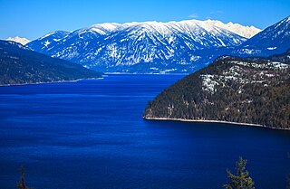
Nelson is a city located in the Selkirk Mountains on the West Arm of Kootenay Lake in the Southern Interior of British Columbia, Canada. Known as "The Queen City", and acknowledged for its impressive collection of restored heritage buildings from its glory days in a regional silver rush, Nelson is one of the three cities forming the commercial and population core of the West Kootenay region, the others being Castlegar and Trail. The city is the seat of the Regional District of Central Kootenay. It is represented in the provincial legislature by the riding of Nelson-Creston, and in the Parliament of Canada by the riding of Kootenay—Columbia.

The Kootenays or Kootenay is a region of southeastern British Columbia. It takes its name from the Kootenay River, which in turn was named for the Kutenai First Nations people.
Highway 6 is a two-lane highway passing between the Kootenay and Okanagan regions in the province of British Columbia, Canada. It is divided into two parts—the Nelson-Nelway Highway between the Canada–United States border and Nelson, and the Vernon-Slocan Highway between South Slocan and Vernon. Highway 6 is a north–south highway between Nelway and the Needles Ferry and an east–west highway between the Needles Ferry and Vernon; it has a total length of 407 km (253 mi). It first opened in 1941, and its very winding path through the western Kootenays has not changed since.

Castlegar is a community in the West Kootenay region of British Columbia, Canada. In the Selkirk Mountains, at the confluence of the Kootenay and Columbia Rivers, it is a regional trade and transportation centre, with a local economy based on forestry, mining and tourism.

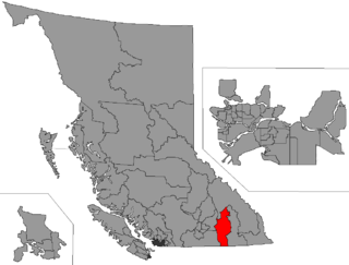
The Regional District of Central Kootenay (RDCK) is a regional district in the province of British Columbia, Canada. As of the 2016 census, the population was 59,517. The area is 22,130.72 square kilometres. The administrative centre is located in the city of Nelson. Other municipalities include the City of Castlegar, the Town of Creston, the Village of Salmo, the Village of Nakusp, the Village of Kaslo, the Village of New Denver, the Village of Silverton, the Village of Ymir and the Village of Slocan.
The Columbia and Kootenay Railway (C&KR) was a historic railway operated by the Canadian Pacific Railway (CPR) in the West Kootenay region of British Columbia. This 25-mile (40 km) route, beside the unnavigable Kootenay River, linked Nelson on the west arm of Kootenay Lake with Robson at the confluence of the Kootenay River and the Columbia River near Castlegar.
The Nakusp and Slocan Railway (N&S) is a historic Canadian railway that operated in the West Kootenay region of southeastern British Columbia. The N&S initially connected Nakusp and Three Forks but soon extended to Sandon.

British Columbia Southern Interior was a federal electoral district in the province of British Columbia, Canada, that had been represented in the House of Commons of Canada from 1997 to 2015.
Yale–Cariboo was a federal electoral district in British Columbia, Canada, that was represented in the House of Commons of Canada from 1896 to 1917.

The Columbia Mountains are a group of mountain ranges along the Upper Columbia River in British Columbia, Montana, Idaho and Washington. The mountain range covers 135,952 km². The range is bounded by the Rocky Mountain Trench on the east, and the Kootenai River on the south; their western boundary is the edge of the Interior Plateau. Seventy-five percent of the range is located in Canada and the remaining twenty-five percent in the United States; American geographic classifications place the Columbia Mountains as part of the Rocky Mountains complex, but this designation does not apply in Canada. Mount Sir Sandford is the highest mountain in the range, reaching 3,519 metres (11,545 ft).
Greenwood was the name of a provincial electoral district in the Canadian province of British Columbia. It was located in there Boundary Country west of Grand Forks around the city of Greenwood. It first appeared on the hustings in the large redistribution prior to the 1903 election. For the 1924 election it was merged with the Grand Forks riding to form Grand Forks-Greenwood.

Selkirk College is a public community college founded in 1966, with its main campus in Castlegar BC. The college has student housing at its Castlegar and Nelson campuses. Students frequently struggle to find accommodation. The college has seen shrinking enrolment for the past seven years, dropping from 1,987 FTE students in 2015/16 to 1,239 in 2022/23. International students currently account for 11% of total student headcount, a decrease of 3% over the past five years, the lowest rate for a public BC college. Indigenous students comprise 8% of total student numbers.
The Slocan Valley is a valley in the West Kootenay region of southeastern British Columbia.
British Columbia Highway 3, officially named the Crowsnest Highway, is an 841-kilometre (523 mi) highway that traverses southern British Columbia, Canada. It runs from the Trans-Canada Highway (Highway 1) at Hope to Crowsnest Pass at the Alberta border and forms the western portion of the interprovincial Crowsnest Highway that runs from Hope to Medicine Hat, Alberta. The highway is considered a Core Route of the National Highway System.
Kootenay West is a provincial electoral district in British Columbia, Canada, established by the Electoral Districts Act, 2008. It was first contested in the 2009 general election.
Rosebery is an unincorporated community about 6 kilometres (4 mi) north of New Denver in the West Kootenay region of southeastern British Columbia. The former steamboat landing and ferry terminal is at the mouth of Wilson Creek on the eastern shore of Slocan Lake. The locality, on BC Highway 6, is about 106 kilometres (66 mi) by road north of Castlegar and 144 kilometres (89 mi) by road and ferry south of Revelstoke.
Roy Edward Conroy was a Canadian politician who served as Member of the Legislative Assembly (MLA) for Rossland-Trail in the Canadian province of British Columbia from 1991 to 2001. He was a member of the British Columbia New Democratic Party.
Three Forks is a ghost town at the junction of Carpenter, Seaton, and Kane creeks in the West Kootenay region of southeastern British Columbia. This former mining community, on BC Highway 31A, is by road about 8 kilometres (5 mi) east of New Denver and 38 kilometres (24 mi) west of Kaslo.
West Kootenay Roller Derby (WKRD) is a roller derby league based in The Kootenays region of British Columbia in Canada. Co-founded in 2009 as the West Kootenay Women's Roller Derby League (WKWRDL) by Shelly "Hoar Frost" Grice-Gold, the league consists of five house teams, and an all-star travel team which competes against teams from other leagues for national standings.