
A ZIP Code is a postal code used by the United States Postal Service (USPS). Introduced in 1963, the basic format consisted of five digits. In 1983, an extended ZIP+4 code was introduced; it included the five digits of the ZIP Code, followed by a hyphen and four digits that designated a more specific location.

Day Township is a civil township of Montcalm County in the U.S. state of Michigan. As of the 2000 census, the township population was 1,282.
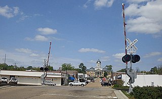
Mendenhall is a city in Simpson County, Mississippi, United States. The population was 2,504 at the 2010 census. It is the county seat of Simpson County. Mendenhall is part of the Jackson Metropolitan Statistical Area.
Westville is a borough in Gloucester County, New Jersey, United States. As of the 2010 United States Census, the borough's population was 4,288, reflecting a decline of 212 (-4.7%) from the 4,500 counted in the 2000 Census, which had in turn declined by 73 (-1.6%) from the 4,573 counted in the 1990 Census. The Borough of Westville is known as "The Gateway to South Jersey!"

Westville is a town in Franklin County, New York, United States. As of the 2010 census, the town had a population of 1,819. Westville is on the north border of the county, northwest of Malone.

Westville is an unincorporated community in northeastern Mad River Township, Champaign County, Ohio, United States. Although it is unincorporated, it has a post office, with the ZIP code of 43083. It lies at the intersection of U.S. Route 36 with State Route 560.

Wyckoff Heights is an area within the New York City boroughs of Brooklyn and Queens, straddling the border between Bushwick, Brooklyn, and southwest Ridgewood, Queens. Wyckoff Heights was urbanized starting in the late 19th century, and took its name from the Wyckoff family, who owned the land. The area was home first to many German immigrants, later followed by Italian and more recently Latino and Eastern-European residents.
Eldred is a rural hamlet located in the central part of the town of Highland, Sullivan County, New York, United States. The community is located along New York State Route 55, approximately 13.5 miles (21.7 km) southwest of Monticello. Eldred has a post office, which opened on October 5, 1831, with the current ZIP code as 12732. Other points of interest in the hamlet include the Highland Town Hall, Sunshine Hall Free Library, a firehouse, several churches and parks, and a Dollar General store. Public education in Eldred is serviced through the Eldred Central School District.
Byersville is an unincorporated community and census-designated place (CDP) in the town of West Sparta, Livingston County, New York, United States. As of the 2010 census, its population was 47. The ZIP Code is 14517.
Hankins is a hamlet in Sullivan County, New York, United States. The community is located along New York State Route 97 and the Delaware River 8.2 miles (13.2 km) west-northwest of Jeffersonville. Hankins has a post office with ZIP code 12741.
Kauneonga Lake is a hamlet in Sullivan County, New York, United States. The community is located along New York State Route 55 8 miles (13 km) west-northwest of Monticello. Kauneonga Lake has a post office with ZIP code 12749.

Lake Huntington is a hamlet in the Town of Cochecton in Sullivan County, New York, United States. The community is located along New York State Route 52 15.8 miles (25.4 km) west of Monticello. Lake Huntington has a post office with ZIP code 12752, which opened on February 2, 1893.
Mongaup Valley is a hamlet in Sullivan County, New York, United States. The community is located along New York State Route 17B 5 miles (8.0 km) west of Monticello. Mongaup Valley has a post office with ZIP code 12762, which opened on June 22, 1848.
Sparrow Bush is a hamlet in Orange County, New York, United States. The community is located along New York State Route 42 and New York State Route 97 2.3 miles (3.7 km) northwest of Port Jervis. Sparrow Bush has a post office with ZIP code 12780.
North Granville is a hamlet in Washington County, New York, United States. The community is located along New York State Route 22 5 miles (8.0 km) northwest of the village of Granville. North Granville has a post office with ZIP code 12854.
Stittville is a hamlet in the town of Marcy in Oneida County, New York, United States. The community is located along New York State Route 291, 9 miles (14 km) north-northwest of Utica. Stittville has a post office with ZIP code 13469.
Mount Vision is a hamlet in Otsego County, New York, United States. The community is located along New York State Route 205 8.7 miles (14.0 km) north of Oneonta. Mount Vision has a post office with ZIP code 13810. Mount Vision was formerly known as Jacksonville. A tuberculosis sanatorium was located here in the early 20th century.
Portlandville is a hamlet in Otsego County, New York, United States. The community is located along the Susquehanna River and New York State Route 28 7.3 miles (11.7 km) northeast of Oneonta. Portlandville has a post office with ZIP code 13834, which opened on April 9, 1828.
Wells Bridge is a hamlet in Otsego County, New York, United States. The community is located along the Susquehanna River and New York State Route 7 4.2 miles (6.8 km) west-southwest of Otego. Wells Bridge has a post office with ZIP code 13859.

Hartwick Seminary is a hamlet in Otsego County, New York, United States. The community is located along New York State Route 28, 5 miles (8.0 km) south of Cooperstown. Hartwick Seminary is served by ZIP code 13326.

