Woodend, Invercargill

Last updated

Woodend
Woodend, Invercargill
Coordinates: 46°28′30″S168°23′10″E / 46.475°S 168.386°E / -46.475; 168.386 Coordinates: 46°28′30″S168°23′10″E / 46.475°S 168.386°E / -46.475; 168.386
Country New Zealand
City Invercargill
Local authority Invercargill City Council
Area
[1]
  Land745 ha (1,841 acres)
Population
 (2018 Census) [2]
  Total174
Clifton, Invercargill Tisbury
(New River Estuary)
Pfeil oben.svg
Pfeil links.svgWoodendPfeil rechts.svg
Pfeil unten.svg
Motu Rimu
Awarua

Woodend is a rural suburb of the New Zealand city of Invercargill.

Contents

Demographics

Historical population for Woodend
YearPop.±% p.a.
2006171    
2013162−0.77%
2018174+1.44%
Source: [2]

Woodend covers 7.45 km2 (2.88 sq mi) [1] and is part of the Woodend-Greenhills statistical area. It had a population of 174 at the 2018 New Zealand census, an increase of 12 people (7.4%) since the 2013 census, and an increase of 3 people (1.8%) since the 2006 census. There were 69 households. There were 90 males and 81 females, giving a sex ratio of 1.11 males per female. The median age was 40.9 years (compared with 37.4 years nationally), with 39 people (22.4%) aged under 15 years, 21 (12.1%) aged 15 to 29, 87 (50.0%) aged 30 to 64, and 24 (13.8%) aged 65 or older.

Ethnicities were 93.1% European/Pākehā, 12.1% Māori, 1.7% Asian, and 1.7% other ethnicities (totals add to more than 100% since people could identify with multiple ethnicities).

Although some people objected to giving their religion, 60.3% had no religion, 29.3% were Christian and 1.7% had other religions.

Of those at least 15 years old, 15 (11.1%) people had a bachelor or higher degree, and 54 (40.0%) people had no formal qualifications. The median income was $30,300, compared with $31,800 nationally. The employment status of those at least 15 was that 66 (48.9%) people were employed full-time, and 27 (20.0%) were part-time. [2]

Woodend-Greenhills statistical area

Woodend-Greenhills also includes Tiwai Point and Omaui, and surrounds but does not include Bluff. It covers 173.61 km2 (67.03 sq mi) [1] and had an estimated population of 660 as of June 2022, [3] with a population density of 4 people per km2.

Historical population for Woodend-Greenhills
YearPop.±% p.a.
2006612    
2013603−0.21%
2018597−0.20%
Source: [4]

Woodend-Greenhills had a population of 597 at the 2018 New Zealand census, a decrease of 6 people (−1.0%) since the 2013 census, and a decrease of 15 people (−2.5%) since the 2006 census. There were 246 households. There were 306 males and 291 females, giving a sex ratio of 1.05 males per female. The median age was 43.5 years (compared with 37.4 years nationally), with 117 people (19.6%) aged under 15 years, 81 (13.6%) aged 15 to 29, 306 (51.3%) aged 30 to 64, and 96 (16.1%) aged 65 or older.

Ethnicities were 87.4% European/Pākehā, 15.6% Māori, 1.5% Pacific peoples, 6.0% Asian, and 2.5% other ethnicities (totals add to more than 100% since people could identify with multiple ethnicities).

The proportion of people born overseas was 13.1%, compared with 27.1% nationally.

Although some people objected to giving their religion, 52.8% had no religion, 33.2% were Christian, 0.5% were Hindu and 2.0% had other religions.

Of those at least 15 years old, 60 (12.5%) people had a bachelor or higher degree, and 147 (30.6%) people had no formal qualifications. The median income was $32,600, compared with $31,800 nationally. 51 people (10.6%) earned over $70,000 compared to 17.2% nationally. The employment status of those at least 15 was that 261 (54.4%) people were employed full-time, 81 (16.9%) were part-time, and 6 (1.2%) were unemployed. [4]

Related Research Articles

<span class="mw-page-title-main">Kingston, New Zealand</span> Rural settlement in Otago, New Zealand

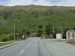
Kingston is a small town at the southernmost end of Lake Wakatipu, just north of the border of Otago and Southland, in New Zealand's South Island. It is 47 kilometres south of Queenstown by a road, "The Devil's Staircase", which winds between the lake to the west and The Remarkables mountains to the east. It is 70 kilometres north of Lumsden, and close to the headwaters of the Mataura River.

<span class="mw-page-title-main">Riwaka</span> Place in Tasman, New Zealand

Riwaka is a small settlement in the Tasman District of New Zealand's South Island. It lies beside Tasman Bay / Te Tai-o-Aorere, five kilometres north of Motueka, and close to the mouth of the Riuwaka River.

Pukeuri is a settlement to the north of Oamaru in the North Otago region of New Zealand's South Island. It is located near the coast in the Waitaki District that straddles the border of Otago and Canterbury.

<span class="mw-page-title-main">Waikuku</span> Town in Canterbury, New Zealand

Waikuku is a small town in the Canterbury region of New Zealand, which sits 28 km north of central Christchurch. Waikuku lies 11.8 km (7.3 mi) south of Leithfield on state highway 1 and 3 km (1.9 mi) north of Woodend. In 1901 there were 86 people resident in Waikuku according to that year's census. Waikuku settlement had a population of 156 people at the time of the 2018 Census. It is popular with both those that commute into work in Christchurch each day and with owners of holiday houses. Waikuku was home to rope and twine works. This business started off using flax from local swamps. It closed in 1987. The nearby sandy beach and pine forests are popular with surfers, swimmers, campers and horse-riders, and the large estuary of the Ashley River hosts many species of birds.

Wallacetown is a small town in Southland, in the South Island of New Zealand. Wallacetown is to the west of Invercargill, on high ground between the Makarewa and Ōreti rivers, near the Ōreti's estuary. Both rivers are popular for trout and whitebait fishing. It is considered to be a satellite town of Invercargill. It is served by State Highway 99, which skirts the town's northern edge.

Pamapuria is a locality in Northland, New Zealand. It lies on State Highway 1 about 10 km east of Kaitaia.

Omaui is a small coastal village in Southland region, New Zealand. It is located approximately 20 km southwest of Invercargill near a small estuary opposite Sandy Point between Invercargill and Bluff.

Maromaku is a locality in the Northland Region of the North Island of New Zealand. Kawakawa is north, and Towai is southeast. State Highway 1 runs past Maromaku to the north, and the North Auckland Line runs through it.

<span class="mw-page-title-main">The Pines Beach</span> Human settlement in Waimakariri District, Canterbury Region, New Zealand

The Pines Beach is a small town situated roughly 4 km east of Kaiapoi in the Canterbury region of the South Island of New Zealand. It is 1 km north of the mouth of the Waimakariri River. It takes its name from its close proximity to both a pine forest and the beach.

Stirling is a settlement in New Zealand. It is located in South Otago, approximately 5 km from Balclutha, and just north of the Matau Branch of the Clutha River.

<span class="mw-page-title-main">Chedworth Park</span> Suburb of Hamilton, New Zealand

Chedworth Park, also known simply as Chedworth, is a suburb in eastern Hamilton in New Zealand. It was defined as a suburb of Hamilton in 1974.

<span class="mw-page-title-main">Saint Andrews, Canterbury</span> Rural settlement in Canterbury, New Zealand

St Andrews is a small town in the south Canterbury region of New Zealand's South Island. It is located on State Highway 1 five kilometres south of Pareora and 17 kilometres south of Timaru. It was linked to Timaru by rail in 1876, and grew after the subdivision of the Pareora Run. It remains a rural service town.

<span class="mw-page-title-main">Ashley, New Zealand</span> Town in Canterbury, New Zealand

Ashley is a small town in North Canterbury, in the South Island of New Zealand. It used to have a railway station on the Main North Line that runs through the village.

Clifton is the southernmost suburb of New Zealand's southernmost city, Invercargill. It is located close to the shore of the New River estuary on State Highway 1, 5 kilometres (3.1 mi) southeast of the city centre and 4 kilometres (2.5 mi) northwest of Woodend. The Clifton Wastewater Treatment Plant is situated in this area.

<span class="mw-page-title-main">Wakefield, New Zealand</span> Locality in Tasman District, New Zealand

Wakefield is a settlement in the Tasman District of New Zealand's South Island, located about 25km south west of Nelson.

<span class="mw-page-title-main">Pōhara</span> Settlement in Tasman, New Zealand

Pōhara is a rural locality in the Tasman District of New Zealand's South Island. The locality is northeast of Tākaka and southwest of Tata Beach. To the north is Limestone Bay, part of Golden Bay / Mohua

<span class="mw-page-title-main">Waitakaruru</span> Locality in Waikato region, New Zealand

Waitakaruru is a rural community in the Hauraki District and Waikato region of New Zealand's North Island. It is situated at the mouth of Waitakaruru River

<span class="mw-page-title-main">Algies Bay</span> Suburb of Auckland Council in New Zealand

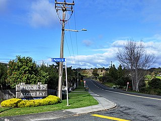
Algies Bay is a northern coastal suburb of Auckland, in New Zealand. It is on the Mahurangi Peninsula about 68 kilometres north of the city centre.

<span class="mw-page-title-main">Woodbourne, New Zealand</span> Place in Marlborough, New Zealand

Woodbourne is a rural settlement in Marlborough, New Zealand. It is located on State Highway 6, 8 kilometres (5 mi) west of Blenheim, and 4 km (2 mi) east of Renwick. Woodbourne Airport is the major airport for Marlborough, and RNZAF Base Woodbourne shares the airport's runways.

<span class="mw-page-title-main">Woodend Beach</span> Rural settlement in Canterbury, New Zealand

Woodend Beach is a small rural community in the Waimakariri District, New Zealand.

References

  1. 1 2 3 "ArcGIS Web Application". statsnz.maps.arcgis.com. Retrieved 22 February 2022.
  2. 1 2 3 "Statistical area 1 dataset for 2018 Census". Statistics New Zealand. March 2020. 7029800.
  3. "Population estimate tables - NZ.Stat". Statistics New Zealand . Retrieved 25 October 2022.
  4. 1 2 "Statistical area 1 dataset for 2018 Census". Statistics New Zealand. March 2020. Woodend-Greenhills (363100). 2018 Census place summary: Woodend-Greenhills