Šajkaška

Last updated • 4 min readFrom Wikipedia, The Free Encyclopedia
Šajkaška
Шајкашка
Sajkaska.png
Map of Šajkaška
CountryFlag of Serbia.svg  Serbia
Largest city Žabalj
Titel
Population
  Total67,355

Šajkaška (Шајкашка) is a historical region in northern Serbia. It is the southeastern part of Bačka, located in the Autonomous Province of Vojvodina. The territory of Šajkaška is divided among four municipalities: Titel, Žabalj, Novi Sad, and Srbobran. The historical center of Šajkaška is Titel.

Contents

Name

The name Šajkaška means "the land of Šajkaši". Šajkaši were a specific river marine infantry of the Habsburg army, which moved in narrow, long boats, known as "šajka". These military units had operated on the Danube, Tisa, Sava and Moriš rivers. In Hungarian, the region is known as Sajkásvidék and in German as Schajkaschka.

History

After 1400, the majority of the people in Šajkaška were Serbs who had settled the area before or after the Ottomans conquered the Balkan lands to the south . Moving further north, they had become established at Csepel Island, where they founded Srpski Kovin (Ráckeve). After 1526 and the Battle of Mohacs, they moved to the northern Danube and to the city of Komarno which, for a long time, was the administrative headquarters of the Šajkaš forces.

After the Treaty of Karlowitz in 1699, the region was part of the Habsburg monarchy. Most of Šajkaška was included into the Habsburg Military Frontier (its Danube and Tisa sections), while one part of the region was included into the Bodrog County. When these parts of the Military Frontier were abolished (in 1750), Šajkaška was included into the Theiss District, which was part of the Batsch-Bodrog County within the Habsburg Kingdom of Hungary. In 1763, Šajkaška was excluded from the Theiss District and was again placed under military administration. The Šajkaš Battalion, as part of the Military Frontier, was founded in this area. In the beginning of the Habsburg administration, the population of the region was composed entirely of Serbs, which were brave and skillful warriors. Serb Šajkaši have participated in many battles against the Ottoman Empire.

By 1739 and the Peace of Belgrade, the border between Austria and Turkey was moved to the Sava and Danube rivers, and at that time, the idea was proposed to move the Šajkaši down from the north. That was done from 1763 to 1764.

Location of the Sajkas Battalion, 18th-19th century Vojvodina18 19 cen.png
Location of the Šajkaš Battalion, 18th-19th century

From 1848 to 1849, the region was part of the autonomous Serbian Vojvodina, but was again included into the Military Frontier in 1849. In 1852, the Šajkaš battalion was transformed into the Titel infantry battalion. This military unit was abolished in 1873, and the region was again incorporated into the Bács-Bodrog County. Administratively, the territory of Šajkaška was organized into the municipality of Titel and the separate municipality of Žabalj was also later established. In 1910, ethnic Serbs formed the absolute majority in both municipalities. Besides Serbs who formed the majority in most settlements, the region was also populated by Hungarians who formed the majority in the village of Budisava and a sizable minority in a few other settlements, Germans who formed a sizable minority in several settlements and Rusyns who formed a sizable minority in Đurđevo.

In 1918, as part of the Banat, Bačka and Baranja region, Šajkaška became part of the Kingdom of Serbia and then part of the newly formed Kingdom of Serbs, Croats and Slovenes (later renamed to Yugoslavia). From 1918 to 1922 Šajkaška was part of the Novi Sad County, from 1922 to 1929 part of the Belgrade Oblast, and from 1929 to 1941 part of the Danube Banovina. From 1941 to 1944, the region was occupied by the Axis Powers, and was attached to the Bács-Bodrog County of Horthy's Hungary. In the 1942 raid, the Hungarian occupational authorities killed numerous ethnic Serbs, Jews and Romani in Šajkaška. In 1944, the Soviet Red Army and Yugoslav Partisans expelled the Axis forces from the region, and Šajkaška became part of the Autonomous Province of Vojvodina within the new Socialist Yugoslavia. From 1945, the AP of Vojvodina was part of the Socialist Republic of Serbia within Yugoslavia. Nowadays, Šajkaška is mainly an agricultural region, with a well-developed food industry.

Demographics

In 2002, the population of Šajkaška numbered 67,355 people, including:[ citation needed ]

Places of Šajkaška

The Titel municipality:

The Žabalj municipality:

The Novi Sad municipality:

The Srbobran municipality:

Note: Titel and Žabalj are towns and administrative centres of municipalities. Other places are villages.

Culture

There is a Serb Orthodox Kovilj monastery in the area. It is situated near the village of Kovilj. The monastery was reconstructed from 1705 to 1707. According to a legend, the monastery was founded by the first Serb archbishop Saint Sava in the 13th century.

See also

Related Research Articles

<span class="mw-page-title-main">Bačka</span> Geographical area in the Pannonian Plain

Bačka or Bácska is a geographical and historical area within the Pannonian Plain bordered by the river Danube to the west and south, and by the river Tisza to the east. It is divided between Serbia and Hungary. Most of the area is located within the Vojvodina region in Serbia and Novi Sad, the capital of Vojvodina, lies on the border between Bačka and Syrmia. The smaller northern part of the geographical area is located within Bács-Kiskun County in Hungary.

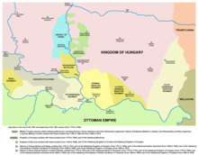
Šajkaši refers to the river flotilla troops guarding the Danube and Sava, and especially, the Port of Belgrade, against the Ottoman Empire from the 16th to the 19th century. During that period, the rivers were natural borders of the Kingdom of Hungary and Habsburg monarchy with the Ottoman Empire, part of the Military Frontier. The troops were composed of ethnic Serbs, who had special military status. Their name derives from the small wooden boat known as chaika, a type of galley.

<span class="mw-page-title-main">South Bačka District</span> District of Serbia

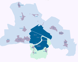
The South Bačka District is one of seven administrative districts of the autonomous province of Vojvodina, Serbia. Geographically it lies in the southern part of Bačka and northern part of Syrmia. According to the 2022 census results, it has a population of 607,178 inhabitants. The administrative center of the district is the city of Novi Sad, which is also the capital and the largest city of the Autonomous Province of Vojvodina.

<span class="mw-page-title-main">Bács-Bodrog County</span> County of the Kingdom of Hungary

Bács-Bodrog County was an administrative county of the Kingdom of Hungary from 1802 to 1920. Most of its territory is currently part of Serbia, while a smaller part belongs to Hungary. The capital of the county was Zombor.

Futog is a suburban settlement of the city of Novi Sad, Serbia, with a population of 18,642 according to the 2011 census in Serbia. It is situated in southern Bačka, 7 km away from Novi Sad.

<span class="mw-page-title-main">Titel</span> Town and municipality in Vojvodina, Serbia

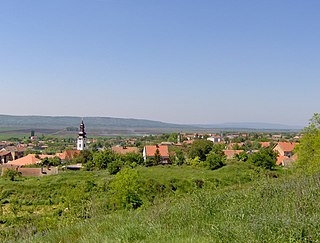
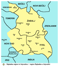
Titel is a town and municipality located in the South Bačka District of the province of Vojvodina, Serbia. The town of Titel has a population of 5,247, while the population of the municipality of Titel is 15,738. It is located in southeastern part of the geographical region of Bačka, known as Šajkaška.

<span class="mw-page-title-main">Temerin</span> Town and municipality in Vojvodina, Serbia

Temerin is a town and municipality located in the South Bačka District of the autonomous province of Vojvodina in Serbia. The town has a population of 19,613, while the municipality has a population of 28,287.

<span class="mw-page-title-main">Srbobran</span> Town and municipality in Vojvodina, Serbia

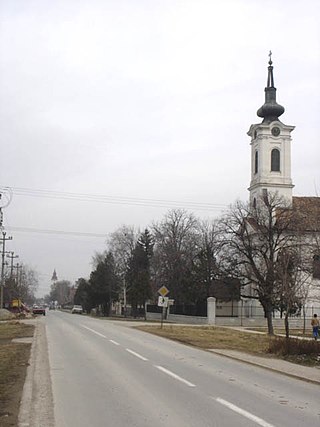
Srbobran is a town and municipality located in the South Bačka District of the autonomous province of Vojvodina, Serbia. The town is located on the north bank of the Danube-Tisa-Danube canal. The town has a population of 12,009, and the municipality of 16,317.

<span class="mw-page-title-main">Žabalj</span> Town and municipality in Vojvodina, Serbia

Žabalj is a town and municipality located in the South Bačka District of the autonomous province of Vojvodina, Serbia. In 2023 the town Žabalj has a population of 9,107 and the municipality Žabalj has a population of 25,777. It is located in southeastern part of Bačka, known as Šajkaška. All settlements in the municipality have an ethnic Serb majority.

<span class="mw-page-title-main">Potisje</span>

Potisje is the name of the Tisa river basin parts located in Serbia, in the autonomous province of Vojvodina. The river Tisa flows between the Banat and Bačka regions.

<span class="mw-page-title-main">Serbs in Vojvodina</span> Ethnic group in Vojvodina

The Serbs of Vojvodina are the largest ethnic group in this northern province of Serbia. For centuries, Vojvodina was ruled by several European powers, but Vojvodina Serbs never assimilated into cultures of those countries. Thus, they have consistently been a recognized indigenous ethnic minority with its own culture, language and religion. According to the 2022 census, there were 1,190,785 Serbs in Vojvodina or 68.43% of the population of the province.

<span class="mw-page-title-main">Kać</span> Selo in Vojvodina, Serbia

Kać is a suburban settlement of the city of Novi Sad, Serbia. The town had a population of 11,612 at the 2011 census.

<span class="mw-page-title-main">Kovilj</span> Suburban settlement in South Bačka, Vojvodina, Serbia

Kovilj is a suburban settlement of the city of Novi Sad, Serbia.

<span class="mw-page-title-main">Kisač</span> Suburban settlement in South Bačka, Vojvodina, Serbia

Kisač is a suburban settlement of the city of Novi Sad, Serbia. The settlement has a Slovak ethnic majority.

<span class="mw-page-title-main">Mošorin</span> Village in Vojvodina, Serbia

Mošorin is a village located in the Titel municipality, South Bačka District, Vojvodina, Serbia. The village has a Serb ethnic majority and its population numbering 2,569 people.

<span class="mw-page-title-main">Hungarians in Serbia</span> Ethnic group

Hungarians in Serbia are a recognized national minority in Serbia. According to the 2022 census, the population of ethnic Hungarians in Serbia is 184,442, constituting 2.8% of the total population, which makes them the second-largest ethnic group in the country behind Serbs and the largest minority group. The vast majority of them live in the northern autonomous province of Vojvodina, where they number 182,321 and make up 10.5% of the province's population. Almost 99% of all Hungarians in Serbia live in the province of Vojvodina. Most Hungarians in Serbia are Roman Catholics, while smaller numbers of them are Protestant. Their cultural center is located in Subotica.

<span class="mw-page-title-main">Čurug</span> Village in Vojvodina, Serbia

Čurug is a village located in the municipality of Žabalj, Serbia. It is situated in the Autonomous Province of Vojvodina. The village has a Serb ethnic majority and its population numbering 8,166 inhabitants. It is the biggest village in Serbia.

<span class="mw-page-title-main">Axis occupation of Vojvodina</span>

The military occupation of the Yugoslav region of Vojvodina from 1941 to 1944 was carried out by Nazi Germany and its client states / puppet regimes: Horthy's Hungary and Independent State of Croatia.

<span class="mw-page-title-main">City municipality of Novi Sad</span> City municipality in Vojvodina, Serbia

The City municipality of Novi Sad is one of two city municipalities which constitute the City of Novi Sad. According to the 2011 census results, the municipality has a population of 307,760 inhabitants, while the urban area has 250,439 inhabitants.

The history of the Serbian River Flotilla dates back to early 20th century, although its precursors originates as early as 16th century.

References