
Morrisonville is a small town in Christian County, Illinois, United States. The population was 1,056 at the 2010 census.

Charleston is a city in and the county seat of Coles County, Illinois, United States. The population was 21,838, as of the 2010 census. The city is home to Eastern Illinois University and has close ties with its neighbor, Mattoon. Both are principal cities of the Charleston–Mattoon Micropolitan Statistical Area.

Humboldt is a village in Coles County, Illinois, United States. As of the 2010 census, its population was 437. It is part of the Charleston–Mattoon Micropolitan Statistical Area.
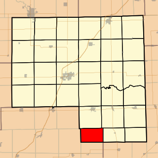
Tuscola is a city in Douglas County, Illinois, United States. The population was 4,480 at the 2010 census. It is the county seat of Douglas County.

Wheeler is a village in Jasper County, Illinois, United States. The population was 147 at the 2010 census.

Campus is a village in Round Grove Township, Livingston County, Illinois, United States. A small portion of the village lies in Broughton Township, Livingston County, Illinois to the south. The population was 145 at the 2000 census.

The Embarras River is a 195-mile-long (314 km) tributary of the Wabash River in southeastern Illinois in the United States. The waters of the Embarras reach the Gulf of Mexico via the Wabash, Ohio, and Mississippi Rivers. The river drains a watershed around 1,566,450 acres (6,339.2 km2) in an agricultural region. The name comes from French explorers, who used the term embarras for river obstacles, blockages, and difficulties relating to logjams and the like.

SS Samtampa was a 7,219 ton steamship wrecked on Sker Point, off Porthcawl and Kenfig, Wales, in the Bristol Channel on 23 April 1947. At the time of the shipwreck, the Samtampa was operated by the Houlder Line.

Area code 217 is the North American telephone area code for much of western, central, and parts of north southern Illinois. The 217 area code includes the Illinois capital, Springfield, plus Champaign, Urbana, Decatur, Danville, Effingham, Quincy, and Rantoul. 217 was one of the original area codes, which were created in 1947.

Granville was a town located in Milwaukee County, Wisconsin, United States. One portion was incorporated as the village of Brown Deer in 1955; the remainder consolidated with the City of Milwaukee in 1956, and became a neighborhood of Milwaukee.
Belle Prairie Township is located in Livingston County, Illinois in the United States. As of the 2010 census, its population was 135 and it contained 55 housing units.

Sunbury Township is located in Livingston County, Illinois. As of the 2010 census, its population was 229 and it contained 103 housing units. Contains 1,035 square miles of territory.
The village of Benjaminville, Illinois, was founded in McLean County, Illinois, United States during the 1850s by Quaker farmers, who, like many others who came to Illinois, were looking to take advantage of the rich prairie soil. The town's settlement centered on the Society of Friends and the meeting house that was first constructed there in 1859. The town was rendered a ghost town after 1870 when the expected Lake Erie Railroad did not come into town. Today the unincorporated community of Bentown, Illinois, exists near the site of the former town of Benjaminville.
Cardiff is a ghost town in Livingston County, Illinois, United States. Founded as a coal mining town in 1899, it boomed in its first few years. The closure of the mine in 1912 soon led to the community's demise. It is located in Round Grove Township, between the villages of Campus and Reddick.

Daniels is a ghost town straddling the Patapsco River east of Woodstock and north of Old Ellicott City in Baltimore County and Howard County, Maryland, United States. It is the location of the Daniels Mill, a site listed on the National Register of Historic Places. It is the home town of former Howard County Executive and State Senator James N. Robey. A postal office operated in the community from 1 March 1943 to 31 August 1971.
Streatorland is an informal name given to the geographic area in North Central Illinois that is centered geographically, politically, culturally, and economically, around the city of Streator. It consists of areas in southern LaSalle County and northwestern Livingston. It can be more broadly defined as the area east of Interstate 39, west of Interstate 55, and south of the Illinois River. Depending on the source, the panhandle of LaSalle County can be considered a part of Streatorland. There are several small towns that lie in the Streatorland area and filter into the Streator school district, though there are other schools in the area.
Fort Daniel Conservation Area is a 200-acre (0.8 km²) park located 4 miles (6.5 km) east of Mount Zion, Illinois. The land preserve protects the site of a ghost town, Whistleville. Today, the site centers on hiking and picknicking in the Big Creek watershed southeast of Decatur.
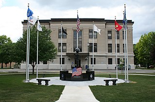
The Douglas County Courthouse is a government building in Tuscola, the county seat of Douglas County, Illinois, United States. Completed in 1913, it is the third courthouse in the history of Douglas County.

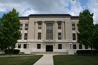
The Macon County Courthouse is a government building in Decatur, the county seat of Macon County, Illinois, United States. Completed in 1940, it is the fourth courthouse in the county's history.


