1872 Lone Pine earthquake

Last updated
1872 Lone Pine earthquake
Lone Pine fault scarp-1200px.jpg
Lone Pine fault scarp
Relief map of California.png
Green pog.svg
San Diego
Green pog.svg
Sacramento
Green pog.svg
Lone Pine
Bullseye1.png
Local dateMarch 26, 1872 (1872-03-26)
Local time02:30 [1]
Magnitude7.4–7.9 Mw [2]
Epicenter 36°42′N118°06′W / 36.7°N 118.1°W / 36.7; -118.1 Coordinates: 36°42′N118°06′W / 36.7°N 118.1°W / 36.7; -118.1 [1]
Type Oblique-slip [2]
Areas affected Eastern California
United States
Total damage$250,000 / limited [3]
Max. intensity X (Extreme) [1]
Casualties27 killed [1] [4]
56 injured [3]
Official nameGrave of 1872 Earthquake Victims [5]
Reference no.507

The 1872 Lone Pine earthquake struck on March 26 at 02:30 local time with an estimated moment magnitude of 7.4 to 7.9 and a maximum Mercalli Intensity of X (Extreme). Its epicenter was near Lone Pine, California, in Owens Valley. It was one of the largest earthquakes to hit California in recorded history and was similar in size to the 1906 San Francisco earthquake. Twenty-seven people were killed and fifty-six were injured.

The moment magnitude scale is a measure of an earthquake's magnitude based on its seismic moment, expressed in terms of the familiar magnitudes of the original "Richter" magnitude scale.

The epicenter, epicentre or epicentrum in seismology is the point on the Earth's surface directly above a hypocenter or focus, the point where an earthquake or an underground explosion originates.

Lone Pine, California Census designated place in California, United States

Lone Pine is a census designated place (CDP) in Inyo County, California, United States. Lone Pine is located 16 miles (26 km) south-southeast of Independence, at an elevation of 3,727 feet. The population was 2,035 at the 2010 census, up from 1,655 at the 2000 census. The town is located in the Owens Valley, near the Alabama Hills. From possible choices of urban, rural, and frontier, the Census Bureau identifies this area as "frontier". The local hospital, Southern Inyo Hospital, offers standby emergency services. The town is named after a solitary pine tree that once existed at the mouth of Lone Pine Canyon. On March 26, 1872, the very large Lone Pine earthquake destroyed most of the town and killed 27 of its 250 to 300 residents.

Contents

Tectonic setting

The earthquake resulted from sudden vertical movement of 15–20 feet (4.5–6m) and right-lateral movement of 35–40 feet (10.6–12m) on the Lone Pine Fault and part of the Owens Valley Fault. These faults are part of a twin system of normal faults that run along the base of two parallel mountain ranges; the Sierra Nevada on the west and Inyo Mountains on the east of the Owens Valley. It created fault scarps from north of Big Pine, 55 mi (89 km) north of Lone Pine, to Haiwee Reservoir (30 mi (48 km)) south of Lone Pine.

Sierra Nevada (U.S.) mountain range

The Sierra Nevada is a mountain range in the Western United States, between the Central Valley of California and the Great Basin. The vast majority of the range lies in the state of California, although the Carson Range spur lies primarily in Nevada. The Sierra Nevada is part of the American Cordillera, a chain of mountain ranges that consists of an almost continuous sequence of such ranges that form the western "backbone" of North America, Central America, South America and Antarctica.

Inyo Mountains mountain range in eastern California, United States

The Inyo Mountains are a short mountain range east of the Sierra Nevada mountains in eastern California in the United States. The range separates the Owens Valley to the west from Saline Valley to the east, extending for approximately 70 mi (130 km) SSE from the southern end of the White Mountains, from which they are separated by Westgard Pass, to east of Owens Lake.

Fault scarp A small step or offset on the ground surface where one side of a fault has moved vertically with respect to the other

A fault scarp is a small step or offset on the ground surface where one side of a fault has moved vertically with respect to the other. It is the topographic expression of faulting attributed to the displacement of the land surface by movement along faults. They are exhibited either by differential movement and subsequent erosion along an old inactive geologic fault, or by a movement on a recent active fault.

Earthquake

Scarp boulder that has been studied Pyramid stone on Lone Pine fault scarp-750px.jpg
Scarp boulder that has been studied

The earthquake occurred on a Tuesday morning and leveled almost all the buildings in Lone Pine and nearby settlements. [4] Of the estimated 250–300 inhabitants of Lone Pine, 27 are known to have perished and 52 of the 59 houses were destroyed. One report states that the main buildings were thrown down in almost every town in Inyo County. About 130 kilometers (81 mi) south of Lone Pine, at Indian Wells, Kern County, California, adobe houses sustained cracks. Property loss has been estimated at $250,000 (equivalent to $5,228,472in 2018). As in many earthquakes, adobe, stone and masonry structures fared worse than wooden ones which prompted the closing of nearby Camp Independence which was an adobe structure destroyed in the quake.

Inyo County, California County in California, United States

Inyo County is a county in the U.S. state of California. As of the 2010 census, the population was 18,546. The county seat is Independence.

Indian Wells, Kern County, California Unincorporated community in California, United States

Indian Wells is an unincorporated community in Kern County, California.

Adobe Building material made from earth and organic materials

Adobe is a building material made from earth and organic materials. Adobe is Spanish for mudbrick, but in some English-speaking regions of Spanish heritage, the term is used to refer to any kind of earth construction. Most adobe buildings are similar in appearance to cob and rammed earth buildings. Adobe is among the earliest building materials, and is used throughout the world.

The quake was felt strongly as far away as Sacramento, where citizens were startled out of bed and into the streets. Giant rockslides in what is now Yosemite National Park woke naturalist John Muir, then living in Yosemite Valley, who reportedly ran out of his cabin shouting, "A noble earthquake!" and promptly made a moonlit survey of the fresh talus piles. This earthquake stopped clocks and awakened people in San Diego, California, to the south, Red Bluff, California, to the north, and Elko, Nevada, to the east. The shock was felt over most of California and much of Nevada. Thousands of aftershocks occurred, some severe.

Sacramento, California State capital and city of California, United States

Sacramento is the capital city of the U.S. state of California and the seat of Sacramento County. Located at the confluence of the Sacramento River and the American River in Northern California's Sacramento Valley, Sacramento's estimated 2018 population of 501,334 makes it the sixth-largest city in California and the ninth largest capital in the United States. Sacramento is the seat of the California Legislature and the Governor of California, making it the state's political center and a hub for lobbying and think tanks. Sacramento is also the cultural and economic core of the Sacramento metropolitan area, which had a 2010 population of 2,414,783, making it the fifth largest in California.

Rockslide type of landslide caused by rock failure

A rockslide is a type of landslide caused by rock failure in which part of the bedding plane of failure passes through compacted rock and material collapses en masse and not in individual blocks. While a landslide occurs when loose dirt or sediment falls down a slope, a rockslide occurs only when solid rocks are transported down slope. The rocks tumble downhill, loosening other rocks on their way and smashing everything in their path. Fast-flowing rock slides or debris slides behave similarly to snow avalanches, and are often referred to as rock avalanches or debris avalanches.

Yosemite National Park National park in California, United States

Yosemite National Park is an American national park located in the western Sierra Nevada of Central California, bounded on the southeast by Sierra National Forest and on the northwest by Stanislaus National Forest. The park is managed by the National Park Service and covers an area of 748,436 acres and sits in four counties: centered in Tuolumne and Mariposa, extending north and east to Mono and south to Madera County. Designated a World Heritage site in 1984, Yosemite is internationally recognized for its granite cliffs, waterfalls, clear streams, giant sequoia groves, lakes, mountains, meadows, glaciers, and biological diversity. Almost 95% of the park is designated wilderness.

Aftermath

Original plaque and memorial for the 1872 earthquake. 1872-Earthquake-Grave.jpeg
Original plaque and memorial for the 1872 earthquake.
More recent memorial of the earthquake, installed March 26, 1988. 1872-Earthquake-Memorial.jpeg
More recent memorial of the earthquake, installed March 26, 1988.

Researchers later estimated that similar earthquakes occur on the Lone Pine fault every 3,000–4,000 years. However, the Lone Pine fault is only one of many faults on two parallel systems.

This earthquake also formed a small graben that later was filled by water, creating 86-acre (350,000 m2) Diaz Lake. [6]

Graben Depressed block of planetary crust bordered by parallel faults

In geology, a graben is a depressed block of the crust of a planet bordered by parallel faults.

Diaz Lake lake of the United States of America

Diaz Lake, elevation 3,674 feet (1,120 m), is located in the Owens Valley, just south of Lone Pine, California, United States. It covers 80 acres (32 ha).

The common grave of the earthquake's victims is now registered as California Historical Landmark #507. [5]

California Historical Landmark Buildings, structures, sites, or places in California determined to have historical significance

A California Historical Landmark (CHL) is a building, structure, site, or place in California that has been determined to have statewide historical landmark significance.

See also

Related Research Articles

Owens Valley valley in California, USA

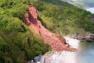
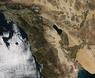
Owens Valley is the now-arid valley of the Owens River in eastern California in the United States, to the east of the Sierra Nevada and west of the White Mountains and Inyo Mountains on the west edge of the Great Basin. The mountain peaks on either side reach above 14,000 feet (4,300 m) in elevation, while the floor of the Owens Valley is about 4,000 feet (1,200 m), making the valley one of the deepest in the United States. The Sierra Nevada casts the valley in a rain shadow, which makes Owens Valley "the Land of Little Rain." The bed of Owens Lake, now a predominantly dry endorheic alkali flat, sits on the southern end of the valley.

1857 Fort Tejon earthquake 1857 earthquake in California, United States

The 1857 Fort Tejon earthquake occurred at about 8:20 a.m. on January 9 in central and Southern California. One of the largest recorded earthquakes in the United States, with an estimated moment magnitude of 7.9, it ruptured the southern part of the San Andreas Fault for a length of about 225 miles, between Parkfield and Wrightwood.

1999 Hector Mine earthquake

The 1999 Hector Mine earthquake occurred on October 16 at 02:46:50 PDT with a moment magnitude of 7.1 and a maximum Mercalli intensity of VII. The strike-slip earthquake occurred in a remote part of the Mojave Desert, 47 miles (76 km) east-southeast of Barstow, California, inside the Twentynine Palms Marine Corps Base. Its name comes from a nearby quarry named Hector Mine, which is located 22 kilometers (14 mi) northwest of the epicenter.

1992 Landers earthquake

The 1992 Landers earthquake occurred on June 28 with an epicenter near the town of Landers, California. The shock had a moment magnitude of 7.3 and a maximum Mercalli intensity of IX (Violent).

The Reno earthquakes of 2008, also known as the "Mogul-Somersett earthquake sequence", occurred in or near the western Reno, Nevada, suburbs of Mogul and Somersett. The earthquake swarm began in February 2008, but the first significant quake of the series occurred on April 15, 2008, registering a 3.6 magnitude. On April 24, 2008, two quakes in the same area registered 4.1 and 4.2. On April 25, 2008, the quake of largest magnitude occurred, registering 4.7 on the Richter scale and causing damage in the immediate area around the epicenter, including destroying 200 feet of a wooden flume supplying water from the Highland Ditch, also known as the Highland Ditch flume. The flume carried up to 50 million US gallons (190,000 m3) a day from the Highland Ditch to Reno's Chalk Bluff Water Treatment Facility and another 5 million US gallons (19,000 m3) to area irrigation users.

1999 Chamoli earthquake 1999 earthquake in India

The 1999 Chamoli earthquake occurred on 29 March in the Chamoli district in the Indian state of Uttar Pradesh. The earthquake was the strongest to hit the foothills of the Himalayas in more than ninety years. Approximately 103 people died in the earthquake.

San Jacinto Fault Zone

The San Jacinto Fault Zone (SJFZ) is a major strike-slip fault zone that runs through San Bernardino, Riverside, San Diego, and Imperial Counties in Southern California. The SJFZ is a component of the larger San Andreas transform system and is considered to be the most seismically active fault zone in the area. Together they relieve the majority of the stress between the Pacific and North American tectonic plates.

2007 Alum Rock earthquake

The 2007 Alum Rock earthquake occurred on October 30 at 8:04 p.m. Pacific Daylight Time in Alum Rock Park in San Jose, California. It measured 5.6 on the moment magnitude scale and had a maximum Mercalli intensity of VI (Strong). The event was then the largest in the San Francisco Bay Area since the 1989 Loma Prieta earthquake, which measured 6.9 on the moment magnitude scale, but was later surpassed by the 2014 South Napa earthquake. Ground shaking from the Alum Rock quake reached San Francisco and Oakland and other points further north. Sixty thousand felt reports existed far beyond Santa Rosa, as far north as Eugene, Oregon.

1868 Hayward earthquake

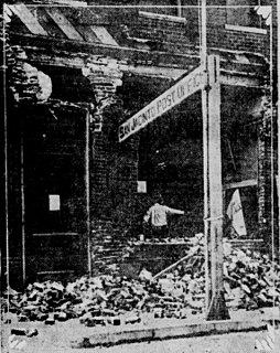
The 1868 Hayward earthquake occurred in the San Francisco Bay Area, California, United States on October 21. With an estimated moment magnitude of 6.3–6.7 and a maximum Mercalli intensity of IX (Violent), it was the most recent large earthquake to occur on the Hayward Fault Zone. It caused significant damage and a number of deaths throughout the region, and was known as the "Great San Francisco earthquake" prior to the 1906 San Francisco earthquake and fire.

1915 Pleasant Valley earthquake earthquake struck to the south of Winnemucca, Nevada on October 3, 1915

The 1915 Pleasant Valley earthquake occurred at 22:53:21 on October 2 in north-central Nevada. With a moment magnitude of 6.8 and a maximum Mercalli intensity of X (Extreme), it was the strongest earthquake ever recorded in the state.

2010 Eureka earthquake

The 2010 Eureka earthquake occurred on January 9 at 4:27:38 pm PST offshore of Humboldt County, California, United States. The magnitude was measured 6.5 on the Mw scale, and its epicenter was located offshore in the Pacific Ocean 33 miles (53 km) west of the nearest major city, Eureka. Additionally, there was a separate earthquake further offshore of Eureka on February 4 with a slightly lower magnitude of 5.9. It was also the most significant earthquake in the Eureka area in terms of magnitude since the 1992 Cape Mendocino earthquakes. It was felt from Santa Cruz County, California in the south, to Eugene, Oregon in the north and to the east as far as Reno, Nevada.

1986 Chalfant Valley earthquake

The 1986 Chalfant Valley earthquake struck southern Mono County near Bishop and Chalfant, California at 07:42:28 Pacific Daylight Time on July 21. With a moment magnitude of 6.2 and a maximum Mercalli intensity of VI (Strong), the shock injured two people and caused property damage estimated at $2.7 million in the affected areas. There was a significant foreshock and aftershock sequence that included a few moderate events, and was the last in a series of three earthquakes that affected southern California and the northern Owens Valley in July 1986.

Brawley Seismic Zone

The Brawley Seismic Zone (BSZ), also known as the Brawley fault zone, is a predominantly extensional tectonic zone that connects the southern terminus of the San Andreas Fault with the Imperial Fault in Southern California. The BSZ is named for the nearby town of Brawley in Imperial County, California, and the seismicity there is characterized by earthquake swarms.

2011 Dalbandin earthquake January 2011 earthquake in Pakistan

The 2011 Dalbandin earthquake occurred on January 19 at 01:23 AM local time with a moment magnitude of Mw 7.2 and a maximum Mercalli intensity of VI (Strong). The shock occurred in a sparsely populated area of Balochistan, caused moderate damage, three deaths and some injuries.

1892 Laguna Salada earthquake

The 1892 Laguna Salada earthquake occurred at 23:20 Pacific Standard Time on February 23. It had an estimated moment magnitude of 7.1–7.2 and a maximum perceived intensity of VIII (Severe). The shock was centered near the Mexico–United States border and takes its name from a large dry lake bed in Baja California, Mexico. There were no reported casualties, but the event affected the then largely-uninhabited areas of northern Mexico and Southern California.

1892 Vacaville–Winters earthquakes

The 1892 Vacaville–Winters earthquakes occurred in northern California as a large doublet on April 19 and April 21. Measured on a seismic scale that is based on an isoseismal map or the event's felt area, the 6.4 Mla and 6.2 Mla  events were assigned a maximum Mercalli intensity of IX (Violent), and affected the North Bay and Central Valley areas. While the total damage was estimated at between $225,000–250,000, one person was killed, but there are no reports on how many people may have been injured. No surface faulting was observed as a result of either strong shocks.

1918 San Jacinto earthquake earthquake which occurred in extreme eastern San Diego County in Southern California on April 21, 1918, at 14:32:29 local time

The 1918 San Jacinto earthquake occurred in extreme eastern San Diego County in Southern California on April 21 at 14:32:29 local time. The shock had a moment magnitude of 6.7 and a maximum Mercalli intensity of IX (Violent). Several injuries and one death occurred with total losses estimated to be $200,000.

1838 San Andreas earthquake

The 1838 San Andreas earthquake is believed to be a rupture along the northern part of the San Andreas Fault in June 1838. It affected approximately 100 km of the fault, from the San Francisco Peninsula to the Santa Cruz Mountains. It was a strong earthquake, with an estimated moment magnitude of 6.8 to 7.2, making it one of the largest known earthquakes in California. The region was lightly populated at the time, although structural damage was reported in San Francisco, Oakland, and Monterey. It is unknown whether there were fatalities. Based on geological sampling, the fault created approximately 1.5 meters of slip.

Olancha Earthquake Sequence (2009)

The Olancha Earthquake Sequence (2009) was a consecutive series of three earthquakes, with high magnitudes of 5.2, 5.0 and 4.9 respectively, with a number of small shocks between each, to accompany the main "triple shock".

2019 Ridgecrest earthquakes July 4–5, 2019, earthquakes in California

The 2019 Ridgecrest earthquakes of July 4 and 5 occurred north and northeast of the town of Ridgecrest, California and west of Searles Valley, California. They included three main shocks of Mw magnitudes 6.4, 5.4, and 7.1, and many perceptible aftershocks, mainly within the area of the Naval Air Weapons Station China Lake. The first main shock occurred on July 4 at 10:33 a.m. PDT, approximately 18 km (11.2 mi) ENE of Ridgecrest, and 13 km (8.1 mi) WSW of Trona, on a previously unnoticed NE-SW trending fault where it intersects the NW-SE trending Little Lake Fault Zone. This quake was preceded by several smaller earthquakes, and was followed by more than 1,400 detected aftershocks. The M 5.4 and M 7.1 quakes struck on July 5 at 4:08 a.m. and 8:19 p.m. PDT approximately 10 km (6 miles) to the northwest. The latter, now considered the mainshock, was the most powerful earthquake to occur in the state in 20 years. Subsequent aftershocks extended approximately 50 km (~30 miles) along the Little Lake Fault Zone.

References

  1. 1 2 3 4 Stover, C. W.; Coffman, J. L. (1993), Seismicity of the United States, 1568–1989 (Revised), U.S. Geological Survey Professional Paper 1527, United States Government Printing Office, pp. 73, 105
  2. 1 2 Hough, S. E.; Hutton, K. (2008), "Revisiting the 1872 Owens Valley, California, Earthquake", Bulletin of the Seismological Society of America, 98 (2): 931, 932, Bibcode:2008BuSSA..98..931H, doi:10.1785/0120070186
  3. 1 2 National Geophysical Data Center / World Data Service (NGDC/WDS) (1972), Significant Earthquake Database (Data Set), National Geophysical Data Center, NOAA, doi:10.7289/V5TD9V7K
  4. 1 2 "State's Biggest Quake Struck 100 Years Ago". Los Angeles Times . Mar 26, 1972.
  5. 1 2 "Grave of 1872 Earthquake Victims". Office of Historic Preservation, California State Parks. Retrieved 2012-10-07.
  6. Hall, Jr., C. A. (2007). Introduction to the geology of southern California and its native plants. University of California Press. p. 231. ISBN   978-0-520-24932-5.
Bibliography