
Ayrshire is a historic county and registration county, in south-west Scotland, located on the shores of the Firth of Clyde. The lieutenancy area of Ayrshire and Arran covers the entirety of the historic county as well as the island of Arran, formerly part of the historic county of Buteshire. Its principal towns include Ayr, Kilmarnock and Irvine and it borders the counties of Renfrewshire and Lanarkshire to the north-east, Dumfriesshire to the south-east, and Kirkcudbrightshire and Wigtownshire to the south. Like many other counties of Scotland, it currently has no administrative function, instead being sub-divided into the council areas of East Ayrshire, North Ayrshire and South Ayrshire. It has a population of approximately 366,800.

Aberdeen City Council is the local authority for Aberdeen City, one of the 32 council areas of Scotland. In its modern form it was created in 1996. Aberdeen was formerly governed by a corporation from when it was made a burgh in the twelfth century until 1975. Between 1975 and 1996 the city was governed by City of Aberdeen District Council, a lower-tier authority within the Grampian region.

South Ayrshire is one of thirty-two council areas of Scotland, covering the southern part of Ayrshire. It borders onto Dumfries and Galloway, East Ayrshire and North Ayrshire. South Ayrshire had an estimated population in 2021 of 112,450, making it the 19th–largest subdivision in Scotland by population. With an area of 472 sq mi, South Ayrshire ranks as the 15th largest subdivision in Scotland.

East Renfrewshire is one of 32 council areas of Scotland. It was formed in 1996, as a successor to the Eastwood district of the Strathclyde region. The northeastern part of the council area is close to Glasgow and many of the council area's northern settlements fall into the Greater Glasgow urban area.

Renfrewshire is one of the 32 council areas of Scotland.

Glasgow City Council is the local government authority for Glasgow City council area, Scotland. In its modern form it was created in 1996. Glasgow was formerly governed by a corporation, also known as the town council, from the granting of its first burgh charter in the 1170s until 1975. From 1975 until 1996 the city was governed by City of Glasgow District Council, a lower-tier authority within the Strathclyde region.
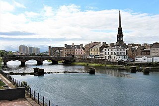
Ayr, is a town situated on the southwest coast of Scotland. A former royal burgh, today it is the administrative centre of South Ayrshire Council, and the historic county town of Ayrshire. With a population of 46,982, Ayr is the 15th largest settlement in Scotland and second largest town in Ayrshire by population. The town is contiguous with the smaller town of Prestwick to the north. Ayr submitted unsuccessful bids for city status in 2000 and 2002, and as part of the wider South Ayrshire area in 2022.

Lanark is a town in South Lanarkshire, Scotland, located 20 kilometres to the south-east of Hamilton. The town lies on the River Clyde, at its confluence with Mouse Water. In 2016, the town had a population of 9,050.
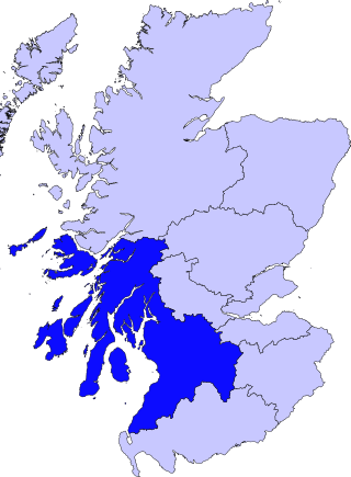
Strathclyde was one of nine former local government regions of Scotland created in 1975 by the Local Government (Scotland) Act 1973 and abolished in 1996 by the Local Government etc. (Scotland) Act 1994. The Strathclyde region had 19 districts. The region was named after the early medieval Kingdom of Strathclyde centred on Govan, but covered a broader geographic area than its namesake.
The Stirling council area is one of the 32 council areas of Scotland, and has an estimated population of 92,530 (2022). It was created in 1975 as a lower-tier district within the Central region. The district covered parts of the historic counties of Stirlingshire and Perthshire, which were abolished for local government purposes. In 1996 the Central region was abolished and Stirling Council took over all local government functions within the area.

Cunninghame is a former comital district of Scotland and also a district of the Strathclyde Region from 1975 to 1996.

East Dunbartonshire was a county constituency of the House of Commons of the Parliament of the United Kingdom (Westminster). It elected one Member of Parliament (MP) by the first past the post system of election. The seat is possibly best known for formerly being the constituency of Jo Swinson, the former Leader of the Liberal Democrats who was defeated at the 2019 general election.

Central Ayrshire is a constituency of the British House of Commons, located in the south-west of Scotland within the North Ayrshire and South Ayrshire council areas. It elects one Member of Parliament (MP) at least once every five years using the first-past-the-post system of voting.
Ayr is a burgh constituency of the Scottish Parliament (Holyrood) covering the town of Ayr in the council area of South Ayrshire. It elects one Member of the Scottish Parliament (MSP) via the plurality electoral system. It is also one of nine constituencies in the South Scotland electoral region which elects seven additional members to the Scottish Parliament via a proportional electoral system known as the Additional Members System which allows for greater accuracy in representation for the region as a whole.
Kilmarnock was a county constituency of the House of Commons of the Parliament of the United Kingdom from 1918 to 1983. It elected one Member of Parliament (MP) by the first past the post system of election.

The City of Glasgow was a local government district in the Strathclyde region of Scotland from 1975 to 1996.
The politics of Glasgow, Scotland's largest city by population, are expressed in the deliberations and decisions of Glasgow City Council, in elections to the council, the Scottish Parliament and the UK Parliament.
Scottish local elections were held in 1967 to elect members to the various Corporations, Burghs, and County Boards of Scotland.
Arthur Walker Brady was a Scottish politician.
Elections to Cumnock and Doon Valley District Council were held on 7 May 1974, on the same day as the other Scottish local government elections. This was the first election to the district council following the implementation of the Local Government (Scotland) Act 1973.
