
Alameda is a city in Alameda County, California, United States, located in the East Bay region of the Bay Area. The city is built on an informal archipelago in San Francisco Bay, consisting of Alameda Island, Bay Farm Island and Coast Guard Island, along with other smaller islands. As of the 2020 census, the city's population was 78,280.

Oakland is a city in the East Bay region of the San Francisco Bay Area in the U.S. state of California. It is the county seat and most populous city in Alameda County, with a population of 440,646 in 2020. A major West Coast port, Oakland is the most populous city in the East Bay, the third most populous city in the Bay Area, and the eighth most populous city in California. It serves as the Bay Area's trade center: the Port of Oakland is the busiest port in Northern California, and the fifth- or sixth-busiest in the United States. A charter city, Oakland was incorporated on May 4, 1852, in the wake of the state's increasing population due to the California gold rush.

Alameda County is a county located in the U.S. state of California. As of the 2020 census, the population was 1,682,353, making it the 7th-most populous county in the state and 21st most populous nationally. The county seat is Oakland. Alameda County is in the San Francisco Bay Area, occupying much of the East Bay region.

Oakland International Airport, officially Metropolitan Oakland International Airport, is an international airport in Oakland, California, United States. The airport is located 7 miles (11 km) south of Downtown Oakland and 12 miles (19 km) east of San Francisco, serving the East Bay of the San Francisco Bay Area. The airport is owned by the Port of Oakland and has domestic passenger flights to cities throughout the United States and international flights to Mexico, El Salvador, and Portugal, in addition to cargo flights to China and Japan. The airport covers 2,600 acres (1,100 ha) of land. The airport is an operating base for Southwest Airlines, which operates point-to-point routes with bases instead of a traditional network with hubs.

Lake Merritt is a lake located in a large tidal lagoon basin in the center of Oakland, California, just east of Downtown. It is named after Samuel Merritt, Oakland's mayor in 1867–1869, who had the lagoon dammed turning the varying tidal lagoon into a stable salt-water lake. It is surrounded by parkland and city neighborhoods. Historically significant as the first official wildlife refuge in the United States, designated in 1870, the lake has been listed as a National Historic Landmark since 1963. The circumference of the lake is 3.4 miles (5.5 km), with an area of 155 acres (63 ha).
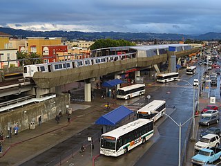
Fruitvale station is a Bay Area Rapid Transit (BART) station located in the Fruitvale District of Oakland, California. The elevated station has two side platforms. The station is served by the Orange, Green, and Blue lines.
Fruitvale is a neighborhood in Oakland, California, United States. It is located approximately 4 miles (6.44 km) southeast of Downtown, and is home to the city's largest Hispanic population, with Hispanics constituting 53.8% of Fruitvale's population. Fruitvale's ZIP code is 94601. It lies at an elevation of 49 feet.

Howard Terminal Ballpark was a proposed baseball stadium to be built in the Jack London Square neighborhood of Oakland, California. If approved and constructed, it would have served as the new home stadium of the Oakland Athletics of Major League Baseball (MLB), replacing the Oakland Coliseum. The 34,000-seat stadium was the last of several proposals to keep the Athletics in Oakland. The site is currently a parcel of land owned by the Port of Oakland. After securing the site, the Athletics planned to have the stadium built and operational after the team's lease expired at the Oakland Coliseum in 2024.
Rancho San Antonio, also known as the Peralta Grant, was a 44,800-acre (181 km2) land grant by Governor Pablo Vicente de Solá, the last Spanish governor of California, to Don Luís María Peralta, a sergeant in the Spanish Army and later, commissioner of the Pueblo of San José, in recognition of his forty years of service. The grant, issued on August 3, 1820, embraced the sites of the cities of San Leandro, Oakland, Alameda, Emeryville, Piedmont, Berkeley, and Albany.

The East Bay Electric Lines were a unit of the Southern Pacific Railroad that operated electric interurban-type trains in the East Bay region of the San Francisco Bay Area. Beginning in 1862, the SP and its predecessors operated local steam-drawn ferry-train passenger service in the East Bay on an expanding system of lines, but in 1902 the Key System started a competing system of electric lines and ferries. The SP then drew up plans to expand and electrify its system of lines and this new service began in 1911. The trains served the cities of Berkeley, Albany, Emeryville, Oakland, Alameda, and San Leandro transporting commuters to and from the large Oakland Pier and SP Alameda Pier. A fleet of ferry boats ran between these piers and the docks of the Ferry Building on the San Francisco Embarcadero.
Jingletown is a pocket arts community in Oakland, California, adjacent to the Oakland Estuary, and about two miles southeast of Lake Merritt. It is bounded by the Coast Guard Island Bridge and Fruitvale Bridges, which connect Oakland to the City of Alameda. It is part of the area called Fruitvale in East Oakland. Many working artists live in converted lofts that are common in the area.

Downtown Oakland is the central business district of Oakland, California, United States. It is located roughly bounded by both the Oakland Estuary and Interstate 880 on the southwest, Interstate 980 on the northwest, Grand Avenue on the northeast, and Lake Merritt on the east.
Sausal Creek, 3.1 miles (5.0 km) long, is one of the principal creeks in Oakland, California.

The Fruitvale Bridge and the Fruitvale Avenue Bridge are parallel bridges that cross the Oakland Estuary, linking the cities of Oakland and Alameda in California. The Fruitvale Bridge is a vertical-lift Warren through truss railroad moveable bridge, while the Fruitvale Avenue Bridge is a steel stringer road bascule bridge that connects Fruitvale Avenue in Oakland with Tilden Way in Alameda.

This is a list of the National Register of Historic Places listings in Alameda County, California.
The San Francisco and Alameda Railroad (SF&A) was a short-lived railroad company in the East Bay area of the San Francisco Bay Area. The railroad line opened 1864–1865 from Alameda Terminal on Alameda Island to Hayward, California, with ferry service between Alameda Terminal and San Francisco started in 1864. After being bankrupted by the 1868 Hayward earthquake, it was acquired by a subsidiary of the Central Pacific Railroad in August 1869. Part of the SF&A line between Alameda Terminal and San Leandro served as a portion of the First transcontinental railroad starting in September 1869, while the southern section was abandoned in 1873.

Carole Ward Allen is an American politician, professor, and political consultant. She is a member of the Democratic Party, and serves as the chief executive officer of CWA Partners, LLC. As a mass transportation executive in the State of California, Ward Allen served three four-year terms as an elected member of the San Francisco Bay Area Rapid Transit District Board of Directors representing the 4th district from 1998 until 2010.

Alameda Island is an island located in the San Francisco Bay in California. It is south and west of, and adjacent to, Oakland, and across the bay eastward from San Francisco. Located on the island is most of the city of Alameda, a city in Alameda County. A very small western tip of the island's territory is technically part of San Francisco; however, this is uninhabited and is not separately managed. Alameda Island is the most populated island in the continental United States that is not located in the New York City metropolitan area.

The history of Oakland, a city in the county of Alameda, California, can be traced back to the founding of a settlement by Horace Carpentier, Edson Adams, and Andrew Moon in the 19th century. The area now known as Oakland had seen human occupation for thousands of years, but significant growth in the settlements that are now incorporated into the city did not occur until the Industrial Revolution. Oakland was first incorporated as a town in 1852.


