
The Mission district is an inner city neighbourhood of Calgary, Alberta, Canada that originated as Notre Dame de la Paix, a Catholic mission, and was for a time the incorporated Village of Rouleauville. Mission contains the very popular 4th Street with many trendy restaurants and shops, and it hosts the Lilac Festival in June.

Bankview is a neighbourhood in the southwest quadrant of the city of Calgary, Alberta.

Mount Royal is an area of Calgary, Alberta and is home to the neighbourhoods of Upper Mount Royal and Lower Mount Royal, which are separated by an escarpment that runs along Cameron and Royal Avenues in an east-west direction. Upper Mount Royal has an area redevelopment plan in place.
Montgomery is a residential neighbourhood in the northwest quadrant of Calgary, Alberta. Its boundaries are Shaganappi Trail to the east, 32nd Avenue and Market Mall to the north, and the Bow River to the south and west. Immediately across the river to the west is the community of Bowness, itself a town until being annexed by Calgary in 1964.
Albert Park/Radisson Heights is a residential neighbourhood in the southeast quadrant of Calgary, Alberta. It is bounded to the west by the Bow River and Deerfoot Trail, to the north by Memorial Drive and to the south by 17 Avenue SE. The community of Forest Lawn lies to the east.
Forest Lawn is a neighbourhood and former town in the southeast quadrant of the city of Calgary, Alberta, Canada. The neighbourhood is bound by 26 Avenue SE to the south, 36 Street SE to the west, 8 Avenue SE to the north and portions of 52 Street SE and 48 Street SE to the east. The former town comprises the entire current Forest Lawn neighbourhood as well as portions of Southview and Albert Park/Radisson Heights to the west, and portions of Penbrooke Meadows and Forest Lawn Industrial to the east. Both the neighbourhood and the former town are bisected by the multicultural 17 Avenue SE. Forest Lawn has an area redevelopment plan in place and is part of the International Avenue Business Revitalization Zone.

Sunalta is a residential neighbourhood in the southwest quadrant of Calgary, Alberta.
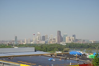
South Calgary is a residential neighbourhood in the southwest quadrant of Calgary, Alberta. It is located between 14th St west and Crowchild Trail. The community has an area redevelopment plan in place.
Crescent Heights is a diverse, vibrant neighbourhood located in Calgary, Alberta. It is located in the inner city, immediately north from Downtown. It is bounded to the north by the Trans-Canada Highway, on the east by Edmonton Trail, on the west by 4th Street NW, and to the south by Memorial Drive and the Bow River.
Richmond is a residential neighbourhood in the southwest quadrant of Calgary, Alberta.
Banff Trail is a residential neighbourhood in the northwest quadrant of Calgary, Alberta. It is located northeast of the intersection of Crowchild Trail and Trans-Canada Highway, east of McMahon Stadium and the University of Calgary. The Banff Trail station of the C-train LRT system serves the community, which contains a large motel village in the southwest corner.
Applewood Park is a residential neighbourhood in the southeast quadrant of Calgary, Alberta. It is located at the eastern edge of the city, north of 17 Avenue SE. Elliston Park, the site of GlobalFest fireworks, is located southwest of the community.
Ramsay is a residential neighbourhood in the southeast quadrant of Calgary, Alberta. It is an inner city community, located east of the Elbow River, Macleod Trail, Stampede Grounds and the Scotiabank Saddledome arena and south of Inglewood. To the southeast, it borders the Alyth-Bonny Brook industrial area. The eastern half of the community consists primarily of older homes and there is an industrial area in the most eastern corner of the community.
Winston Heights/Mountview is a residential neighbourhood in the northeast quadrant of Calgary, Alberta. It is bounded by 32 Avenue to the north, the Nose Creek and Deerfoot Trail to the east, Trans-Canada Highway to the south and Edmonton Trail to the west. Fox Hollow Golf Course and The Winston Golf Club are developed at the eastern edge of the neighbourhood.
Windsor Park is a residential neighbourhood in the southwest quadrant of Calgary, Alberta. It is bounded by 50 Avenue S to the north, Macleod Trail to the east, 58 Avenue S to the south and the Calgary Golf & Country Club and Elbow River to the west. Chinook Centre is located southeast of the neighbourhood.
Parkhill/Stanley Park is a residential neighbourhood in the southwest quadrant of Calgary, Alberta. It is bounded by Mission Road to the north, Macleod Trail to the east, Crescent Boulevard to the south and the Elbow River to the west. The Roxboro Park borders the community to the north and Stanley Park is established in the Elbow River valley.

Cliff Bungalow is an inner city residential neighbourhood in the southwest quadrant of Calgary, Alberta. Centered along 5 Street SW, it is bordered by Elbow River to the south, by Uptown 17th Avenue to the north and by Fourth Street to the east.
Roxboro is an inner city residential neighbourhood in the southwest quadrant of Calgary, Alberta, Canada. It is bounded to the north and west by the Elbow River and to the south by 33 Avenue SW of Roxboro, in a bend of the Elbow River, lies the community of Rideau Park.
Highland Park is a residential neighbourhood in the northwest quadrant of Calgary, Alberta. It is bounded to the north by McKnight Boulevard, to the east by Edmonton Trail, to the south by 32 Avenue N and to the west by 4 Street W. Confederation Park and Nose Hill Park are located in close proximity. The Queens Park Cemetery occupies the southwestern corner of the neighbourhood, and the Highland golf course is developed in the north.
CFB Currie is a residential neighbourhood in the southwest quadrant of Calgary, Alberta, Canada. It is located on former Canadian Forces Base (CFB) Calgary, bounded by the Lincoln Park community to the southwest, Sarcee Road S.W. to the west, 33 Avenue S.W. to the north, and Crowchild Trail to the east. Being part of former CFB Calgary, the neighbourhood is planned for redevelopment under the CFB West Master Plan by Canada Lands Company.

