Amicus Mountain

Last updated
Amicus Mountain
Amicus Mountain.jpg
Northeast aspect
Highest point
Elevation 2,510 m (8,235 ft) [1]
Prominence 365 m (1,198 ft) [1]
Parent peak Ashlu Mountain (2,561 m) [2]
Isolation 6.22 km (3.86 mi) [1]
Listing Mountains of British Columbia
Coordinates 50°03′06″N123°28′16″W / 50.05167°N 123.47111°W / 50.05167; -123.47111 [1]
Geography
Canada British Columbia relief location map.jpg
Red triangle with thick white border.svg
Amicus Mountain
Location in British Columbia
Canada relief map 2.svg
Red triangle with thick white border.svg
Amicus Mountain
Amicus Mountain (Canada)
Country Canada
Province British Columbia
District New Westminster Land District
Parent range Coast Mountains
Topo map NTS 92J3 Brandywine Falls

Amicus Mountain is a 2,510-metre (8,235-foot) glaciated summit in British Columbia, Canada.

Contents

Description

Amicus Mountain is located in the Coast Mountains, 37 kilometres (23 mi) west-southwest of Whistler and 1.52 kilometres (0.94 mi) west-northwest of Icecap Peak, which is the nearest neighbor. [1] Precipitation runoff and glacial meltwater from this mountain drains into tributaries of the Squamish River. Amicus Mountain is more notable for its rise above local terrain than for its absolute elevation as topographic relief is significant with the summit rising 2,410 metres (7,907 ft) above the Squamish River in nine kilometres (5.6 mi) and 1,960 metres (6,430 ft) above Ashlu Creek in seven kilometres (4.3 mi). "Amicus" is the Latin word for "friend." The mountain's toponym has not been officially adopted by the Geographical Names Board of Canada.

Icecap Peak (left) and Amicus Mountain (right) 20240318063711!Icecap Peak, British Columbia.jpg
Icecap Peak (left) and Amicus Mountain (right)

Climate

Based on the Köppen climate classification, Amicus Mountain is located in the marine west coast climate zone of western North America. [3] Most weather fronts originate in the Pacific Ocean, and travel east toward the Coast Mountains where they are forced upward by the range (orographic lift), causing them to drop their moisture in the form of rain or snowfall. As a result, the Coast Mountains experience high precipitation, especially during the winter months in the form of snowfall. Winter temperatures can drop below −20 °C with wind chill factors below −30 °C. This climate supports unnamed glaciers surrounding the peak. The months July through September offer the most favorable weather for climbing Amicus Mountain.

See also

Related Research Articles

<span class="mw-page-title-main">Mount Callaghan</span> Mountain in British Columbia, Canada

Mount Callaghan is a volcanic peak located east of the headwaters of the Squamish River, just northeast of the Powder Mountain Icefield and just south of the Pemberton Icefield in the Sea to Sky Country of southwestern British Columbia, Canada, about 20 km directly west of the Resort Municipality of Whistler. A crack was observed across Callaghan's summit in the spring of 1999. In 2000, a section of the summit collapsed. Callaghan Lake lies below the south face of the mountain.

<span class="mw-page-title-main">Mount Jimmy Jimmy</span> Mountain in British Columbia, Canada

Mount Jimmy Jimmy is a 2,208-metre (7,244 ft) glaciated mountain located in the Coast Mountains in southwestern British Columbia, Canada. It is situated 32 kilometres (20 mi) northwest of Squamish, and 10 km (6 mi) northwest of Ossa Mountain, which is its nearest higher peak. Mt. Jimmy Jimmy is the highest point of the Tzoonie-Clowhom Divide. Precipitation runoff from the peak and meltwater from its immense glaciers drains into tributaries of the Squamish River and Clowhom River. The mountain was named for Chief Jimmy Jimmy, a leader of the Squamish Nation, who had traplines in the vicinity of the mountain and was a skilled paddler. The mountain's name was officially adopted on June 6, 1957, by the Geographical Names Board of Canada.  

<span class="mw-page-title-main">Lydia Mountain</span>

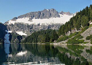
Lydia Mountain is a 2,100-metre (6,890-foot) summit located in the Tantalus Range, in Tantalus Provincial Park, in southwestern British Columbia, Canada. It is situated 14.5 km (9 mi) northwest of Squamish, and 5.46 km (3 mi) south-southeast of Mount Tantalus, which is the highest peak in the Tantalus Range. The nearest higher neighbor is The Red Tusk, 0.5 km (0 mi) to the west, and Mount Niobe lies 2.17 km (1 mi) to the east-southeast. Lake Lovely Water lies below the eastern slope of the peak and precipitation runoff from the peak drains east to the Squamish River, and west to the Clowhom River via Red Tusk Creek. Topographic relief is significant as Lydia Mountain rises 1,400 meters (4,600 feet) above Red Tusk Creek in approximately three kilometers (two miles). The mountain's name was officially adopted on June 6, 1957, by the Geographical Names Board of Canada. The mountain was named for mythic Lydia, of which Tantalus was a primordial ruler in Greek mythology. Several peaks in the Tantalus Range are named in association with Tantalus. The first ascent of Lydia Mountain was made in 1914 by Basil Darling and Allan Morkill.

<span class="mw-page-title-main">Antimony Mountain</span> Mountain in British Columbia, Canada

Antimony Mountain is a 2,668-metre (8,753-foot) mountain summit located in British Columbia, Canada.

<span class="mw-page-title-main">Rhododendron Mountain</span> Mountain in British Columbia, Canada

Rhododendron Mountain is a 2,523-metre (8,278-foot) glaciated summit in British Columbia, Canada.

<span class="mw-page-title-main">Cloudraker Mountain</span> Mountain in British Columbia, Canada

Cloudraker Mountain is a 2,385-metre (7,825-foot) glaciated summit in British Columbia, Canada.

Whitecap Mountain is a 2,918-metre (9,573-foot) summit in British Columbia, Canada.

<span class="mw-page-title-main">Mount Sir Richard</span> Mountain in British Columbia, Canada

Mount Sir Richard is a 2,681-metre (8,796-foot) glaciated summit in British Columbia, Canada.

<span class="mw-page-title-main">In-SHUCK-ch Mountain</span> Mountain in British Columbia, Canada

In-SHUCK-ch Mountain is a 2,386-metre (7,828-foot) summit in British Columbia, Canada.

<span class="mw-page-title-main">The Lecture Cutters</span> Mountains in British Columbia, Canada

The Lecture Cutters are 2,524-metre (8,281-foot) mountain peaks in British Columbia, Canada.

<span class="mw-page-title-main">Outlier Peak</span> Mountain in British Columbia, Canada

Outlier Peak is a 2,422-metre (7,946-foot) mountain summit in British Columbia, Canada.

<span class="mw-page-title-main">Nivalis Mountain</span> Mountain in British Columbia, Canada

Nivalis Mountain is a 2,659-metre (8,724-foot) mountain summit in British Columbia, Canada.

<span class="mw-page-title-main">Mount Neal</span> Mountain in British Columbia, Canada

Mount Neal is a 2,552-metre (8,373-foot) glaciated summit in British Columbia, Canada.

<span class="mw-page-title-main">Carcajou Peak</span> Mountain in British Columbia, Canada

Carcajou Peak is a 2,239-metre (7,346-foot) mountain summit in British Columbia, Canada.

<span class="mw-page-title-main">Mount Moe</span> Mountain in British Columbia, Canada

Mount Moe is a 2,664-metre (8,740-foot) glaciated summit in British Columbia, Canada.

<span class="mw-page-title-main">Twin Goat Mountain</span> Mountain in British Columbia, Canada

Twin Goat Mountain is a 2,128-metre (6,982-foot) summit in British Columbia, Canada.

<span class="mw-page-title-main">Icecap Peak</span> Mountain in British Columbia, Canada

Icecap Peak is a 2,435-metre (7,989-foot) glaciated summit in British Columbia, Canada.

<span class="mw-page-title-main">Mount Evans (British Columbia)</span> Mountain in British Columbia, Canada

Mount Evans is a 2,250-metre (7,382-foot) glaciated summit in British Columbia, Canada.

<span class="mw-page-title-main">Tzoonie Mountain</span> Mountain in British Columbia, Canada

Tzoonie Mountain is a 2,123-metre (6,965-foot) summit in British Columbia, Canada.

<span class="mw-page-title-main">Mount Pitt</span> Summit in British Columbia, Canada

Mount Pitt is a 2,487-metre (8,159-foot) summit in British Columbia, Canada.

References

  1. 1 2 3 4 5 "Amicus Mountain, British Columbia". Peakbagger.com. Retrieved 2024-03-19.
  2. "Amicus Mountain, Peakvisor.com" . Retrieved 2024-03-19.
  3. Peel, M. C.; Finlayson, B. L.; McMahon, T. A. (2007). "Updated world map of the Köppen−Geiger climate classification" (PDF). Hydrol. Earth Syst. Sci. 11 (5): 1633. Bibcode:2007HESS...11.1633P. doi: 10.5194/hess-11-1633-2007 . ISSN   1027-5606.