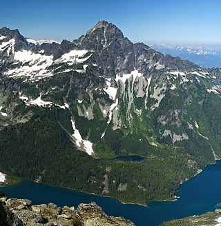
Alpha Mountain is a 2,302-metre (7,552-foot) summit located in the Tantalus Range, in Tantalus Provincial Park, in southwestern British Columbia, Canada. It is situated 14 km (8.7 mi) northwest of Squamish, and 4.6 km (2.9 mi) southeast of Mount Tantalus, which is the highest peak in the Tantalus Range. Its nearest higher peak is Serratus Mountain, 1.9 km (1.2 mi) to the west. The Serratus Glacier lies to the west of Alpha, unnamed glaciers lie on the northern and eastern slopes, and Lake Lovely Water lies below the south slope. Precipitation runoff from the peak drains into tributaries of the Squamish River.

Mount Niobe is a 2,021-metre (6,631-foot) summit located in the Tantalus Range, in Tantalus Provincial Park, in southwestern British Columbia, Canada. It is situated 10 km (6 mi) northwest of Squamish, and 7.2 km (4 mi) southeast of Mount Tantalus, which is the highest peak in the Tantalus Range. Its nearest higher peak is Lydia Mountain, 2.03 km (1 mi) to the west-northwest, and Omega Mountain lies 1.1 km (1 mi) to the east. Lake Lovely Water lies below the northern slope of the peak and precipitation runoff from the peak drains into tributaries of the Squamish River. The first ascent of the mountain was made in 1910 by E. Kingsford-Smith and G. Warren via the south side. The mountain's name was officially adopted on June 6, 1957, by the Geographical Names Board of Canada. The mountain was named for Niobe, daughter of Tantalus in Greek mythology, with several peaks in the Tantalus Range being named for family members of Tantalus.

Mount Thyestes is a 1,697-metre (5,568-foot) mountain summit located in the Tantalus Range, in Tantalus Provincial Park, in southwestern British Columbia, Canada. It is situated 4 km (2 mi) immediately west of Brackendale, 7 km (4 mi) northwest of Squamish, and 10.7 km (7 mi) southeast of Mount Tantalus, which is the highest peak in the Tantalus Range. Its nearest higher peak is Omega Mountain, 2.4 km (1 mi) to the northwest, and Mount Pelops lies 3.6 km (2 mi) to the west-northwest. Precipitation runoff from the peak drains into tributaries of the Squamish River. The first ascent of the mountain was made in 1942 by R. McLellan, H. Parliament, and F. Roots. The mountain was named for Thyestes, son of Pelops and grandson of Tantalus according to Greek mythology. The mountain's name was officially adopted on June 6, 1957, by the Geographical Names Board of Canada.

Pelion Mountain is a 2,312-metre (7,585-foot) summit located in the Tantalus Range, in Tantalus Provincial Park, in southwestern British Columbia, Canada. It is situated 21 km (13 mi) northwest of Squamish, 0.8 km (0 mi) east of Ossa Mountain, and 5.5 km (3 mi) north-northwest of Mount Tantalus, which is its nearest higher peak and the highest peak in the Tantalus Range. Unnamed glaciers surround the peak and precipitation runoff from the peak drains into tributaries of the Squamish River and Clowhom River. The first ascent of the mountain was made in 1944 by V. Brink and B. McLellan. The mountain names in the Tantalus Range have a Greek mythology theme, and Pelion Mountain was named for the legendary Pelion mountain in Thessaly, upon which the Aloadaes are said to have attempted to pile Mount Pelion on top of Mount Ossa in their attempt to scale Olympus, home of the Greek gods. The mountain's name was officially adopted on June 6, 1957, by the Geographical Names Board of Canada.
Rhododendron Mountain is a 2,523-metre (8,278-foot) glaciated summit in British Columbia, Canada.

Cloudraker Mountain is a 2,385-metre (7,825-foot) glaciated summit in British Columbia, Canada.
Whitecap Mountain is a 2,918-metre (9,573-foot) summit in British Columbia, Canada.

Mount Sir Richard is a 2,681-metre (8,796-foot) glaciated summit in British Columbia, Canada.

In-SHUCK-ch Mountain is a 2,386-metre (7,828-foot) summit in British Columbia, Canada.

The Lecture Cutters are 2,524-metre (8,281-foot) mountain peaks in British Columbia, Canada.

Outlier Peak is a 2,422-metre (7,946-foot) mountain summit in British Columbia, Canada.

Nivalis Mountain is a 2,659-metre (8,724-foot) mountain summit in British Columbia, Canada.

Mount Neal is a 2,552-metre (8,373-foot) glaciated summit in British Columbia, Canada.
Carcajou Peak is a 2,239-metre (7,346-foot) mountain summit in British Columbia, Canada.

Mount Moe is a 2,664-metre (8,740-foot) glaciated summit in British Columbia, Canada.

Twin Goat Mountain is a 2,128-metre (6,982-foot) summit in British Columbia, Canada.

Amicus Mountain is a 2,510-metre (8,235-foot) glaciated summit in British Columbia, Canada.

Mount Evans is a 2,250-metre (7,382-foot) glaciated summit in British Columbia, Canada.

Tzoonie Mountain is a 2,123-metre (6,965-foot) summit in British Columbia, Canada.

Mount Pitt is a 2,487-metre (8,159-foot) summit in British Columbia, Canada.


