Angarrack

Last updated

Angarrack
AngharrackRailwayViaductCornwallUK.jpg
Angarrack village under the railway viaduct
Cornwall UK mainland location map.svg
Red pog.svg
Angarrack
Location within Cornwall
OS grid reference SW584382
Unitary authority
Ceremonial county
Region
Country England
Sovereign state United Kingdom
Post town HAYLE
Postcode district TR27
Dialling code 01736
Police Devon and Cornwall
Fire Cornwall
Ambulance South Western
UK Parliament
List of places
UK
England
Cornwall
50°11′38″N5°23′10″W / 50.194°N 05.386°W / 50.194; -05.386 Coordinates: 50°11′38″N5°23′10″W / 50.194°N 05.386°W / 50.194; -05.386

Angarrack (Cornish : An Garrek) is a village in west Cornwall, England, UK. It is in the parish of Gwinear-Gwithian a mile to the east of Hayle. Immediately south of the village Angarrack viaduct carries the Cornish mainline railway over the Angarrack River. [1] The name comes from An Garrek which means "The Rock" in the Cornish language. According to the Ordnance Survey the spelling is Angarrack but on signs near the village, it is variously spelled Angarrack, Angharrack, or Angarrick.

Contents

Geography

Angarrack is in a narrow valley from which the Angarrack River flows before entering the Copperhouse Pool in Hayle, through a specially constructed culvert designed to prevent flooding. However, in January 2003 the flooding was severe enough to be reported on the regional television programme Spotlight .[ citation needed ] The Angarrack River joins the Hayle Estuary at Copperhouse Pool before running into the sea at St Ives Bay. [1]

History

A mill known as Melynbran was recorded in 1342 and may be the mill, Conarditone, recorded in Domesday. [2] Angarrack is shown on maps as far back as the sixteenth century. The village was formerly a centre of industry with mining and quarrying and there were a number of mines in the valley of the Angarrack River. At the western end of the railway viaduct was the Mellanvrane mine where, before 1728, Dr John Woodward collected several specimens of tin for his mineral collection. At the eastern end of the viaduct was the Mellanoweth Mine where the North Deep Adit (a drainage and exploratory tunnel) continued to the Nanpusker Mine, further up the valley. An 1846 project to continue the adit up the valley as far as Binner Downs, just to the east of Leedstown, does not appear to have occurred. [3]

There were also four mills on the Angarrack River. One was at Trungle; one (Angarrack Mill) was at the far end of the village on the junction of Grist Lane formally known as (the fields) and Steamer's Hill; one (Grist Mill) was situated at the northern end of the village; and one (Loggans Mill) still stands beside the Angarrack River at the eastern end of Hayle. [4] [5] [6] A smelting house was built in 1704 and the mill(s) were converted into stamps to process ores from the nearby mines. The smelting house closed in 1881 and the only remaining structures are the manager's house, smith shop and tin house which have been converted to other uses [7]

The main road between Redruth and the west once passed through Angarrack. Charles Wesley, following a visit to Redruth on 7 August 1743, was returning to St Ives via Angarrack and stopped to preach to a group of people who were at Velling-Varine (Mellenvrane). It is not known when a Methodist Society formed but the first mention is in 1779 when Angarrack was part of the Redruth Circuit. [8] The first chapel was built in 1843 and the present chapel was built in a quarry, near the smelting house and opened on 10 April 1874. A Sunday School was added in 1889 and Vestries in 1926. [9]

Hayle Railway

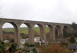
In 1834 the Hayle Railway built a 4-foot 8½ inch gauge track, over the 9.5 miles (15.3 km) from Hayle to Redruth. Above Angarrack originally horses, and from 1843 a stationary engine, hauled the trains up and down an incline. [10] [11] The incline can still be seen on maps and the stationary engine is commemorated in the name Steamers Hill; the road leading to Connor Downs. [1] Following acquisition by the West Cornwall Railway a new line was constructed from Penzance to Trenowin Farm, to the east of Angarrack and the old line through Hayle and Angarrack was closed on 16 February 1852. [12] The new line bypassed the original Hayle Station and the incline by wooden viaducts built between 1850 and 1852. The present 11-span viaduct was built in 1888 for Great Western Railway beside the original viaduct. [13]

See also

Related Research Articles

Hayle Town in Cornwall, United Kingdom

Hayle is a port town and civil parish in west Cornwall, United Kingdom. It is situated at the mouth of the Hayle River and is approximately seven miles (11 km) northeast of Penzance.

Gwithian Human settlement in England

Gwithian is a coastal village in west Cornwall, England. It is three miles (5 km) north-east of Hayle and four miles (6.5 km) east of St Ives, Cornwall across St Ives Bay. Gwithian is in the civil parish of Gwinear-Gwithian.

Gwinear–Gwithian Coastal civil parish in west Cornwall, England

Gwinear–Gwithian is a coastal civil parish in west Cornwall, England, United Kingdom. It includes the villages of Connor Downs, Gwinear, Gwithian, Reawla and Rosewarne. The parish is situated approximately two miles (3 km) east of Hayle two miles (3 km) west of Camborne.

Redruth railway station Railway station in Cornwall, England

Redruth station serves the town of Redruth, Cornwall, United Kingdom, and is situated on the Cornish Main Line between Truro and Camborne. The station is 310 miles (500 km) from London Paddington via Bristol Temple Meads.

Camborne and Redruth (UK Parliament constituency) UK Parliament constituency since 2010

Camborne and Redruth is a parliamentary constituency in the United Kingdom. The seat is in Cornwall on the South West Peninsula of England, and is currently represented by the Conservative Environment Secretary George Eustice.

Portreath Human settlement in England

Portreath is a civil parish, village and fishing port on the north coast of Cornwall, England, United Kingdom. The village is about three miles (5 km) northwest of Redruth. The village extends along both sides of a stream valley and is centred on the harbour and beach. West of the harbour entrance and breakwater are two sandy beaches that are popular with holidaymakers, surfers and naturists.

Penwith Hundred Ancient administrative unit of Cornwall, England

Penwith Hundred was one of ten ancient administrative hundreds of the county of Cornwall, England, UK. The ancient hundred of Penwith was larger than the local government district of Penwith (1974–2009) which took its name. Daphne du Maurier in Vanishing Cornwall suggests that the name, Penwith, has three renderings, "the last promontory," "promontory on the left, and "the headland of slaughter," thus suggesting that this area might have been the site of prehistoric invasions of sea-borne fighters, or perhaps tribal battles. The eastern part became part of Kerrier District.

Gwennap Human settlement in England

Gwennap is a village and civil parish in Cornwall, England. It is about five miles (8 km) southeast of Redruth. Hamlets of Burncoose, Comford, Coombe, Crofthandy, Cusgarne, Fernsplatt, Frogpool, Goon Gumpas Hick's Mill, Tresamble and United Downs lie in the parish, as does Little Beside country house.

The West Cornwall Railway was a railway company in Cornwall, Great Britain, formed in 1846 to construct a railway between Penzance and Truro. It purchased the existing Hayle Railway, and improved its main line, and built new sections between Penzance and Hayle, and between Redruth and Truro, and opened throughout in 1852.

The Towans

Towan is found in many placenames in Cornwall. However, The Towans usually refers to the three-mile (5 km) stretch of coastal dunes which extends north-east from the estuary of the River Hayle to Gwithian beach with a midpoint near Upton. The South West Coast Path crosses the towans.

Hayle Estuary Estuary in Cornwall, England

The Hayle Estuary is an estuary in west Cornwall, England, United Kingdom. It is one of the few natural harbours on the north coast of south-west England and during the prehistoric and early medieval periods was important for trade and the movement of people and ideas.

Hayle Railway

The Hayle Railway was an early railway in West Cornwall, constructed to convey copper and tin ore from the Redruth and Camborne areas to sea ports at Hayle and Portreath. It was opened in 1837, and carried passengers on its main line from 1843.

There are seventeen disused railway stations on the Cornish Main Line between Plymouth in Devon and Penzance in Cornwall, England. The remains of nine of these can be seen from passing trains. While a number of these were closed following the so-called "Beeching Axe" in the 1960s, many of them had been closed much earlier, the traffic for which they had been built failing to materialise.

Joseph Austen Treffry was an engineer, mining adventurer, and industrialist who became a significant landowner in Cornwall, England.

Penponds Viaduct is a railway viaduct which carries the Cornish Main Line west of Camborne in Cornwall, England. It crosses over a small valley containing the southern arm of the Red River, and a minor road known as Viaduct Lane.

Angarrack viaduct

Angarrack railway viaduct crosses the valley of the Angarrack River at Angarrack in west Cornwall, United Kingdom.

Gwinear, Cornwall Human settlement in England

Gwinear is a small village in west Cornwall, England, UK. It is about two miles (3 km) east of Hayle and overlooks the Angarrack valley. It is in the civil parish of Gwinear-Gwithian.

Penponds Human settlement in England

Penponds is a village west of Camborne, in west Cornwall, UK.

Presented below is an alphabetical index of articles related to Cornwall:

Hayle North (electoral division) Electoral division of Cornwall in the UK

Hayle North was an electoral division of Cornwall in the United Kingdom which returned one member to sit on Cornwall Council between 2009 to 2021. It was abolished at the 2021 local elections, being succeeded by Gwinear-Gwithian and Hayle East and Hayle West.

References

  1. 1 2 3 OS Explorer Land's End (Map). Southampton: Ordnance Survey. 2015. ISBN   978 0 319 24304 6.
  2. Historic England. "Monument No. 424710". Research records (formerly PastScape). Retrieved 13 January 2017.
  3. Hamilton Jenkin, A K (1980). Mines and Miners of Cornwall 5. Hayle, Gwinear & Gwithian. Bracknell: Forge Books. pp. 14–15. ISBN   0-904662-10-1.
  4. "Angarrack". Cornwall Guide. 2 December 2015. Retrieved 13 January 2017.
  5. Historic England. "Trungle Mill (424758)". Research records (formerly PastScape). Retrieved 13 January 2017.
  6. Historic England. "Loggans Mill (1348409)". Research records (formerly PastScape). Retrieved 13 January 2017.
  7. Historic England. "Angarrack Smelting House (424712)". Research records (formerly PastScape). Retrieved 13 January 2017.
  8. Guiver, Dawn. "Wesleyanism in Angarrack". Angarrack Life. Retrieved 13 January 2017.
  9. Guiver, Dawn. "Angarrack Chepel". Angarrack Life. Retrieved 13 January 2017.
  10. Woodfin, R J (1972). The Cornwall Railway To Its Centenary In 1959. Truro: Bradford Barton. p. 1. ISBN   978-0851530857.
  11. Historic England. "Hayle Railway (424708)". Research records (formerly PastScape). Retrieved 13 January 2017.
  12. Oakley, Mike (2009). Cornwall Railway Stations. Wimborne Minster: Dovecote Press. ISBN   978-1-904-34968-6.
  13. Historic England. "The Viaduct At SW58353801 (1143709)". National Heritage List for England . Retrieved 13 January 2017.

Commons-logo.svg Media related to Angarrack at Wikimedia Commons