Bolingbrook's Clow International Airport is a public airport in Bolingbrook, a village in Will County, Illinois, United States. Located 29 miles (46 km) southwest of the Chicago Loop, it is a small general aviation facility catering to private pilots, students, and commuter aircraft.

Central Illinois Regional Airport at Bloomington–Normal is a public airport in McLean County, Illinois, three miles east of Bloomington and southeast of Normal. Owned by the Bloomington–Normal Airport Authority, it is also known as Central Illinois Regional Airport (CIRA).

Chicago Executive Airport, formerly Palwaukee Municipal Airport, is a public airport 18 miles (33 km) northwest of Chicago, in the village of Wheeling in Cook County, Illinois, United States. It is owned by the City of Prospect Heights and the Village of Wheeling.

Westfield-Barnes Regional Airport is a joint civil-military airport in Hampden County, Massachusetts, three miles (6 km) north of Westfield and northwest of Springfield. It was formerly Barnes Municipal Airport; the National Plan of Integrated Airport Systems for 2011–2015 categorized it as a general aviation facility. Westfield-Barnes is one of Massachusetts' largest airports with a strong flight training, general aviation, and military presence. It is also known as Barnes Air National Guard Base.
Aurora Municipal Airport, also known as Al Potter Field, is a public airport located two miles (3 km) north of the central business district of Aurora, a city in Hamilton County, Nebraska, United States. It is owned by Aurora Airport Authority.

Charlevoix Municipal Airport is a city-owned, public-use airport located one nautical mile (2 km) southwest of the central business district of Charlevoix, a city in Charlevoix County, Michigan, United States. It is mostly used for general aviation, but also offers passenger service to Beaver Island via Island Airways and Fresh Air Aviation.
Lewis University Airport is a public use airport located 20 miles (32 km) southwest of Chicago, in the village of Romeoville in Will County, Illinois, United States. The Joliet Regional Port District assumed ownership of the airport in 1989. The National Weather Service Chicago, Illinois is adjacent to the airport.
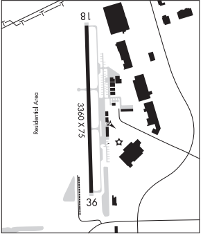
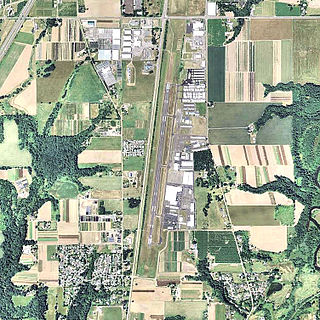
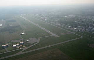
Lansing Municipal Airport is a public airport located 21 miles (34 km) south of Chicago, in Lansing, a village in Cook County, Illinois, United States. It is owned by the Village of Lansing.
Coles County Memorial Airport is a public use airport between Mattoon and Charleston in Coles County, Illinois. Owned by the Coles County Airport Authority, it is five miles east of Mattoon and six miles west of Charleston. The National Plan of Integrated Airport Systems for 2011–2015 called it a general aviation facility.

Meriden Markham Municipal Airport is a public-use airport located three miles (5 km) southwest of the central business district of Meriden, a city in New Haven County, Connecticut, United States. This general aviation airport is owned by City of Meriden. It is included in the Federal Aviation Administration (FAA) National Plan of Integrated Airport Systems for 2017–2021, in which it is categorized as a local general aviation facility.
Aurora State Airport is a public airport located one mile (2 km) northwest of the central business district of Aurora, a city in Marion County, Oregon, United States. It is owned by the Oregon Department of Aviation.
Plant City Airport is a public-use airport located two nautical miles (4 km) southwest of the central business district of Plant City in Hillsborough County, Florida, United States. The airport is publicly owned by the Hillsborough County Aviation Authority, which also operates Tampa International Airport. It was formerly known as Plant City Municipal Airport. It supports a 400-acre (1.6 km2) industrial park located about one mile (1.6 km) east of the airport.
Elkhart Municipal Airport is a city-owned public-use airport located three nautical miles (6 km) northwest of the central business district of Elkhart, a city in Elkhart County, Indiana, United States.

Stevens Point Municipal Airport is a public airport located three miles (5 km) northeast of the central business district of Stevens Point, a city in Portage County, Wisconsin, United States. It is owned and operated by the city of Stevens Point. It is included in the Federal Aviation Administration (FAA) National Plan of Integrated Airport Systems for 2025–2029, in which it is categorized as a local general aviation facility.
Mount Pleasant Municipal Airport is a city-owned public-use airport located two miles (3 km) northeast of the central business district of Mount Pleasant, a city in Isabella County, Michigan, United States. The airport became active in 1940. It serves general aviation for Mount Pleasant and the surrounding area. It is included in the Federal Aviation Administration (FAA) National Plan of Integrated Airport Systems for 2017–2021, in which it is categorized as a local general aviation facility.
Fairfield Municipal Airport is a city-owned, public-use airport located two nautical miles (3.7 km) west of the central business district of Fairfield, in Wayne County, Illinois. According to the FAA's National Plan of Integrated Airport Systems for 2009 to 2013, it was classified as a general aviation airport.
Rochelle Municipal Airport, also known as Koritz Field, is a city-owned public-use airport located two nautical miles south of the central business district of Rochelle, a city in Ogle County, Illinois, United States. It is included in the FAA's National Plan of Integrated Airport Systems for 2011–2015, which categorized it as a general aviation facility.
Cambridge Municipal Airport is three miles south of Cambridge, in Guernsey County, Ohio. The FAA's National Plan of Integrated Airport Systems for 2011–2015 categorized it as a general aviation facility.
Centralia Municipal Airport is a U.S. general aviation airport located two nautical miles southeast of Centralia, Illinois.
Appleton Municipal Airport, is a public use airport located 2 miles (3 km) northeast of the central business district of Appleton, a city in Swift County, Minnesota, United States. The closest airport with commercial airline service is Watertown Regional Airport about 60 miles (97 km) to the southwest.
 Aurora Municipal Airport (west side)
 Air Classics Museum building
 Air Classics Museum display


