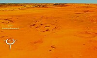
The Arkenu structures, also known as the Arkenu craters, are a pair of prominent circular geological structures in eastern Libya. The structures are approximately 10 kilometres (6.2 mi) and 6.8 kilometres (4.2 mi) in diameter, and lie about 70 kilometres (43 mi) west of Jabal Arkanu on the eastern margin of the al-Kufrah Basin.

Elbow is a meteorite crater just north of the village of Riverhurst in Saskatchewan, Canada.

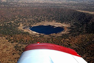
Mistastin crater is a meteorite crater in Labrador, Canada which contains the roughly circular Mistastin Lake. The lake is approximately 16 km (9.9 mi) in diameter, while the estimated diameter of the original crater is 28 km (17 mi). The age of the crater is calculated to be 36.6 ± 2 million years (Eocene).
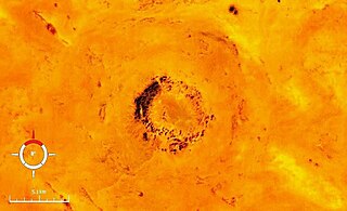
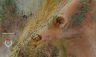
Oasis is a meteorite crater in Libya. The crater is exposed at the surface, and has been significantly eroded. The prominent topographic ring is only the central uplift, which is about 5.2 kilometres (3.2 mi) in diameter, while the original crater rim is estimated to have been 18 kilometres (11 mi) in diameter. The age is estimated to be less than 120 million years.

Puchezh-Katunki is a meteor crater located in the Nizhny Novgorod Oblast of the Volga Federal District, Russia. It is 80 km (50 mi) in diameter. Argon–argon dating has constrained the age of formation to be 195.9 ± 1.0 million years old, placing it within the Sinemurian stage of the Early Jurassic. The crater is not exposed to the surface, but appears as variation in the vegetation. The Earth Impact Database lists a rim-to-rim diameter of 40 kilometres (25 mi).
Saint Martin is an impact structure in Manitoba, Canada. It is located in the northern part of the Rural Municipality of Grahamdale, northwest of Lake St. Martin.

Shoemaker is an impact structure, the deeply eroded remnant of a former impact crater, situated in arid central Western Australia, about 100 km (62 mi) north-northeast of Wiluna. It is named in honour of planetary geologist Eugene Shoemaker.
Steen River is an impact structure in Alberta, Canada. It is 25 km (16 mi) in diameter and the age is estimated to be 91 ± 7 million years. The structure is not exposed at the surface. The original crater was partially eroded prior to burial, and lies under 200 m (660 ft) of sediments.

Strangways is a large impact structure, the eroded remnant of a former impact crater, located in the Northern Territory of Australia about 65 kilometres (40 mi) east-south-east of the town of Mataranka. It was named after the nearby Strangways River. The location is remote and difficult to access. Its age has been determined as approximately 646 Ma.

Suvasvesi is a lake in Eastern Finland near the city of Kuopio. Suvasvesi consists of two circular open lakes, Kuukkarinselkä in north and Haapaselkä in south. The lakes are separated by a group of islands. The lake has 688 islands in total. The area of the lake is 234 square kilometres (90 sq mi) making it the 18th largest lake in Finland. Kuukkarinselkä is the third deepest lake in Finland measuring 89.0 metres (292.0 ft) in the deepest point.
Tswaing is an impact crater enclosed by a 1,946 ha nature reserve, situated in northern Gauteng province, South Africa. The crater and reserve are situated on a base of ancient granite of the Bushveld Igneous Complex, some 40 km to the north-northwest of Pretoria. This astrobleme is 1.13 km in diameter and 100 m deep and its age is estimated to be 220,000 ± 52,000 years (Pleistocene). The impactor is believed to have been a chondrite or stony meteorite some 30 to 50 m in diameter that was vaporised during the impact event. Morokweng impact structure, another South African crater of chondrite origin, lies north-west of Vryburg. Since 1996 it falls under the auspices of Ditsong Museums of South Africa.
Viewfield is an impact crater in Saskatchewan, Canada. It is 2.5 kilometres (1.6 mi) in diameter and the age is estimated to be 190 ± 20 million years. The crater is not exposed at the surface.

Kebira Crater is the name given to a circular topographic feature that was identified in 2007 by Farouk El-Baz and Eman Ghoneim using satellite imagery, Radarsat-1, and Shuttle Radar Topography Mission (SRTM) data in the Sahara desert. This feature straddles the border between Egypt and Libya. The name of this feature is derived from the Arabic word for "large", and also from its location near the Gilf Kebir region in southwest Egypt. Based solely on their interpretations of the remote sensing data, they argue that this feature is an exceptionally large, double-ringed, extraterrestrial impact crater. They suggest that the crater's original appearance has been obscured by wind and water erosion over time. Finally, they speculated that this feature might be the source of the yellow-green silica glass fragments, known as "Libyan desert glass", that can be found across part of Egypt's Libyan Desert. They neither conducted any fieldwork at this feature nor studied any samples collected from it. However, the Kebira Crater is currently not listed in the Earth Impact Database. Field trips to investigate the feature have found no supporting evidence. The "central uplift" clearly retains the horizontal bedding of the surrounding sandstone tableland, providing clear evidence against a possible impact origin.

The Earth Impact Database is a database of confirmed impact structures or craters on Earth. It was initiated in 1955 by the Dominion Observatory, Ottawa, under the direction of Carlyle S. Beals. Since 2001, it has been maintained as a not-for-profit source of information at the Planetary and Space Science Centre at the University of New Brunswick, Canada.
Dhala crater is an impact structure formed by an asteroid impact. It is situated near Bhonti village in Pichhore block of Shivpuri district of Madhya Pradesh state in India. It is the largest impact structure in India, and between the Mediterranean and Southeast Asia. The diameter of the structure is estimated at 3 kilometres (1.9 mi), while other sources estimate its diameter to be 11 km diameter. It is the second such structure found in India, after Lonar lake.

Traces of Catastrophe: A Handbook of Shock-Metamorphic Effects in Terrestrial Meteorite Impact Structures is a book written by Bevan M. French of the Smithsonian Institution. It is a comprehensive technical reference on the science of impact craters. It was published in 1998 by the Lunar and Planetary Institute (LPI), which is part of the Universities Space Research Association (USRA). It was originally available in hard copy from LPI, but is now only available as a portable document format (PDF) e-book free download.