El Paso is a city in and the county seat of El Paso County, Texas, United States. The 2020 population of the city from the U.S. Census Bureau was 678,815, making it the 22nd-most populous city in the U.S., the most populous city in West Texas, and the sixth-most populous city in Texas. Its metropolitan statistical area covers all of El Paso and Hudspeth counties in Texas, and had a population of 868,859 in 2020.

Del Rio is a city in and the county seat of Val Verde County in southwestern Texas, United States. As of 2020, Del Rio had a population of 34,673.
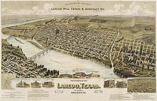
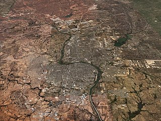
Laredo is a city in the U.S. state of Texas and the county seat of Webb County, on the north bank of the Rio Grande in South Texas, across from Nuevo Laredo, Tamaulipas, Mexico. Founded in 1755, Laredo grew from a village to the capital of the short-lived Republic of the Rio Grande to the largest inland port on the Mexican border. Laredo's economy is primarily based on international trade with Mexico, and as a major hub for three areas of transportation: land, rail, and air cargo. The city is on the southern end of I-35, which connects manufacturers in northern Mexico through Interstate 35 as a major route for trade throughout the U.S. It has four international bridges and one railway bridge.

The Lower Rio Grande Valley, commonly known as the Rio Grande Valley or locally as the Valley or RGV, is a region spanning the border of Texas and Mexico located in a floodplain of the Rio Grande near its mouth. The region includes the southernmost tip of South Texas and a portion of northern Tamaulipas, Mexico. It consists of the Brownsville, Harlingen, Weslaco, Donna, Pharr, McAllen, Edinburg, Mission, San Juan, and Rio Grande City metropolitan areas in the United States and the Matamoros, Río Bravo, and Reynosa metropolitan areas in Mexico. The area is generally bilingual in English and Spanish, with a fair amount of Spanglish due to the region's diverse history and transborder agglomerations. It is home to some of the poorest cities in the nation, as well as many unincorporated, persistent poverty communities called colonias. A large seasonal influx occurs of "winter Texans" — people who come down from the north for the winter and then return north before summer arrives.

Santos Benavides was a Confederate colonel during the American Civil War. Benavides was the highest-ranking Tejano soldier in the Confederate military.

South Texas is a geographic and cultural region of the U.S. state of Texas that lies roughly south of—and includes—San Antonio. The southern and western boundary is the Rio Grande, and to the east it is the Gulf of Mexico. The population of this region is more than 5 million according to the 2024 census estimates. The southern portion of this region is often referred to as the Rio Grande Valley. The eastern portion along the Gulf of Mexico is also referred to as the Coastal Bend.

Nuevo Laredo is a city in the Municipality of Nuevo Laredo in the Mexican state of Tamaulipas. The city lies on the banks of the Rio Grande, across from Laredo, United States. The 2010 census population of the city was 373,725. Nuevo Laredo is part of the Laredo-Nuevo Laredo Metropolitan Area with a population of 636,516. The municipality has an area of 1,334.02 km2 (515.07 sq mi). Nuevo Laredo is considered the “customs capital of Latin America” because of its high volume of international trade operations in the region, and number 1 in importance for US inland commercial traffic. Both the city and the municipality rank as the third largest in the state.

The Republic of the Rio Grande was one of a series of political movements in what was then Mexico which sought to become independent from the authoritarian, unitary government of Antonio López de Santa Anna; the Republic of Texas and the second Republic of Yucatán were created by political movements that pursued the same goal. The rebellion lasted from January 17 to November 6, 1840.
The flag of the Republic of the Rio Grande was used in 1840, during 283 days from January 17 to November 6, as long as the republic existed. This country was formed by the northeastern Mexican states of Coahuila, Nuevo León, and Tamaulipas. The flag was no longer used following the defeat of the Republic of the Rio Grande by Mexican troops.

Republic of the Rio Grande Museum is a historic house museum located in the downtown San Agustin de Laredo Historic District in Laredo, Texas, United States, next to the historic La Posada Hotel and San Agustín Cathedral. The Mexican vernacular structure was built in 1830 as a house with an addition in 1860. Among the people who have lived there was prominent rancher Bartolomé García, who was also one of Laredo's mayors, and who is a descendant of the town founder, Tomas Sanchez.
Laredo–Nuevo Laredo, otherwise known as the "Four-State Area" or the "Quad State Area", is one of six transborder agglomerations along the U.S.-Mexican border. The city of Laredo is situated in the U.S. state of Texas on the northern bank of the Rio Grande and Nuevo Laredo is located in the Mexican State of Tamaulipas in the southern bank of the river. This area is also known as the Two Laredos or the Laredo Borderplex. The area is made up of one county in the U.S and three municipalities in Mexico. Two urban areas, three cities, and 12 towns make the Laredo–Nuevo Laredo Metropolitan area. The two sides of the Borderplex are connected by four International Bridges and an International Railway Bridge. The Laredo–Nuevo Laredo Metropolitan area has a total of 636,516 inhabitants according to the INEGI Census of 2010 and the United States Census estimate of 2010. According to World Gazetteer this urban agglomeration ranked 157th largest in North and South America in 2010 with an estimated population of 675,481. This area ranks 66th in the United States and 23rd in Mexico.
Downtown Austin is the central business district of Austin, Texas, United States. The area of the district is bound by Lamar Boulevard to the west, Martin Luther King Jr. Boulevard to the north, Interstate 35 to the east, and Lady Bird Lake to the south.

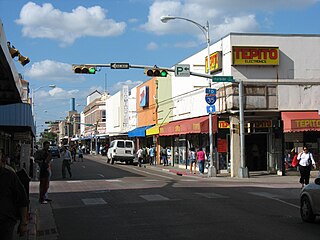
Downtown Laredo is the second main business district in Laredo, Texas. Downtown Laredo is the starting point for Interstate Highway 35 and State Highway 359. It is home to all of Laredo's high-rise buildings. Laredo's and Webb County's main government buildings are located in Downtown Laredo. Most of Webb County's National Register of Historic Places are in this area.
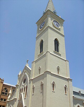
The San Agustin de Laredo Historic District is a historical district that covers what was once the original city of Laredo, Texas that was established by Don Tomás Sánchez. Today, the district is located in Downtown Laredo. The San Agustin District is home to San Agustin Cathedral and to the Republic of the Rio Grande Capitol. Most of the district's streets are made from bricks. Most of the buildings in the district reflect Spanish and Mexican influences and are made from masonry. The district is considered the last example of Spanish Colonization of the Lower Rio Grande Valley. The San Agustin de Laredo Historic District is registered in the National Register of Historic Places since 1973. Its historic significance is Architecture and Engineering. Its architectural style is Mission, Spanish Revival, and Greek Revival.

Zacate Creek is inside Laredo, Texas city limits and runs southwest for 10 miles (16 km) until it connects to the Rio Grande. Zacate Creek has several ditches leading to it. The terrain surrounding the creek is mostly clay. The vegetation surrounding the creek is mostly made up of mesquite, cacti, and grasses. Zacate Creek and branches cross several highways in Laredo, Texas among them are: Interstate 35, United States Route 59, Texas State Highway Spur 400, Texas State Highway 359, and United States Route 83. The northern branch of the Zacate Creek has a small dam which formed a pond located in Northeast Laredo which is usually filled during storms. The city of Laredo has developed the Zacate Creek Park and the Zacate Creek Greenway, a three mile (4.8 km) trail near the creek.
The Battle of Laredo was fought during the American Civil War. Laredo, Texas was a main route to export cotton to Mexico on behalf of the Confederate States amid the Union blockade of ports along the Gulf of Mexico. On March 18, 1864, Major Alfred F. Holt led a Union force from Brownsville, Texas, to destroy 5,000 bales of cotton stacked at the San Agustín Plaza. Colonel Santos Benavides commanded 42 Confederate soldiers and repelled three Union attacks at Zacate Creek. Colonel Santos Benavides secured passage of the 5,000 cotton bales into Mexico.
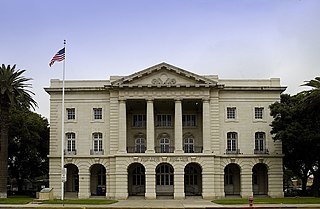
The U.S. Post Office and Courthouse is a historic government building located in Laredo in Webb County, Texas. It previously served as a custom house and a courthouse for the United States District Court for the Southern District of Texas. It continues to serve as a post office.

Interstate 69W (I-69W) is a relatively short north–south Interstate Highway running through South Texas in the United States. The freeway begins northeast of the middle of the World Trade International Bridge in Laredo and ends at I-35. In the future, I-69W will head northeast for 180 miles (290 km) before terminating near Victoria as both I-69E and I-69W merge to form I-69. For its entire length, I-69W runs concurrently with U.S. Highway 59 (US 59).
The following is a timeline of the history of the city of Laredo, Texas, USA.