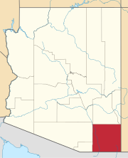
Lowell is a populated place situated in Cochise County, Arizona. It was incorporated into Bisbee in the early 1900s. Lowell has an estimated elevation of 5,075 feet (1,547 m) above sea level.

Bisbee Junction is a populated place situated in Cochise County, Arizona. It has an estimated elevation of 4,688 feet (1,429 m) above sea level.

Calumet is a populated place situated in Cochise County, Arizona. It has an estimated elevation of 3,970 feet (1,210 m) above sea level.

Curtiss is a populated place situated in Cochise County, Arizona. It has an estimated elevation of 3,622 feet (1,104 m) above sea level.

Corta Junction is a populated place situated in Cochise County, Arizona. It has an estimated elevation of 4,908 feet (1,496 m) above sea level.

Fenner is a populated place situated in Cochise County, Arizona. It has an estimated elevation of 3,711 feet (1,131 m) above sea level.

Forrest is a populated place situated in Cochise County, Arizona. It has an estimated elevation of 4,196 feet (1,279 m) above sea level.

Galeyville is a populated place situated in Cochise County, Arizona. It has an estimated elevation of 5,732 feet (1,747 m) above sea level.

Luzena, also known as Bowie Junction, is a populated place situated in Cochise County, Arizona. It has an estimated elevation of 4,019 feet (1,225 m) above sea level.

Manzoro is a populated place situated in Cochise County, Arizona. It has an estimated elevation of 4,439 feet (1,353 m) above sea level.

Ramsey is a populated place situated in Cochise County, Arizona, slightly north of the international boundary with Mexico. It has an estimated elevation of 5,659 feet (1,725 m) above sea level.

Rileys El Encinar is a populated place situated in Cochise County, Arizona. It has an estimated elevation of 5,036 feet (1,535 m) above sea level.

South Bisbee is a populated place situated in Cochise County, Arizona, just north of the international border with Mexico. It has an estimated elevation of 5,207 feet (1,587 m) above sea level.

Stark is a populated place situated in Cochise County, Arizona, right along the international border with Mexico. It has an estimated elevation of 4,393 feet (1,339 m) above sea level.

Sunnyside is a populated place situated in the far west of Cochise County, Arizona, just north of the international border with Mexico. It has an estimated elevation of 5,814 feet (1,772 m) above sea level.

Taylor Place is a populated place situated in Cochise County, Arizona. It has an estimated elevation of 5,518 feet (1,682 m) above sea level.

Tully is a populated place in Cochise County, Arizona. It has an estimated elevation of 4,334 feet (1,321 m) above sea level.

Vanar is a populated place situated in Cochise County, Arizona, right against the border with New Mexico. It has an estimated elevation of 3,917 feet (1,194 m) above sea level.

Wheeler Place is a populated place situated in Cochise County, Arizona. It has an estimated elevation of 4,094 feet (1,248 m) above sea level.

Yellow Hammer Mill is a populated place situated in Cochise County, Arizona. It has an estimated elevation of 3,504 feet (1,068 m) above sea level.


