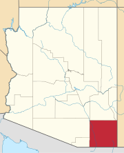
Paul Spur, Arizona

Last updated
Paul Spur, Arizona
Populated place
USA Arizona location map.svg
Red pog.svg
Paul Spur
Location within the state of Arizona
Usa edcp location map.svg
Red pog.svg
Paul Spur
Paul Spur (the US)
Coordinates: 31°21′58″N109°44′04″W / 31.36611°N 109.73444°W / 31.36611; -109.73444 Coordinates: 31°21′58″N109°44′04″W / 31.36611°N 109.73444°W / 31.36611; -109.73444
Country United States
State Arizona
County Cochise
Elevation [1] 4,222 ft (1,287 m)
Time zone Mountain (MST) (UTC-7)
  Summer (DST) MST (UTC-7)
Area code(s) 520
FIPS code 04-53630
GNIS feature ID 9264

Paul Spur is a populated place situated along in the international border with Mexico in Cochise County, Arizona. [2] It has an estimated elevation of 4,222 feet (1,287 m) above sea level. [1]

Unincorporated area Region of land not governed by own local government

In law, an unincorporated area is a region of land that is not governed by a local municipal corporation; similarly an unincorporated community is a settlement that is not governed by its own local municipal corporation, but rather is administered as part of larger administrative divisions, such as a township, parish, borough, county, city, canton, state, province or country. Occasionally, municipalities dissolve or disincorporate, which may happen if they become fiscally insolvent, and services become the responsibility of a higher administration. Widespread unincorporated communities and areas are a distinguishing feature of the United States and Canada. In most other countries of the world, there are either no unincorporated areas at all, or these are very rare; typically remote, outlying, sparsely populated or uninhabited areas.

Mexico Country in the southern portion of North America

Mexico, officially the United Mexican States, is a country in the southern portion of North America. It is bordered to the north by the United States; to the south and west by the Pacific Ocean; to the southeast by Guatemala, Belize, and the Caribbean Sea; and to the east by the Gulf of Mexico. Covering almost 2,000,000 square kilometres (770,000 sq mi), the nation is the fifth largest country in the Americas by total area and the 13th largest independent state in the world. With an estimated population of over 120 million people, the country is the tenth most populous state and the most populous Spanish-speaking state in the world, while being the second most populous nation in Latin America after Brazil. Mexico is a federation comprising 31 states and Mexico City, a special federal entity that is also the capital city and its most populous city. Other metropolises in the state include Guadalajara, Monterrey, Puebla, Toluca, Tijuana and León.

Related Research Articles

Lowell, Arizona Populated place in Arizona, United States

Lowell is a populated place situated in Cochise County, Arizona. It was incorporated into Bisbee in the early 1900s. Lowell has an estimated elevation of 5,075 feet (1,547 m) above sea level.

Apache Flats, Arizona Populated place in Arizona, United States

Apache Flats is a populated place situated with the city of Sierra Vista in Cochise County, Arizona. It has an estimated elevation of 4,951 feet (1,509 m) above sea level.

Black Bear Spring, Arizona Populated place in Arizona, United States

Black Bear Spring is a populated place situated in Cochise County, Arizona. It has an estimated elevation of 7,569 feet (2,307 m) above sea level.

Black Diamond, Arizona Populated place in Arizona, United States

Black Diamond is a populated place situated in Cochise County, Arizona. It has an estimated elevation of 5,138 feet (1,566 m) above sea level.

Bledsoe, Arizona Populated place in Arizona, United States

Bledsoe is a populated place situated in Cochise County, Arizona. It has an estimated elevation of 5,545 feet (1,690 m) above sea level.

Bradberry, Arizona Populated place in Arizona, United States

Bradberry is a populated place situated in Cochise County, Arizona. It has an estimated elevation of 4,035 feet (1,230 m) above sea level.

Calumet, Arizona Populated place in Arizona, United States

Calumet is a populated place situated in Cochise County, Arizona. It has an estimated elevation of 3,970 feet (1,210 m) above sea level.

Chamiso, Arizona Populated place in Arizona, United States

Chamiso is a populated place situated in Cochise County, Arizona, United States. It has an estimated elevation of 3,845 feet (1,172 m) above sea level.

Double Adobe, Arizona Populated place in Arizona, United States

Double Adobe is a populated place situated in Cochise County, Arizona. It has an estimated elevation of 4,009 feet (1,222 m) above sea level.

Fenner, Arizona Populated place in Arizona, United States

Fenner is a populated place situated in Cochise County, Arizona. It has an estimated elevation of 3,711 feet (1,131 m) above sea level.

Forrest, Arizona Populated place in Arizona, United States

Forrest is a populated place situated in Cochise County, Arizona. It has an estimated elevation of 4,196 feet (1,279 m) above sea level.

Galeyville, Arizona Populated place in Arizona, United States

Galeyville is a populated place situated in Cochise County, Arizona. It has an estimated elevation of 5,732 feet (1,747 m) above sea level.

Grizzles Orchard, Arizona Populated Place in Arizona, United States

Grizzles Orchard is a populated place situated in Cochise County, Arizona. It has an estimated elevation of 4,301 feet (1,311 m) above sea level.

Highland Park, Cochise County, Arizona Populated place in Arizona, United States

Highland Park is a populated place situated in Cochise County, Arizona. It has an estimated elevation of 5,800 feet (1,800 m) above sea level.

Hilltop, Arizona Populated place in Arizona, United States

Hilltop is a populated place situated in Cochise County, Arizona. It has an estimated elevation of 5,702 feet (1,738 m) above sea level.

Manzoro, Arizona Populated place in Arizona, United States

Manzoro is a populated place situated in Cochise County, Arizona. It has an estimated elevation of 4,439 feet (1,353 m) above sea level.

Stark, Arizona Populated place in Arizona, United States

Stark is a populated place situated in Cochise County, Arizona, right along the international border with Mexico. It has an estimated elevation of 4,393 feet (1,339 m) above sea level.

Taylor Place, Arizona Populated place in Arizona, United States

Taylor Place is a populated place situated in Cochise County, Arizona. It has an estimated elevation of 5,518 feet (1,682 m) above sea level.

Vanar, Arizona Populated place in Arizona, United States

Vanar is a populated place situated in Cochise County, Arizona, right against the border with New Mexico. It has an estimated elevation of 3,917 feet (1,194 m) above sea level.

Wheeler Place, Arizona Populated place in Arizona, United States

Wheeler Place is a populated place situated in Cochise County, Arizona. It has an estimated elevation of 4,094 feet (1,248 m) above sea level.

References