Bents

Last updated

Bents
Bents Elevator.jpg
Bents grain elevator.
Canada Saskatchewan location map.svg
Red pog.svg
Bents
Coordinates: 51°48′58″N107°44′02″W / 51.816°N 107.734°W / 51.816; -107.734
Country Canada
Province Saskatchewan
Region Southwest Saskatchewan
Census division 12
Rural Municipality Marriott
Established1905
Incorporated (Village)N/A
Government
  AdministratorMichelle McQueen
  Governing body Marriott No. 317
Time zone CST
Postal code
S0L 2V0
Area code 306
Highways Range Road 131
Waterways The Coteau
[1] [2] [3] [4]

Bents is an unincorporated community in Marriott No. 317, Saskatchewan, Canada. Prior to the town founding, the area was referred to as Piche. Bents took its name from Longniddry Bents in Scotland. Its derelict wooden grain elevator was once the subject of a National Geographic photograph. [5] The remnants of the town are now located on private property. [6]

Contents

History

Bents was officially established in 1930 along a CPR rail line that ran between Perdue and Rosetown. [7] The railway came through the area in 1929 and at one point Bents boasted several residential homes, a small train station, two grain elevators, a dance hall, a general store (Longworth’s General Store) and post office - all along a single street. By the 1960s the town began an irreversible decline when the southern section of the rail line was abandoned. The general store, above which lived the proprietor's family, was in business until the early 1960s. The railway continued to run through Bents until the 1970s when it too was torn up around 1977. It was at this time that the Saskatchewan Wheat Pool elevator, built in 1928 with the coming of the railway, closed for good. The United Grain Growers elevator, also built in 1928, was sold to the Wheat Pool in the late 1960s and was also closed and torn down in the 1970s. [8]

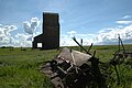
Today, little remains. Only one of the two elevators, the Saskatchewan Wheat Pool elevator, still stands. There are two houses left. One, belonged to a huge family and the other belonged to an auctioneer. The general store/post-office is still there but in badly deteriorated condition. There are random outbuildings and old farm machinery dotting the former town site. There is also a metal swing-set, missing the swings, sitting alone in the grass beside the general store. The former town site is now private property and has been the subject of vandalism over the years. Any visits to Bents must be arranged with the landowner. [9]

See also

Related Research Articles

<span class="mw-page-title-main">Grain elevator</span> Grain storage building

A grain elevator is a facility designed to stockpile or store grain. In the grain trade, the term "grain elevator" also describes a tower containing a bucket elevator or a pneumatic conveyor, which scoops up grain from a lower level and deposits it in a silo or other storage facility.

Coleville is a village in the Canadian province of Saskatchewan within the Rural Municipality of Oakdale No. 320 and Census Division No. 13. The village's main economic factors are oil and farming, namesake of the Coleville oilfields. The village is named for Malcolm Cole who became the community's first postmaster in 1908.

<span class="mw-page-title-main">Sintaluta</span> Town in Saskatchewan, Canada

Sintaluta is a small town in Saskatchewan, Canada. The current population of Sintaluta is approximately 119 people according to the 2016 Canadian Census. The town is located about 85 km east of Regina. The town is located on the north side of the Trans-Canada Highway.

<span class="mw-page-title-main">Hepburn, Saskatchewan</span> Town in Saskatchewan, Canada

Hepburn is a town in Saskatchewan, Canada, approximately 45 kilometres north of Saskatoon.

Rockglen is a town in the Burning Hills of the Wood Mountain Uplands, in Saskatchewan, Canada, providing a school, community hall, public library and five parks, as well a local service industry. The municipal office of Rural Municipality of Poplar Valley No. 12 lies within the boundaries of Rockglen, and Rockglen businesses are supported primarily by agriculture. In the Burning Hills agriculture consists of dry land farming and cattle. Rockglen is located along Highway 2 south of Assiniboia, Highway 18 west of Coronach, and Highways 2 and 18 north of Port Poplar River. Fife Lake is 9.3 kilometres (5.8 mi) to the east.

<span class="mw-page-title-main">Saskatchewan Wheat Pool</span> Canadian grain handling company

The Saskatchewan Wheat Pool was a grain handling, agri-food processing and marketing company based in Regina, Saskatchewan. The Pool created a network of marketing alliances in North America and internationally which made it the largest agricultural grain handling operation in the province of Saskatchewan. Before becoming Viterra, SWP had operated 276 retail outlets and more than 100 grain handling and marketing centres. The Saskatchewan Wheat Pool operated under the name of AgPro in the prairie provinces of Manitoba and Alberta. Begun as a co-operative in the 1920s, the company became a publicly traded corporation in the 1990s. After the 2007 takeover of its competitor, Winnipeg-based Agricore United, the Pool name was retired. The merged company operated under the name Viterra until 2013, when it was acquired by Glencore International.

Love is a village in the Canadian province of Saskatchewan within the Rural Municipality of Torch River No. 488 and Census Division No. 14. The village is northeast of the City of Prince Albert and about 48 km (30 mi) south of Prince Albert National Park boundaries and 16 km (9.9 mi) south of Torch River Provincial Forest.

<span class="mw-page-title-main">Robsart, Saskatchewan</span> Unincorporated hamlet in Saskatchewan, Canada

Robsart is an unincorporated hamlet within the rural municipality of Reno No. 51, in the province of Saskatchewan, Canada. Robsart had a population of 20 at the 2016 Canada Census. Robsart previously incorporated an independent village since 1912 until it was dissolved into an unincorporated community on January 1, 2002 under the jurisdiction of the rural municipality of Reno No. 51. Robsart is located 48 km southwest of the town of Eastend at the junction of Highway 18 and Highway 13 approximately 170 km south-east of Medicine Hat, Alberta, 68 km south of the Town of Maple Creek.

<span class="mw-page-title-main">Crichton, Saskatchewan</span> Unincorporated community in Saskatchewan, Canada

Crichton is an unincorporated community within the Rural Municipality of Wise Creek No. 77, Saskatchewan, Canada. It is located between Admiral and Cadillac on the historic Red Coat Trail, also known as Highway 13. Like so many towns along the Red Coat Trail, Crichton has become a ghost town with only one family remaining and many empty buildings scattered throughout the town site.

<span class="mw-page-title-main">Vidora</span> Unincorporated community in Saskatchewan, Canada

Vidora is an unincorporated community within the Rural Municipality of Reno No. 51, Saskatchewan, Canada. The community once had a population of 200 people in 1940 and has since declined to 1 resident. It previously held village status until it was dissolved as an unincorporated community on January 1, 1952. The community is located between Robsart and Consul on highway 21 & highway 13 known as the Red Coat Trail. Very little remains of the former village, only one home that is also used as a post office still stands as of 2008. There are many cement foundations and sidewalks still found scattered around the town site, including the remnants of the old bank vault to the former Municipality Office that was moved to Consul.

<span class="mw-page-title-main">Neidpath, Saskatchewan</span> Hamlet in Saskatchewan, Canada

Neidpath, is a hamlet in Coulee Rural Municipality No. 136, Saskatchewan, Canada. The hamlet is located on Highway 363 and Highway 720 about 25 km east of the city of Swift Current.

Herschel is a special service area in the Canadian province of Saskatchewan. It is the seat of the Rural Municipality of Mountain View No. 318 and held village status prior to December 31, 2006. The population was 30 people in 2016. The community is located 37 km northwest of the town of Rosetown at the intersection of Highway 31 and Highway 656, along a now abandoned section of the Kerrobert-Rosetown Canadian Pacific Railway line. Herschel is the home of the Ancient Echoes Interpretive Centre. The Vancouver-based backpack manufacturer Herschel Supply Co., founded by Lyndon and Jamie Cormack in 2009, adopted the name of Herschel, the town where three generations of their family grew up.

<span class="mw-page-title-main">Clair, Saskatchewan</span> Unincorporated community in Saskatchewan, Canada

Clair is a community in Saskatchewan, Canada located north of the provincial capital city of Regina, Saskatchewan. It is also 116.26 miles (187.10 km) east of Saskatoon. Prince Albert is 132.68 miles (213.53 km) north west of Clair and Yorkton is 101.93 miles (164.04 km) south east of Clair. It is on Saskatchewan Highway 5. Clair is located in the Saskatchewan prairies.

Anerley is an unincorporated community in the western region of Saskatchewan located about 4 km north of Highway 44, about 20 km southwest of the Outlook and is about 125 km south west of Saskatoon.

Ruthilda is a former village in the Rural Municipality of Grandview No. 349, Saskatchewan, Canada. It dissolved from village status to become part of the Rural Municipality of Grandview No. 349 on December 31, 2013. Ruthilda is located about 5 km south of Highway 51 approximately 30 km southwest of the Town of Biggar.

<span class="mw-page-title-main">Rural Municipality of Bengough No. 40</span> Rural Municipality in Saskatchewan, Canada

The Rural Municipality of Bengough No. 40 is a rural municipality (RM) in the Canadian province of Saskatchewan within Census Division No. 2 and SARM Division No. 2. It is located in the southeast portion of the province.

<span class="mw-page-title-main">Sharples, Alberta</span>

Sharples is a ghost town in southern Alberta, Canada within the badlands region of Kneehill County. The community is located along the former track bed of the Canadian Pacific Railway, Carbon-Drumheller branch line. It was built in the 1920s when the CPR line was extended through the area.

Elswick is a ghost town in Cymri Rural Municipality, Saskatchewan, Canada. The town site was on the Canadian Northern Railway line from Lampman to Radville. The town had a box-car train station, grain elevator, small store and post office. The town site was abandoned by the railway in 1927 and the rail-line abandoned in 1951.

<span class="mw-page-title-main">Horizon, Saskatchewan</span> Unincorporated Community in Saskatchewan, Canada

Horizon, located on the south side of Channel Lake, is a hamlet in Bengough Rural Municipality No. 40, Saskatchewan, Canada. It previously held the status of village until December 31, 1973. The hamlet is located 60 km (37 mi) east of the Town of Assiniboia on highway 13.

References

  1. National Archives, Archivia Net, Post Offices and Postmasters, archived from the original on 2006-10-06
  2. Government of Saskatchewan, MRD Home, Municipal Directory System, archived from the original on November 21, 2008
  3. Canadian Textiles Institute. (2005), CTI Determine your provincial constituency, archived from the original on 2007-09-11
  4. Commissioner of Canada Elections, Chief Electoral Officer of Canada (2005), Elections Canada On-line, archived from the original on 2007-04-21
  5. Ryan, Pete. "Picture Id: 1467727". National Geographic Image Collection . National Geographic Society . Retrieved 2017-04-04.
  6. "Bents,Saskatchewan". 2015-08-04. Retrieved 2017-08-01.
  7. "Saskatchewan Abandoned Rail Lines" (PDF).
  8. ChrisBIGDoer (4 August 2015). "Bents". Off The Beaten Path - with Chris & Connie. Retrieved 2019-04-08.
  9. "Bents, Saskatchewan". jordanmiller.ca. 2016-03-25. Retrieved 2019-04-08.

Coordinates: 51°48′58″N107°44′02″W / 51.816°N 107.734°W / 51.816; -107.734