Booth, Texas

Last updated

Booth, Texas
Booth Texas Historic Marker.JPG
Historical marker in Booth
Relief map of Texas.png
Red pog.svg
Booth
Usa edcp relief location map.png
Red pog.svg
Booth
Coordinates: 29°31′48″N95°39′00″W / 29.53000°N 95.65000°W / 29.53000; -95.65000
Country United States
State Texas
County Fort Bend
Elevation
74 ft (23 m)
Time zone UTC-6 (Central (CST))
  Summer (DST) UTC-5 (CDT)
ZIP code
77469
Area code 281

Booth is a small unincorporated community in Fort Bend County, Texas, United States. It is located along Farm to Market Road 2759 and the BNSF Railway southeast of Richmond, Texas. There are number of houses, an RV-park, a restaurant, a landscaping business and a historical marker in the area.

Contents

Geography

The BNSF Railway tracks run parallel to and south of FM 2759 through the area. Both railroad and highway come into Booth from the west-northwest. They curve slightly and leave Booth heading southeast. An historical marker is at the corner of FM 2759 and Agnes Road. The Old Trading Post restaurant is nearby. Agnes Road continues north-northeast 0.8 miles (1.3 km) to the Riverbend RV Park; beyond that point it becomes a one-lane trail and dead ends before reaching the Brazos River. The Enchanted Forest nursery is located 0.6 miles (1.0 km) southeast on FM 2759 at Insurance Road. The Royal Lakes subdivision entrance is 1.0 mile (1.6 km) to the west-northwest on the south side of the railroad tracks. Velasquez Elementary School is 2.2 miles (3.5 km) west-northwest on FM 2759 at Macek Road. [1]

History

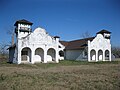
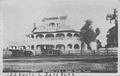
The property on which today's community stands was granted to Henry Jones (1789-1861) in Stephen F. Austin's Texas colony. Freeman Irby Booth, a wealthy landowner who owned a cotton gin, general store, lumberyard and syrup mill, founded the settlement in the 1890s. The community received a post office in 1894. Two years later there was a school, Baptist church and 150 residents. By 1914, a population of about 300 was served by a bank and telephone connections. The community's segregated schools taught 85 white and 177 black students in 1926. From the mid-1920s through 1948, about 100 people lived in the settlement. During the 1940s Booth had a school and two churches but by the end of the decade there were only 40 persons living there. In the 1980s there were two businesses and by 1990 there were about 60 residents. [2]

Government and infrastructure

Fort Bend County does not have a hospital district. OakBend Medical Center serves as the county's charity hospital which the county contracts with. [3]

Education

Booth is zoned to schools in the Lamar Consolidated Independent School District. The schools include William C. Velazquez Elementary School, Reading Junior High School and George Ranch High School. [4]

Related Research Articles

<span class="mw-page-title-main">Wallis, Texas</span> City in Texas, United States

Wallis is a city in far southeastern Austin County, Texas, United States. The city is located along State Highway 36 (SH 36) and the BNSF Railway between Rosenberg and Sealy. The city's population was 1,292 at the 2020 census.

<span class="mw-page-title-main">Fresno, Texas</span> Census-designated place in Texas, United States

Fresno is an unincorporated community and census-designated place (CDP) in Fort Bend County, Texas, United States. The local population was 24,486 as of the 2020 census, up from 19,069 at the 2010 census, and 6,603 at the 2000 census.

<span class="mw-page-title-main">Kendleton, Texas</span> City in Texas, United States

Kendleton is a city in western Fort Bend County, Texas southwest of Sugar Land, Texas. It was established by emancipated slaves after the American Civil War. The population was 380 at the 2010 census, down from 466 at the 2000 census. As of 2011, Darryl Humphrey was the mayor of the city.

<span class="mw-page-title-main">Needville, Texas</span> City in Texas, United States

Needville is a city in Fort Bend County, Texas, United States. It is within the Houston–Sugar Land metropolitan area. The population was 3,089 at the 2020 census.

<span class="mw-page-title-main">Orchard, Texas</span> City in Texas, United States

Orchard is a city in western Fort Bend County, Texas, United States, within the Houston–Sugar Land–Baytown metropolitan area. The community is located along State Highway 36 (SH 36) and the BNSF Railway between Rosenberg in Fort Bend County and Wallis in Austin County. The population was 352 at the 2010 census, down from 408 at the 2000 census.

<span class="mw-page-title-main">Thompsons, Texas</span> Town in Texas, United States

Thompsons is a town in Fort Bend County, Texas, United States, within the Houston–Sugar Land–Baytown metropolitan area. The population was 246 at the 2010 census.

<span class="mw-page-title-main">Juliff, Texas</span> Unincorporated community in Texas, United States

Juliff is an unincorporated community situated along Farm to Market Road 521 (FM 521) in eastern Fort Bend County, Texas, United States. The settlement was founded in the 1850s as a shipping point along the Brazos River and the railroad reached there in the same decade. The community received postal service in 1891, and except for a brief closure, retained it until the late 1950s. Starting in the 1930s, Juliff enjoyed a heyday as a place of raucous entertainment after local residents opened several taverns and dance halls. This era ended in the 1960s when the bars relocated to Houston. Sometime later, the railroad that ran alongside FM 521 was discontinued. In December 2013 the community was a collection of homes along the east side of FM 521.

DeWalt or Dewalt was an unincorporated area in Fort Bend County, in the U.S. state of Texas. The former community was located on State Highway 6 between Oilfield Road and Farm to Market Road 1092 (FM 1092). DeWalt has been absorbed by the municipality of Missouri City, a Houston suburb. Though Dewalt was noted on highway signs as late as 2013, there are few surviving structures and locations from the original community. In 2006, the Dew Plantation's house was moved from DeWalt to nearby Kitty Hollow Park to preserve it as a museum. The private Dewalt Cemetery still exists within the Lake Olympia subdivision.

<span class="mw-page-title-main">Crabb, Texas</span> Unincorporated community in Texas, United States

Crabb is a small unincorporated community in Fort Bend County, Texas, United States. Crabb is located along Farm to Market Road 762 and the BNSF Railroad southeast of Richmond, Texas. The Crabb road sign is located west of the intersection of Crabb River Road and Farm to Market Road 2759 and FM 762. The Zion Hill Baptist Church, a Fort Bend County Road and Bridge facility, the Brazos Village and Brazos Gardens subdivisions, several businesses and an abandoned grain elevator are in the area.

<span class="mw-page-title-main">Guy, Texas</span> Unincorporated community in Texas, United States

Guy is an unincorporated community in Fort Bend County, Texas, United States. It is located on Texas State Highway 36 (SH 36) about 16 miles (26 km) south of Rosenberg, Texas. A trucking company, a Shell Oil Company filling station, a post office, and several homes are located near the intersection of SH 36 and Farm to Market Road 1994 (FM 1994). The community was established in 1890 and was served by a railroad between 1918 and the 1980s.

<span class="mw-page-title-main">Long Point, Texas</span> Ghost town in Texas, United States

Long Point is a ghost town in Fort Bend County, Texas, United States. It is located 24 miles (39 km) southeast of Richmond, Texas at the intersection of Farm to Market Road 1994 and FM 361. There is no road sign identifying the community, though the nearby roads carry its name. Petroleum and sulphur were extracted near the community in the 1930s. Electric transmission towers pass through the site and a county landfill is located to the northeast.

<span class="mw-page-title-main">Foster, Fort Bend County, Texas</span> Unincorporated community in Texas, United States

Foster exists in memory as a pioneer Texas community that is located in Fort Bend County, Texas, United States along Farm to Market Road 359, beginning approximately 1.0 mile (1.6 km) northwest of its intersection with Farm to Market Road 723. It is considered by local homeowners to be an unincorporated community.

<span class="mw-page-title-main">Tavener, Texas</span> Unincorporated community^^ in Texas, United States

Tavener is an unincorporated community in Fort Bend County, Texas, United States. It is located 4 miles (6.4 km) east-northeast of East Bernard, Texas, near the intersection of U.S. Highway 90 Alternate and Farm to Market Road 1952. Tavener no longer has its own post office, schools and railroad stop, as it once did. There is no road sign identifying the community though the Tavener Gin is prominently labeled on the north side of the Union Pacific railway line, which parallels US 90A. A small bar and grill and a number of homes can be found in the area.

<span class="mw-page-title-main">Powell Point, Texas</span>

Powell Point is an Unincorporated community in Fort Bend County, Texas, United States.

<span class="mw-page-title-main">Farm to Market Road 359</span> State highway in the state of Texas

Farm to Market Road 359 (FM 359) is a state highway in the U.S. state of Texas. The highway begins at U.S. Route 90 Alternate near Richmond in Fort Bend County. FM 359 heads in a northwesterly direction through Pecan Grove and Fulshear to Interstate 10 at Brookshire in Waller County. Continuing to the northwest, the highway passes through the small communities of Pattison, Monaville and Pine Island before ending at U.S. Route 290 (US 290) and Texas Highway 6 (SH 6) east of Hempstead.

<span class="mw-page-title-main">Farm to Market Road 1952</span>

Farm to Market Road 1952 (FM 1952) is a state highway in the U.S. state of Texas. The highway begins at U.S. Route 90 Alternate at Tavener in Fort Bend County and goes north, then west, then north again to State Highway 36 (SH 36) at Wallis in Austin County. The two-lane highway is also named Tavener Road.

Phillipsburg is an unincorporated community in south Washington County, in the U.S. state of Texas. The very small rural community is located along State Highway 36 (SH 36) south of Brenham. Aside from the names of two local roads, the name Phillipsburg is no longer marked on modern maps. The cemetery and Lutheran church, which is still open for worship, are actually slightly to the south in neighboring Austin County.

References

  1. Google (January 7, 2013). "Booth, Texas" (Map). Google Maps . Google. Retrieved January 7, 2013.
  2. Odintz, Mark. "Handbook of Texas Online: BOOTH, TX". Texas State Historical Association. Retrieved January 7, 2013.
  3. Knipp, Bethany (November 2, 2016). "Fort Bend County lacks hospital district". Community Impact Newspaper . Retrieved October 18, 2021.
  4. "District Map". Lamar Consolidated Independent School District. Archived from the original on September 24, 2012. Retrieved January 7, 2013.