Border irregularities of Canada

Last updated

There are multiple border irregularities in Canada. Often, they are a result of borders which do not conform to geological features such as changes in the course of a river that previously marked a border.

Contents

Salients

Map of Southern Ontario Canada Southern Ontario location map 2.png
Map of Southern Ontario

A salient, panhandle, or bootheel is an elongated protrusion of a geopolitical entity, such as a subnational entity or a sovereign state.

Enclaves and Exclaves

An enclave is a piece of land belonging to one country (or region etc.) that is totally surrounded by another country (or region). An exclave is a piece of land that is politically attached to a larger piece but not physically contiguous with it (connected to it) because they are completely separated by a surrounding foreign territory or territories.

Enclaves

Location of the Caniapiscu Regional County Municipality Quebec MRC Caniapiscau location map.svg
Location of the Caniapiscu Regional County Municipality

Exclaves

Semi-enclaves

Campobello Island Campobello Island lighthouse.jpg
Campobello Island
Tungsten, Northwest Territories Tungsten, Northwest Territories.jpg
Tungsten, Northwest Territories

Pene enclaves/exclaves

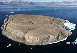
Hans Island HansIsland.png
Hans Island

Divided islands

Split settlements

References

  1. "Census of Population". Statistics Canada. January 15, 2001. Retrieved September 1, 2025.
  2. Peter, Jan; Scott, Steven. "Windy Craggy, Northwestern British Columbia: The World's Largest Besshi-Type Deposit" (PDF). Government of British Columbia . Retrieved September 7, 2025.
  3. "Atlin, BC - Yukon Territory Information". Yukon Info. Retrieved September 8, 2025.
  4. "Nunavut". Indigenous Peoples Atlas of Canada. Retrieved September 8, 2025.
  5. Jacobs, Frank (June 14, 2022). "On tiny Hans Island, Denmark and Canada create world's newest land border". Big Think. Retrieved September 6, 2025.
  6. "Chapter 5: The 49th Parallel". A Linear Portrait of the USA/Canada Border. The Center for Land Use Interpretation. Retrieved September 6, 2025.
  7. "Pine and Curry Island Scientific and Natural Area" (PDF). Minnesota Department of Natural Resources . January 1986. Retrieved September 5, 2025.
  8. Francis, Daniel (February 7, 2006). "Killiniq Island". The Canadian Encyclopaedia. Retrieved September 8, 2025.
  9. Kulchyski, Peter (August 11, 2017). "The Creation of Nunavut". Canadas History. Retrieved September 7, 2025.
  10. Forests and clearings: the history of Stanstead County, province of Quebec, with sketches of more than five hundred families, by Hubbard, B. F. (Benjamin F.), b. 1798; Lawrence, John, b. 1814, Published 1874
  11. McCabe, Peter; Paperny, Anna Mehler; Paperny, Anna Mehler (March 21, 2025). "US government blocks Canadian access to border-straddling library". Reuters . Retrieved September 8, 2025.
  12. Canfield, Clarke (February 16, 2003). "Casual Border Crossing Throws a Life in Limbo". Los Angeles Times . Retrieved September 8, 2025.
  13. Rennie, Sarah; Reporter, L. J. I.; Reporter, Sarah Rennie-LJI (March 26, 2025). "Business as usual at the Halfway House in Dundee - The Gleaner" . Retrieved September 8, 2025.
  14. Keating, Joshua (July 1, 2018). "The Nation That Sits Astride the U.S.-Canada Border". POLITICO Magazine. Retrieved September 8, 2025.
  15. Tweed, Charles (June 4, 2016). "Jun 2016: Lake Metigoshe boaters take issue with customs changes". Brandon Sun. Retrieved September 8, 2025.
  16. Herperger, Don (September 20, 2012). "Lloydminster". The Canadian Encyclopaedia. Retrieved September 8, 2025.