
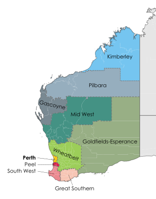
The Wheatbelt is one of nine regions of Western Australia defined as administrative areas for the state's regional development, and a vernacular term for the area converted to agriculture during colonisation. It partially surrounds the Perth metropolitan area, extending north from Perth to the Mid West region, and east to the Goldfields–Esperance region. It is bordered to the south by the South West and Great Southern regions, and to the west by the Indian Ocean, the Perth metropolitan area, and the Peel region. Altogether, it has an area of 154,862 square kilometres (59,793 sq mi).

The Shire of Beverley is a local government area in the Wheatbelt region of Western Australia about 130 kilometres (80 mi) southeast of Perth, the state capital. The Shire covers an area of 2,372 square kilometres (916 sq mi), starting 20 kilometres (12 mi) outside Armadale in the Darling Scarp and extending eastwards beyond the scarp into agricultural lands which support broad acre activities such as livestock and cropping. Its seat of government is the town of Beverley, which accommodates just over half of the Shire's population.

The Shire of Brookton is a local government area in the Wheatbelt region of Western Australia, about 140 kilometres (87 mi) southeast of Perth, the state capital. The Shire covers an area of 1,602 square kilometres (619 sq mi) and its seat of government is the town of Brookton.

The Shire of Pingelly is a local government area in the Wheatbelt region of Western Australia, about 160 kilometres (99 mi) southeast of the state capital, Perth, between the Shires of Brookton and Cuballing along the Great Southern Highway. The Shire covers an area of 1,295 square kilometres (500 sq mi), and its seat of government is the town of Pingelly.

The Shire of Corrigin is a local government area in the Wheatbelt region of Western Australia, about 230 kilometres (143 mi) east of the state capital, Perth. Its seat of government is the town of Corrigin. The shire covers an area of 3,095 square kilometres (1,195 sq mi) and the economy, worth approximately $50 million per year to the state economy, is based on agriculture - predominantly cereal grains and sheep, with some supporting industries including a flour mill.

The Ongerup branch railway, also known as the Tambellup, Gnowangerup to Ongerup railway is a former railway line in the Great Southern region of Western Australia.

The Pinjarra to Narrogin railway was a 153 kilometre cross-country railway line built between the towns of Pinjarra and Narrogin in Western Australia.

The Mullewa–Meekatharra railway was a section of the Northern Railway in Western Australia.

Boyagin Rock is located 10 km (6.2 mi) south west of Brookton and 26 km (16 mi) north west of Pingelly in the Wheatbelt region of Western Australia, which is approximately 175 km (109 mi) south east of Perth. The Boyagin Rock outcrop rises 50 m (160 ft) above the surrounding land and is an crestal area of a granite inselberg within the geological Yilgarn Craton framework.
This is a list of newspapers published in, or for, the Wheatbelt region of Western Australia.

The Merredin to Narrogin railway line was a railway line in the Wheatbelt region of Western Australia, between Merredin and Narrogin. The line was also known as the West Merredin to Narrogin via Corrigin railway.

The Merredin to Yilliminning railway line was a railway line connecting Merredin to Yilliminning via Kondinin. Also known as the West Merredin to Yilliminning via Kondinin railway, it was 260 kilometres (160 mi) long. At its northern end, at Merredin, it connected to the Eastern Goldfields Railway while, at the southern terminus at Yilliminning, it connected to the Merredin to Narrogin railway line. From Yilliminning, this line continued to Narrogin, 23 kilometres (14 mi) further west, where the line intersected the Great Southern Railway.

The Wagin to Newdegate railway line is a railway line in the Wheatbelt region of Western Australia, connecting Wagin via Lake Grace to Newdegate, where the line terminates. The line is 180 kilometres (110 mi) long. At Lake Grace, a 94-kilometre (58 mi) branch line to Hyden exists, while, at Wagin, the railway line connects to the Great Southern Railway and the Wagin to Bowelling railway line. Formerly, at Wagin, it also connected to the now inactive railway line to Bowelling.
The Katanning to Pingrup railway line was a state government-owned and WAGR-operated railway line connecting Katanning to Pingrup via Nyabing in the Great Southern region of Western Australia. The railway line was 95 kilometres (59 mi) long. At its western end, at Katanning, it connected to the Great Southern Railway. At Katanning, it also connected to the Donnybrook–Katanning railway, which closed in 1982.
The Wagin to Bowelling railway line was a state government-owned and WAGR-operated railway line in the Wheatbelt region of Western Australia, connecting Wagin via Bokal to Bowelling. The line was 102 kilometres (63 mi) long. At Wagin, the railway line connected to the Great Southern Railway and the Wagin to Newdegate railway line while, at Bowelling, it connected to the Brunswick Junction to Narrogin railway line.

The Elleker to Nornalup railway line was a state government-owned and WAGR-operated railway line in the Great Southern region of Western Australia, connecting Elleker to Nornalup via Denmark. The line was 97 kilometres (60 mi) long and, at Elleker, connected to the Great Southern Railway.

The Avon Yard to Mullewa railway line is a 429-kilometre (267 mi) long railway line operated by Arc Infrastructure in the Mid West and Wheatbelt regions of Western Australia, connecting the Avon Yard at Northam with Mullewa. The 104-kilometre (65 mi) section of the railway line from Perenjori to Dalwallinu is, as of 2024, not in operation, having closed in the late 1990s, while the sections north, Perenjori to Mullewa, and south, Dalwallinu to Northam, are.

The Brookton–Dale River railway was an authorised but never constructed railway line in the Wheatbelt region of Western Australia. The railway line was to head west from Brookton, where it connected to the Great Southern Railway and the Brookton to Corrigin railway, to Dale River. It was the eastern-most section of a proposed but never authorised Armadale to Brookton railway line.
