Baldivis tramway

Last updated

Baldivis tramway
Baldivis Tramway Reserve, June 2021 04.jpg
The Baldivis Tramway Reserve at Baldivis in June 2021
Overview
StatusTracks removed
Locale Perth, Western Australia
Termini
Service
Type Tramway
History
Opened1920
Closed1925
Technical
Line length32 km (20 mi)
Track gauge 1,067 mm (3 ft 6 in)
Approximate route of the Baldivis tramway
Baldivis Tramway marked on OpenStreetMap.jpg

The Baldivis tramway, also referred to as the Peel Estate tramway or Peel tramline, was a short-lived tramway, originally planned to be operating from Jandakot railway station to Karnup, in Western Australia. The line was constructed to support the post-World War I Group Settlement Scheme at the Peel Estate in Baldivis but was never fully completed, only reaching as far as Wellard. The line existed from 1920 to 1925 and was designed to transport supplies to the settlement scheme and to carry harvested timber on the return journey.

Contents

Name

Historical newspaper sources quote no definite name for the Baldivis tramway. The suburb of Baldivis was only named in 1922; the name was coined by local settlers, combining parts of the names of the three ships that brought them to Western Australia, [1] post-dating the original line. Contemporary newspaper source referred to it as the tramway or Peel Estate tramway. The report of the Royal Commission also referred to it as the tramway. [2]

Modern sources such as the Western Australian Heritage Register, [3] or the management plans for the walk trails that follow the former line refer to the Baldivis Tramway Reserve.

Background

The Peel Estate was a 60,000-acre (24,000 ha) area of land, predominantly located in what is now the Cities of Kwinana and Rockingham, that was purchased by the Western Australian government for £24,230 in February 1920. Of this land, approximately a quarter was swamp land. The intention was for this land to be settled as part of the Group Settlement Scheme, with each settler to receive 120 acres (49 ha), which was supposed to be a mixture of swamp, forest and scrub. The construction of houses, drainage and road and rail infrastructure were the responsibility of the state government of Western Australia. [4]

The management and cost of the Peel Estate Group Settlement Scheme were eventually subject of a Royal Commission, which was appointed in December 1923 and presented its report in March 1924, making five recommendations. [5]

History

Construction of the tramway started in October 1920, alongside the construction of a drainage system, the Peel Main Drain, for the Peel Estate. The works were supervised by the experienced chief engineer Richard John Anketell, after whom the suburb of Anketell was later named. [6] [7] By September 1921, 15 miles (24 km) of the track had been laid, at a declared cost of £400 a mile. [6]

The tramway came under scrutiny by the Western Australian Parliament in September 1922 when it was alleged that the line had been built without authorisation, avoiding the latter by naming it a tramway rather than a railway. In the process, Premier James Mitchell was asked why work on the parliament-approved Dwarda to Narrogin railway had been stopped while work on the un-approved tramway continued. [8] Mitchell was questioned by parliament on the details of the Baldivis Tramway, to which he replied that, by the end of August 1922, 20 miles (32 km) of track and spurs were in place, of 24 miles (39 km) laid overall, as some spurs had been removed again, at an overall cost of almost £40,000. Mitchell declared that parliament's approval was not required as it was a temporary operation for development purposes. [8]

The tramway operated as a goods-only service, with no passenger cars, using WAGR G class locomotives on a 3 ft 6 in gauge with a ruling gradient of 1 in 30. [8]

By the time the Royal Commission presented its report in March 1924, £57,579 had been spend on the 30 miles (48 km) of tramway having been laid, of which 4 miles (6.4 km) had already been pulled up again. This sum was part of the wider expense of the Peel Estate settlement scheme, which was estimated to have cost £1.25 million and is comparably lower than the sum of £230,000 spend on the drainage system and £90,000 spend on road construction up to 31 December 1923. [2]

In August 1925, the tramway was pulled up and dismantled, with the explanation provided by the Minister of Lands that the installation was only required during the engineering works, which had been completed. [9]

Legacy

Despite its short existence, the tramway has left a legacy of a mostly intact and continuous 32-kilometre (20 mi) north-south running reserve from the eastern shore of Yangebup Lake, where the northern terminus of the line was located, to Baldivis, referred to in parts as the Baldivis Tramway Reserve. [10] [11]

The tramway was utilised by the Millars Timber & Co Trading Company for its timber transports, with the timber and railway heritage preserved in the name of the Millars Landing housing estate in Baldivis. [12] Parts of the Baldivis Tramway Reserve have been converted to walking tracks and proposals have been made to open additional sections. [13]

Heritage sites

A number of heritage listed sites associated with the former tramway remain.

The 6 Mile Site takes its name from the distance of the Baldivis Tramway from its northern starting point and is located in what is now the suburb of Mandogalup. [14]

The 7 Mile Site, also in Mandogalup and also named after the distance from the northern starting point of the tramway, is now the site of the Mandogalup Community Hall and Fire Station. [15]

The area around the Peel Main Drain east of the current-day Kwinana railway station has been heritage listed as the 9 Mile Dumps site. The site, which also takes its name from the distance of the Baldivis Tramway from its northern starting point, is an accumulation of sand dunes that are the result of extensive excavations for the drainage canal. [16] The 9 Mile was also the site were a branch line along Thomas Road connected to the main line. [17]

The 13 Mile site was the southern terminus of the Baldivis Tramway and has subsequently become the suburb of Wellard. [17] The Tramway Reserve stretching from just north of 6 Mile Site to 13 Mile site is also heritage listed. [18]

Baldivis Tramway Reserve, in the suburb of Beeliar, is also heritage listed. [3]

Related Research Articles

<span class="mw-page-title-main">City of Kwinana</span> Local government area in Western Australia

The City of Kwinana is a local government area of Western Australia. It covers an area of approximately 118 square kilometres in metropolitan Perth, and lies about 38 km south of the Perth central business district, via the Kwinana Freeway. Kwinana maintains 287 km of roads and had a population of almost 39,000 as at the 2016 Census.

<span class="mw-page-title-main">Baldivis, Western Australia</span> Suburb of Perth, Western Australia

Baldivis is a semi-rural residential suburb 46 kilometres (29 mi) south of Perth, Western Australia, and 11 kilometres (6.8 mi) southeast of the regional centre of Rockingham. It is located within the City of Rockingham local government area.

<span class="mw-page-title-main">East Rockingham, Western Australia</span> Suburb of Perth, Western Australia

East Rockingham is an industrial suburb within the Kwinana Industrial Area, part of Perth, and located within the City of Rockingham.

<span class="mw-page-title-main">Shire of Waroona</span> Local government area in Western Australia

The Shire of Waroona is a local government area in the Peel region of Western Australia between Mandurah and Harvey and about 110 kilometres south of Perth, the state capital. The Shire covers an area of about 835 km2 (322 sq mi) and its seat of government is the town of Waroona.

<span class="mw-page-title-main">City of Rockingham</span> Local government area in Western Australia

The City of Rockingham is a council and local government area, comprising the south coastal suburbs of the Western Australian capital city of Perth.
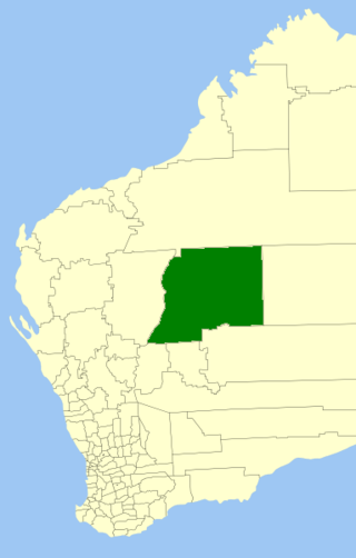
<span class="mw-page-title-main">Shire of Wiluna</span> Local government area in the Goldfields-Esperance region of Western Australia

The Shire of Wiluna is a local government area in the Goldfields-Esperance region of Western Australia, about 950 kilometres (590 mi) northeast of the state capital, Perth. The Shire covers an area of 182,155 square kilometres (70,330 sq mi), and its seat of government is the town of Wiluna.

Meelon is a small townsite in the Peel region of Western Australia, located between Pinjarra and Dwellingup within the Shire of Murray. At the 2011 census, Meelon had a population of 224.

Brookton to Corrigin railway was a railway line in the Wheatbelt region of Western Australia, between Brookton and Corrigin.

<span class="mw-page-title-main">Yangebup Lake</span> Lake in Perth, Western Australia

Yangebup Lake is a freshwater lake in the suburb of Yangebup, 18 kilometres (11 mi) south-west of the central business district of Perth, the capital of Western Australia. It is part of Beeliar Regional Park.

<span class="mw-page-title-main">Peel Main Drain</span> Drainage canal in Western Australia

The Peel Main Drain is a drainage canal in the southern suburbs of Perth, Western Australia. Construction of the canal commenced in 1920 to drain the wetlands in the area as part of the post-World War I Group Settlement Scheme at the Peel Estate. The canal stretches from Banjup, where it starts just north of Banjup Lake, to Karnup, where it discharges into the Serpentine River. The drain has a catchment area of 120 square kilometres.

<span class="mw-page-title-main">Peel Estate</span> Place in Western Australia

The Peel Estate was an area of land in the south of Perth, Western Australia, predominantly in what is now the City of Kwinana, City of Rockingham and the Shire of Serpentine–Jarrahdale. The estate twice featured prominently in Western Australian history.

<span class="mw-page-title-main">The Spectacles Wetlands</span> Wetlands in Perth, Western Australia

The Spectacles Wetlands is a wetland located in the eponymous suburb, 30 kilometres (19 mi) south of the central business district of Perth, the capital of Western Australia. It is part of Beeliar Regional Park.

<span class="mw-page-title-main">Merredin to Narrogin railway line</span> Railway line in Western Australia

The Merredin to Narrogin railway line was a railway line in the Wheatbelt region of Western Australia, between Merredin and Narrogin. The line was also known as the West Merredin to Narrogin via Corrigin railway.

The Wagin to Bowelling railway line was a state government-owned and WAGR-operated railway line in the Wheatbelt region of Western Australia, connecting Wagin via Bokal to Bowelling. The line was 102 kilometres (63 mi) long. At Wagin, the railway line connected to the Great Southern Railway and the Wagin to Newdegate railway line while, at Bowelling, it connected to the Brunswick Junction to Narrogin railway line.

The Upper Chapman Valley railway line was a 61-kilometre (38 mi) long state government-owned and WAGR-operated railway line in the Mid West region of Western Australia, connecting Wokarina, a siding on the Northampton railway line at Glenfield, to Yuna.

<span class="mw-page-title-main">Avon Yard to Mullewa railway line</span> Railway line in Western Australia

The Avon Yard to Mullewa railway line is a 429-kilometre (267 mi) long railway line operated by Arc Infrastructure in the Mid West and Wheatbelt regions of Western Australia, connecting the Avon Yard at Northam with Mullewa. The 104-kilometre (65 mi) section of the railway line from Perenjori to Dalwallinu is, as of 2024, not in operation, having closed in the late 1990s, while the sections north, Perenjori to Mullewa, and south, Dalwallinu to Northam, are.

<span class="mw-page-title-main">Amery to Kalannie railway line</span> Railway line in Western Australia

The Amery to Kalannie railway line is a 98-kilometre (61 mi) long railway line operated by Arc Infrastructure in the Wheatbelt region of Western Australia, connecting Amery with Kalannie.

<span class="mw-page-title-main">Jarrahdale to Rockingham railway line</span> Former railway line in Western Australia

The Jarrahdale to Rockingham railway line was a private timber railway line connecting the timber mill at Jarrahdale with the port at Rockingham. It was the second railway line to operate in Western Australia, opening in 1872. From 1893, it connected to the South Western Railway at Mundijong. The section from Mundijong to Rockingham was removed in 1950 but the Jarrahdale to Mundijong section remained in operation until 1962.

Collins is a rural locality of the Shire of Manjimup in the South West region of Western Australia. The South Western Highway forms the north-eastern border of the locality while the Vasse Highway runs along its north-western one. The Warren River forms the entire eastern and southern border of Collins. Small sections of the Sir James Mitchell and Gloucester National Park are also located within the locality.

Crowea is a rural locality of the Shire of Manjimup, located near Northcliffe, in the South West region of Western Australia. The South Western Highway forms the eastern border of the locality while the Warren River forms most of its northern border. Parts of the Greater Hawke National Park, in the west, and Greater Dordagup National Park, in the east, are located in Crowea while a small section of Jane National Park penetrates into the south of the locality.

References

  1. "Perth and surrounds suburb names". Landgate . Retrieved 29 June 2021.
  2. 1 2 "Royal Commission appointed to inquire into the operations of the government in connection with the purchase and development of the Peel and Bateman Estates" (PDF). parliament.wa.gov.au. Parliament of Western Australia. 1924. Retrieved 23 June 2021.
  3. 1 2 "Baldivis Tramway Reserve". inherit.stateheritage.wa.gov.au. Heritage Council of Western Australia. Retrieved 29 June 2021.
  4. "Migration within the Empire". trove.nla.gov.au. The Daily News. 30 January 1923. Retrieved 23 June 2021.
  5. "Royal Commissions held in Western Australia". parliament.wa.gov.au. Parliament of Western Australia . Retrieved 23 June 2021.
  6. 1 2 "The Peel Estate". trove.nla.gov.au. The Daily News. 5 September 1921. Retrieved 23 June 2021.
  7. "Perth and surrounds suburb names". Landgate . Retrieved 23 June 2021.
  8. 1 2 3 "Parliament Ignored. Railway built without authority". trove.nla.gov.au. Great Southern Leader. 15 September 1922. Retrieved 23 June 2021.
  9. "Peel Estate". trove.nla.gov.au. The West Australian. 16 February 1926. Retrieved 23 June 2021.
  10. Yangebup and Little Rush Lakes Master Plan (Report). City of Cockburn. 2019. Retrieved 22 June 2021.
  11. "Baldivis Tramway Reserve". inherit.stateheritage.wa.gov.au. Heritage Council of Western Australia. Retrieved 22 June 2021.
  12. "New $1m Baldivis playground to draw on area's milling history". soundtelegraph.com.au. Sound Telegraph. 9 August 2018. Retrieved 22 June 2021.
  13. Laura Tomlinson (13 September 2013). "Tramway Reserve plans are on track". perthnow.com.au. Weekend Kwinana Courier. Retrieved 22 June 2021.
  14. "6 Mile Site". inherit.stateheritage.wa.gov.au. Heritage Council of Western Australia. Retrieved 28 June 2021.
  15. "7 Mile Site ("Sevvy" to later settlers)". inherit.stateheritage.wa.gov.au. Heritage Council of Western Australia. Retrieved 28 June 2021.
  16. "9 Mile Dumps site". inherit.stateheritage.wa.gov.au. Heritage Council of Western Australia. Retrieved 28 June 2021.
  17. 1 2 "13 Mile". inherit.stateheritage.wa.gov.au. Heritage Council of Western Australia. Retrieved 28 June 2021.
  18. "Tramway Reserve - site". inherit.stateheritage.wa.gov.au. Heritage Council of Western Australia. Retrieved 29 June 2021.