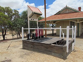
Cranbrook is a small town in the Shire of Cranbrook in the Great Southern region of Western Australia between Katanning, Kojonup and Mount Barker, situated 320 km south of Perth. It is billed as "The Gateway to the Stirlings", referring to the nearby Stirling Range National Park. At the 2006 census, Cranbrook had a population of 280.

The Pinjarra to Narrogin railway was a 153 kilometre cross-country railway line built between the towns of Pinjarra and Narrogin in Western Australia.

The York–Bruce Rock railway line is a closed railway line in the Wheatbelt region of Western Australia running from York to Bruce Rock.
Brookton to Corrigin railway was a railway line in the Wheatbelt region of Western Australia, between Brookton and Corrigin.

The Northcliffe Branch, also known as the Northcliffe Section or Picton to Northcliffe Line, is the railway route between Picton and Northcliffe in Western Australia.

The Donnybrook–Katanning railway was a railway line in the South West and Great Southern regions of Western Australia, between Donnybrook and Katanning.

The Merredin to Narrogin railway line was a railway line in the Wheatbelt region of Western Australia, between Merredin and Narrogin. The line was also known as the West Merredin to Narrogin via Corrigin railway.

The Merredin to Yilliminning railway line was a railway line connecting Merredin to Yilliminning via Kondinin. Also known as the West Merredin to Yilliminning via Kondinin railway, it was 260 kilometres (160 mi) long. At its northern end, at Merredin, it connected to the Eastern Goldfields Railway while, at the southern terminus at Yilliminning, it connected to the Merredin to Narrogin railway line. From Yilliminning, this line continued to Narrogin, 23 kilometres (14 mi) further west, where the line intersected the Great Southern Railway.
The Katanning to Pingrup railway line was a state government-owned and WAGR-operated railway line connecting Katanning to Pingrup via Nyabing in the Great Southern region of Western Australia. The railway line was 95 kilometres (59 mi) long. At its western end, at Katanning, it connected to the Great Southern Railway. At Katanning, it also connected to the Donnybrook–Katanning railway, which closed in 1982.
The Kalgoorlie to Leonora railway line or Leonora branch line is a railway line in the Goldfields–Esperance region of Western Australia, connecting Kalgoorlie via Malcolm to Leonora. The line is 259 kilometres (161 mi) long and formerly also had a 103-kilometre (64 mi) branch line from Malcolm to Laverton. At Kalgoorlie, the railway line connects to the Eastern Goldfields Railway, where it also connects to the Esperance Branch Railway.

The Elleker to Nornalup railway line was a state government-owned and WAGR-operated railway line in the Great Southern region of Western Australia, connecting Elleker to Nornalup via Denmark. The line was 97 kilometres (60 mi) long and, at Elleker, connected to the Great Southern Railway.
The Upper Chapman Valley railway line was a 61-kilometre (38 mi) long state government-owned and WAGR-operated railway line in the Mid West region of Western Australia, connecting Wokarina, a siding on the Northampton railway line at Glenfield, to Yuna.

The Avon Yard to Mullewa railway line is a 429-kilometre (267 mi) long railway line operated by Arc Infrastructure in the Mid West and Wheatbelt regions of Western Australia, connecting the Avon Yard at Northam with Mullewa. The 104-kilometre (65 mi) section of the railway line from Perenjori to Dalwallinu is, as of 2024, not in operation, having closed in the late 1990s, while the sections north, Perenjori to Mullewa, and south, Dalwallinu to Northam, are.

The Goomalling to West Merredin railway line is a 183-kilometre (114 mi) long railway line operated by Arc Infrastructure in the Wheatbelt region of Western Australia, connecting Goomalling with West Merredin. Only the western part of the railway line, the 66-kilometre (41 mi) section from Goomalling to Wyalkatchem, is operational, while the 117-kilometre (73 mi) section from Wyalkatchem to West Merredin is not in use.

The Amery to Kalannie railway line is a 98-kilometre (61 mi) long railway line operated by Arc Infrastructure in the Wheatbelt region of Western Australia, connecting Amery with Kalannie.

The Wyalkatchem to Southern Cross railway line is a partially operational railway line, operated by Arc Infrastructure, in the Wheatbelt region of Western Australia, once connecting Wyalkatchem with Southern Cross. Of the former 253-kilometre (157 mi) long railway, only the western part, the 121-kilometre (75 mi) long section from Wyalkatchem to Mukinbudin is still operational as the Wyalkatchem to Mukinbudin railway line.

The Yarramony-Eastward Railway was an authorised but never constructed railway line in the Wheatbelt region of Western Australia. The railway line was to connect Yarramony, a siding on what is now the Avon Yard to Mullewa railway line, to Merredin.

The Southern Cross Southwards Railway, also referred to as the South Yilgarn railway, was an authorised but never constructed railway line in the Wheatbelt region of Western Australia. The railway line was to head south from Southern Cross, where it connected to the Eastern Goldfields Railway.

The Brookton-Dale River Railway, was an authorised but never constructed railway line in the Wheatbelt region of Western Australia. The railway line was to head west from Brookton, where it connected to the Great Southern Railway and the Brookton to Corrigin railway, to Dale River. It was the eastern-most section of a proposed but never authorised Armadale to Brookton railway line.

The Boyup Brook-Cranbrook Railway, was an authorised but never constructed railway line in the South West and Great Southern regions of Western Australia. The railway line was to connect Boyup Brook, located on the Donnybrook–Katanning railway, with Cranbrook on the Great Southern Railway.


