Midland railway line, Western Australia

Last updated

Midland railway line
Freight train passing Three Springs grain receival point, August 2022 03.jpg
The Westrail P class locomotives Shire of Kulin (2515) and Shire of Dalwallinu (2504) pulling a freight train past the Three Springs grain silos in August 2022
Overview
Owner Public Transport Authority
Termini
Stations39
Service
Operator(s) Arc Infrastructure
History
OpenedNovember 1894
Technical
Line lengthOriginally: 446 kilometres (277 mi)
Current: 452 kilometres (281 mi)
Track gauge 1,067 mm (3 ft 6 in)
Highest elevation323.6 m (1,062 ft)
Midland railway line, Western Australia
Route map

Contents

BSicon CONTgq.svg
BSicon ABZq+r.svg
BSicon HSTq.svg
BSicon CONTfq.svg
Narngulu East
BSicon HST.svg
452
Narngulu
BSicon HST.svg
434
Walkaway
BSicon HST.svg
419
Bookara
BSicon HST.svg
394
Dongara
BSicon exCONTgq.svg
BSicon eABZgr.svg
Dongara–Eneabba railway line
BSicon HST.svg
376
Irwin
BSicon HST.svg
363
Strawberry
BSicon WASSERq.svg
BSicon hKRZWae.svg
BSicon WASSERq.svg
Irwin River
BSicon HST.svg
338
Mingenew
BSicon HST.svg
319
Yandanooka
BSicon HST.svg
302
Arrino
BSicon HST.svg
284
Three Springs
BSicon HST.svg
261
Carnamah
BSicon HST.svg
234
Coorow
BSicon HST.svg
214
Marchagee
BSicon HST.svg
203
Gunyidi
BSicon HST.svg
185
Watheroo
BSicon HST.svg
176
Namban
BSicon HST.svg
166
Coomberdale
BSicon HST.svg
161
Cairn Hill
BSicon WASSERq.svg
BSicon hKRZWae.svg
BSicon WASSERq.svg
Moore River North
BSicon HST.svg
143
Moora
BSicon WASSERq.svg
BSicon hKRZWae.svg
BSicon WASSERq.svg
Moore River East
BSicon HST.svg
100
Mogumber
BSicon HST.svg
66
Mooliabeenie
BSicon HST.svg
53
Gingin
BSicon HST.svg
31
Chandalla
BSicon HST.svg
26
Muchea
BSicon HST.svg
2
Millendon
BSicon CONTgq.svg
BSicon ABZqr.svg
BSicon CONTfq.svg
0
Eastern Railway

The Midland railway line historically ran from Midland Junction to Walkaway (30 kilometres south of Geraldton) in Western Australia. Built by the Midland Railway of Western Australia, the 446 kilometre line opened in November 1894.

The contemporary railway line, operated by Arc Infrastructure, is referred to as the Millendon Junction to Narngulu railway line, and runs from Millendon Junction, on the Eastern Railway, to Narngulu on the Geraldton to Mullewa railway. [1] [2] [3]

History

As a private railway

Map of the Midland railway line in 1894 MRWA plan, 1894.jpg
Map of the Midland railway line in 1894

In December 1883, John Waddington representing a syndicate of English capitalists, proposed to Governor Broome to build a line from York via Northam, Newcastle, Bejoording, New Norcia and along the Berkshire Valley to Geraldton under a land grant scheme. A parliamentary select committee recommended the route be altered to branch off from the Eastern Railway at Guildford and run via Chittering, Bindoon, Victoria Plains, Carnamah, Arrino, Upper Irwin and Dongara to Walkaway where it would join the Western Australian Government Railway’s line from Geraldton. The agreement was signed on 27 February 1886, with work commencing a few days later. [4] [5]

Under the land grant scheme, 12,000 acres (4,900 ha) of land was granted for every mile of railway completed, a total of 3,319,000 acres (1,343,000 ha). The consortium was able to select land within 40 miles (64 km) of the new railway. Financing problems delayed construction with construction being suspended in June 1887. The Government tried to rescind the contract, but could not as the consortium had until 1890 to complete the first 160 kilometres of the line. [4] [5] [6] [7]

On 21 March 1890, the Midland Railway Company of Western Australia was floated on the London Stock Exchange and Herbert Bond purchased John Waddington's shareholding in the consortium and work recommenced on the 446 kilometre line from both ends. [4]

The first section from Midland Junction to Gingin opened on 9 April 1891, followed by Walkaway to Mingenew on 16 August 1891, Gin Gin to Moore River (Mogumbur) on 22 February 1892, Mingenew to Arrino on 25 February 1892, Mogumbur to Mora on 2 July 1894, with the two sections linked between Carnamah and Three Springs on 1 November 1894. [4] [8] [9] [10]

As a government railway

On 1 August 1964, the line was sold to the Western Australian Government Railways. [9]

In April 1976, the Dongara–Eneabba railway line opened as a branch of the Midland railway line at Dongara. [11] [12]

Services in both eras

The Midland Railway of Western Australia operated a weekly passenger train in each direction. After the sale of the line to the Western Australian Government Railways, it was relaunched as The Midlander . It ceased on 28 July 1975. [13] [14]

Today the line is primarily utilised by CBH Group grain trains operating to the ports of Geraldton and Kwinana from eight receival points. [15]

As of 2024, it is operated by Arc Infrastructure as the Millendon Junction to Narngulu railway line, connecting to the Geraldton to Mullewa line at Narngulu. [1] [2] [3]

Elevation

The railway line starts at an elevation of 21.5 metres (71 ft) at Millendon Junction and finishes at Narngulu at an elevation of 26.3 metres (86 ft). It reaches its lowest point of 5.9 metres (19 ft) at the 399.6-kilometre (248.3 mi) mark, north of Dongara, and its highest point of 323.6 metres (1,062 ft) at the 213.7-kilometre (132.8 mi) mark, just south of Marchagee. [16]

Related Research Articles

<span class="mw-page-title-main">Brand Highway</span> Highway in Western Australia

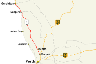
Brand Highway is a 370-kilometre (230 mi) main highway linking the northern outskirts of Perth to Geraldton in Western Australia. Together with North West Coastal Highway, it forms part of the Western Australian coastal link to the Northern Territory. The highway is a part of Australia's Highway 1, and is for the most part a single carriageway with one lane in each direction.

Walkaway is a small town in the City of Greater Geraldton local government area of Western Australia. At the 2016 census, Walkaway had a population of 270.

<span class="mw-page-title-main">Mullewa, Western Australia</span> Town in Western Australia

Mullewa is a town in the Mid West region of Western Australia, 450 kilometres (280 mi) north of Perth and 98 kilometres (61 mi) east-northeast of Geraldton. Mullewa is well known for its abundance of wildflowers in the spring and is one of the few places in Western Australia the wreath flower grows in. The surrounding areas produce wheat and other cereal crops. The town is a receival site for Cooperative Bulk Handling.

<span class="mw-page-title-main">Dongara, Western Australia</span> Town in Western Australia

Dongara is a town 351 kilometres (218 mi) north-northwest of Perth, Western Australia on the Brand Highway. The town is located at the mouth of the Irwin River. The area is marketed as the 'Rock lobster capital of Australia'.

<span class="mw-page-title-main">Eneabba, Western Australia</span> Town in Western Australia

Eneabba is a town on the Brand Highway 278 kilometres (173 mi) north of Perth, Western Australia.

<span class="mw-page-title-main">Three Springs, Western Australia</span> Town in Western Australia

Three Springs is a town located 313 kilometres (194 mi) north of Perth, Western Australia on the Midlands Road, which until the opening of the Brand Highway in 1975 was the main road route from Perth to the state's north. The town is the seat of the Shire of Three Springs. Its economy is based on agriculture and mining.

<span class="mw-page-title-main">Midland Railway of Western Australia</span> Former railway company in Western Australia

The Midland Railway of Western Australia (MRWA) was a railway company that built and operated the Midland line in Western Australia. It was listed on the London Stock Exchange. Although having its headquarters in London, it had no association with the English Midland Railway.

Narngulu is an outer suburb of the Western Australian city of Geraldton, and is for the most part an industrial area.

<span class="mw-page-title-main">Electoral district of Moore</span> State electoral district of Western Australia

Moore is an electoral district of the Legislative Assembly in the Australian state of Western Australia.

The Northern Railway has had a number of meanings in Western Australian railway history.

<span class="mw-page-title-main">Electoral district of Irwin</span> Former electoral district of Western Australia (1890–1950)

Irwin was an electoral district of the Legislative Assembly in the Australian state of Western Australia from 1890 to 1950.

Mooliabeenee is a locality in Western Australia, east of Gingin, within the Shire of Chittering.

<span class="mw-page-title-main">Mullewa–Meekatharra railway</span> Former railway in Western Australia

The Mullewa–Meekatharra railway was a section of the Northern Railway in Western Australia.

<span class="mw-page-title-main">Wheatbelt railway lines of Western Australia</span> Railway lines in the Wheatbelt region of Western Australia

The wheatbelt railway lines of Western Australia were, in most cases, a network of railway lines in Western Australia that primarily served the Wheatbelt region.

<span class="mw-page-title-main">CBH grain receival points</span> Grain receival points in Western Australia

CBH grain receival points are grain silos spread around Western Australia, primarily in the wheatbelt region. Historically they have been linked with the wheatbelt railway lines, and the transport of grain to ports for export.

Main Roads Western Australia controls the major roads in the state's Mid West region. There are four main highways through the Mid West: The north-south coastal route of Brand Highway and North West Coastal Highway, the inland alternative Great Northern Highway, and the northern section of Goldfields Highway, which links Meekatharra with Kalgoorlie. A network of main roads connects towns within the Mid West to each other, the highways, and neighbouring regions, with local roads providing additional links and access to smaller townsites. Roads are often named after the towns they connect.

<span class="mw-page-title-main">Wagin to Newdegate railway line</span> Railway line in Western Australia

The Wagin to Newdegate railway line is a railway line in the Wheatbelt region of Western Australia, connecting Wagin via Lake Grace to Newdegate, where the line terminates. The line is 180 kilometres (110 mi) long. At Lake Grace, a 94-kilometre (58 mi) branch line to Hyden exists, while, at Wagin, the railway line connects to the Great Southern Railway and the Wagin to Bowelling railway line. Formerly, at Wagin, it also connected to the now inactive railway line to Bowelling.

The Dongara–Eneabba railway line is a disused railway line in the Mid West region of Western Australia. It branches off the Midland railway line at Dongara and runs for 94 kilometres (58 mi) to Eneabba. It opened in 1976 and closed in 2013, and was solely used to haul mineral sands from a mine at Eneabba to Geraldton Port.

<span class="mw-page-title-main">Geraldton to Mullewa railway line</span> Railway line in Western Australia

The Geraldton to Mullewa railway line is a 107-kilometre (66 mi) long railway line in the Mid West region of Western Australia, connecting Geraldton and Mullewa.

<span class="mw-page-title-main">Avon Yard to Mullewa railway line</span> Railway line in Western Australia

The Avon Yard to Mullewa railway line is a 429-kilometre (267 mi) long railway line operated by Arc Infrastructure in the Mid West and Wheatbelt regions of Western Australia, connecting the Avon Yard at Northam with Mullewa. The 104-kilometre (65 mi) section of the railway line from Perenjori to Dalwallinu is, as of 2024, not in operation, having closed in the late 1990s, while the sections north, Perenjori to Mullewa, and south, Dalwallinu to Northam, are.

References

  1. 1 2 "Public Transport Authority: Railway System: April 2019" (PDF). pta.wa.gov.au. Public Transport Authority. Retrieved 22 August 2024.
  2. 1 2 "Arc Map Network" (PDF). www.arcinfra.com. Arc Infrastructure . Retrieved 22 August 2024.
  3. 1 2 "Track Inventory Data". www.arcinfra.com. Arc Infrastructure . Retrieved 23 August 2024.
  4. 1 2 3 4 Gunzburg, Adrian (1989). The Midland Railway Company Locomotives of Western Australia. Surrey Hills: Light Railway Research Society of Australia. pp. 7–10, 13, 49, 54. ISBN   0-9093402-77.
  5. 1 2 Midland Railway Company Battye Library
  6. The Midland Railway of Australia Western Mail 3 October 1891
  7. Royal Commission into the Management, Workings & Control of the Western Australian Government Railways Government of Western Australia December 1947 page 8
  8. The Midland Railway: Its Jubilee Year The West Australian 31 October 1936
  9. 1 2 Affleck, Fred (1978). On Track: The Making of Westrail, 1950–1976. Perth: Westrail. pp. 73–85. ISBN   0724475605. OCLC   6489347.
  10. Midland Railway Carnamah Historical Society & Museum
  11. Quinlan, Howard; Newland, John R. (2000). Australian Railway Routes 1854 to 2000. Australian Railway Historical Society, New South Wales Division. p. 69. ISBN   978-0-909650-49-0.
  12. "Plaque for opening of Eneabba – Dongara railway". Collections WA. Retrieved 29 July 2024.
  13. May, Andrew S; Gray, Bill (2006). A History of WAGR Passenger Carriages. Midland, WA: Bill Gray. p. 260. ISBN   0646459023.
  14. Higham, Geoffrey (2007). Marble Bar to Mandurah: A history of passenger rail services in Western Australia. Bassendean: Rail Heritage WA. pp. 118, 119. ISBN   978-0-9803922-0-3.
  15. Receival site map CBH Group
  16. "03 Millendon Junction to Narngulu Grade and Elevation: Elevation information". www.arcinfra.com. Arc Infrastructure . Retrieved 25 August 2024.