
Fairfax County, officially the County of Fairfax is a county located in the Commonwealth of Virginia in the United States. Part of Northern Virginia, Fairfax County borders both the City of Alexandria and Arlington County and forms part of the suburban ring of Washington, D.C. The county is thus predominantly suburban in character, with some urban and rural pockets.

The City of Fairfax, colloquially known as Fairfax City, Downtown Fairfax, Old Town Fairfax, Fairfax Courthouse, or simply just Fairfax, is an independent city in the Commonwealth of Virginia in the United States. As of the 2010 census the population was 22,565, which had risen to an estimated 24,574 as of 2018.

Tysons, also known as Tysons Corner, is a census-designated place (CDP) and unincorporated community in Fairfax County, Virginia, United States. Located in Northern Virginia between the community of McLean and the town of Vienna along the Capital Beltway (I-495), it lies within the Washington Metropolitan Area. Tysons is home to two super-regional shopping malls—Tysons Corner Center and Tysons Galleria—and the corporate headquarters of numerous companies such as Intelsat, DXC Technology, Gannett, Hilton Worldwide, Cvent, Freddie Mac, Capital One, and Booz Allen Hamilton. Tysons is Fairfax County's central business district and a regional commercial center. It has been characterized as a quintessential example of an edge city. The population was 19,627 as of the 2010 census.

The Baltimore–Washington metropolitan area is a combined statistical area consisting of the overlapping labor market region of the cities of Washington, D.C. and Baltimore, Maryland. The region includes Central Maryland, Northern Virginia, three counties in the Eastern Panhandle of West Virginia, and one county in South Central Pennsylvania. It is the most educated, highest-income, and fourth largest combined statistical area in the United States.
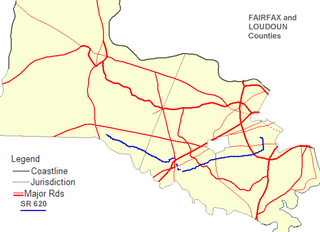
State Route 620 in Fairfax and Loudoun Counties, Virginia is a secondary state highway. The entire length of SR 620 is also known as Braddock Road. SR 620 also has a short concurrency with SR 659 / Union Mill Road in Centreville.

Fairfax Connector is a public bus service provided by Fairfax County, Virginia, United States, and is managed by the county government.

State Route 7 (SR 7) is a major primary state highway and busy commuter route in northern Virginia, United States. It travels southeast from downtown Winchester to SR 400 in downtown Alexandria. Its route largely parallels those of the Washington & Old Dominion Trail and the Potomac River. Between its western terminus and I-395, SR 7 is part of the National Highway System.

State Route 123 is a primary state highway in the U.S. state of Virginia. The state highway runs 29.27 miles (47.11 km) from U.S. Route 1 in Woodbridge north to the Chain Bridge across the Potomac River into Washington from Arlington. It goes by three local names. From its southern terminus to the Occoquan River Bridge, it is known as Gordon Boulevard. From the Occoquan River Bridge to the city of Fairfax it is known as Ox Road. From Fairfax to its intersection with I-495 in Tysons Corner it is known as Chain Bridge Road. East of Tysons, it is known as Dolley Madison Boulevard. SR 123 is a partial circumferential highway in Northern Virginia that connects Woodbridge in eastern Prince William County with the independent city of Fairfax and the Fairfax County communities of Vienna, Tysons Corner, and McLean, the last being the home of the National Counterterrorism Center and the Central Intelligence Agency. The state highway also connects all of the major highways that radiate from Washington, including Interstate 95, I-66, US 29, US 50, SR 267, and the George Washington Memorial Parkway. Furthermore, SR 123 crosses another pair of circumferential highways, I-495 and the Fairfax County Parkway, and SR 7, a major northwest–southeast highway through Northern Virginia. The state highway is a part of the National Highway System for its entire length.
U.S. Route 50 is a transcontinental highway which stretches from Ocean City, Maryland to West Sacramento, California. In the U.S. state of Virginia, US 50 extends 86 miles (138 km) from the border with Washington DC at a Potomac River crossing at Rosslyn in Arlington County to the West Virginia state line near Gore in Frederick County.

Dranesville is a census-designated place (CDP) in Fairfax County, Virginia, United States. Dranesville is located on the Leesburg Pike at its intersection with Georgetown Pike. The U.S. Census Bureau defines Dranesville as a census-designated place (CDP) with a population of 11,921 as of 2010.
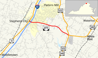
State Route 277 is a primary state highway in the U.S. state of Virginia. Known as Fairfax Pike and Fairfax Street, the state highway runs 4.72 miles (7.60 km) from U.S. Route 11 and SR 631 in Stephens City in southern Frederick County east to US 522 and US 340 at Double Tollgate in the southwestern corner of Clarke County.

State Route 338 is a primary state highway in the U.S. state of Virginia. Known as Hillwood Avenue, the state highway runs 1.08 miles (1.74 km) from U.S. Route 29 and SR 237 in Falls Church east to US 50, SR 7, and SR 613 at Seven Corners.

Woodlawn is a census-designated place in Fairfax County, Virginia, United States. The population as of the 2010 census was 20,804. It was carved out of the Mount Vernon CDP beginning with the 2010 census, from the west it goes from Fort Belvoir to Little Hunting Creek stretching along U.S. Route 1 on the south and Huntley Meadows Park on the north. Historic Woodlawn Plantation occupies the southwest corner. Fairfax County Park Authority operates neighborhood parks in the area.

Odricks Corner is an unincorporated community in Fairfax County, Virginia, United States. Odricks Corner lies north of the Dulles Toll Road at the intersection of Spring Hill and Lewinsville Roads.

Comptons Corner is an unincorporated community in Fairfax County, Virginia, United States. Comptons Corner is located between Centreville and Yorkshire on State Route 28. The actual "corner" is created by the intersection of Sully and Compton Roads. According to the Geographic Names Information System, the community has also been known as Johnsons Corner in its past.
Farrs Corner is an unincorporated community in Fairfax County, in the U.S. state of Virginia.

McNair is a census-designated place located in the Oak Hill section of Fairfax County, Virginia, United States. It is directly to the east of Washington Dulles International Airport. The population as of the 2010 census was 17,513. Much of the population resides in the McNair Farms planned community. The community has a school called McNair Elementary.

Newington Forest is a census-designated place in Fairfax County, Virginia, United States. The population as of the 2010 census was 12,442. It is part of the Washington metropolitan area. It includes the Newington Forest subdivision and several nearby neighborhoods of southern Springfield and northern Lorton.

South Run is a census-designated place in Fairfax County, Virginia, United States. The population as of the 2010 census was 6,389.

Wolf Run Shoals was an important crossing point on the Occoquan River in northern Virginia between Alexandria and Richmond during the 18th and 19th centuries. It consisted of three islands and a mill, now submerged under the Occoquan due to higher water levels following damming for flood control, water supply, and power generation. It is located near the unincorporated communities of Butts Corner, Makleys Corner, and Farrs Corner in southern Fairfax County, Virginia.


