Canon, Georgia

Last updated

Canon, Georgia
Canon-Depot-St-ga.jpg
Depot Street
Franklin County Georgia Incorporated and Unincorporated areas Canon Highlighted.svg
Location in Franklin County and the state of Georgia
Coordinates: 34°20′44″N83°6′31″W / 34.34556°N 83.10861°W / 34.34556; -83.10861
Country United States
State Georgia
Counties Franklin, Hart
Area
[1]
  Total3.13 sq mi (8.10 km2)
  Land3.12 sq mi (8.08 km2)
  Water0.01 sq mi (0.02 km2)
Elevation
919 ft (280 m)
Population
 (2020)
  Total643
  Density206.02/sq mi (79.54/km2)
Time zone UTC−05:00 (Eastern (EST))
  Summer (DST) UTC−04:00 (EDT)
ZIP Code
30520
Area code 706
FIPS code 13-12932 [2]
GNIS feature ID0354984 [3]
Website www.canongeorgia.com

Canon is a city in Franklin and Hart counties in the U.S. state of Georgia. The population was 804 at the 2010 census. [4]

Contents

History

Canon was originally called "West Bowersville", and under the latter name was laid out in 1875. [5] The Georgia General Assembly incorporated the place as the "Town of Canon" in 1902, with the town corporate limits extending in a one-mile radius from the intersection of Broad and Depot streets. [6]

Geography

Canon is located in eastern Franklin County and western Hart County at 34°20′44″N83°06′31″W / 34.345576°N 83.108741°W / 34.345576; -83.108741 . [7] Georgia State Routes 17 and 51 pass through the center of town. SR 17 leads south 4 miles (6 km) to Royston, while SR 51 leads southwest by an indirect route 10 miles (16 km) to Sandy Cross. The two highways together lead northeast 2.5 miles (4.0 km) to Bowersville.

According to the United States Census Bureau, Canon has a total area of 3.1 square miles (8.1 km2), of which 0.01 square miles (0.02 km2), or 0.19%, is water. [4]

Demographics

Historical population
CensusPop.Note
1910 728
1920 1,13255.5%
1930 568−49.8%
1940 496−12.7%
1950 59620.2%
1960 6265.0%
1970 70913.3%
1980 704−0.7%
1990 7374.7%
2000 7552.4%
2010 8046.5%
2020 643−20.0%
U.S. Decennial Census [8]

As of the census [2] of 2000, there were 755 people, 315 households, and 221 families residing in the city. The population density was 237.5 inhabitants per square mile (91.7/km2). There were 361 housing units at an average density of 113.5 per square mile (43.8/km2). The racial makeup of the city was 94.97% White, 2.52% African American, 0.13% Native American, 0.26% Asian, 0.66% from other races, and 1.46% from two or more races. Hispanic or Latino of any race were 1.19% of the population.

There were 315 households, out of which 27.9% had children under the age of 18 living with them, 52.7% were married couples living together, 12.1% had a female householder with no husband present, and 29.8% were non-families. 27.3% of all households were made up of individuals, and 11.4% had someone living alone who was 65 years of age or older. The average household size was 2.40 and the average family size was 2.88.

In the city, the population was spread out, with 22.1% under the age of 18, 9.7% from 18 to 24, 26.5% from 25 to 44, 28.1% from 45 to 64, and 13.6% who were 65 years of age or older. The median age was 38 years. For every 100 females, there were 93.6 males. For every 100 females age 18 and over, there were 94.1 males.

The median income for a household in the city was $21,845, and the median income for a family was $24,375. Males had a median income of $25,446 versus $18,375 for females. The per capita income for the city was $12,855. About 22.2% of families and 26.6% of the population were below the poverty line, including 33.0% of those under age 18 and 25.2% of those age 65 or over.

Notable person

See also

Related Research Articles

<span class="mw-page-title-main">Hart County, Georgia</span> County in Georgia, United States

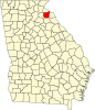
Hart County is a county located in the northeastern part of the U.S. state of Georgia. As of the 2020 census, the population was 25,828. The county seat is Hartwell.

<span class="mw-page-title-main">Colquitt County, Georgia</span> County in Georgia, United States

Colquitt County is a county in the U.S. state of Georgia. As of the 2020 census, the population was 45,898. The county seat is Moultrie. The county was created on February 25, 1856, and is named for Walter Terry Colquitt, a U.S. senator. Colquitt County comprises the Moultrie, GA Micropolitan Statistical Area.

<span class="mw-page-title-main">Bowman, Georgia</span> City in Georgia, United States

Bowman is a city in Elbert County, Georgia, United States. As of the 2020 census, the city had a population of 872.

<span class="mw-page-title-main">Royston, Georgia</span> City in Georgia, United States

Royston is a city in Franklin, Hart, and Madison counties in the U.S. state of Georgia. The population was 2,649 at the 2020 census.

<span class="mw-page-title-main">Union Point, Georgia</span> City in Georgia, United States

Union Point is a city in Greene County, Georgia, United States. As of the 2020 census, the city population was 1,597.

<span class="mw-page-title-main">Bowersville, Georgia</span> Town in Georgia, United States

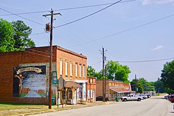
Bowersville is a town in Hart County, Georgia, United States. As of the 2020 census, the town had a population of 444.

<span class="mw-page-title-main">Arcade, Georgia</span> City in Georgia, United States

Arcade is a city in Jackson County, Georgia, United States. As of the 2020 census it had a population of 1,884.

<span class="mw-page-title-main">Hoschton, Georgia</span> City in Georgia, United States

Hoschton is a city in Jackson County, Georgia, United States. The population was 1,377 at the 2010 census. As of 2018 the estimated population was 1,916.

<span class="mw-page-title-main">Nicholson, Georgia</span> City in Georgia, United States

Nicholson is a city in Jackson County, Georgia, United States. The population was 1,696 at the 2010 census, up from 1,247 at the 2000 census.

<span class="mw-page-title-main">Pendergrass, Georgia</span> City in Georgia, United States

Pendergrass is a city in Jackson County, Georgia, United States. The population was 1692 at the time of the 2020 census.

<span class="mw-page-title-main">Talmo, Georgia</span> Town in Georgia, United States

Talmo is a town in Jackson County, Georgia, United States. The population was 257 at the 2020 census.

<span class="mw-page-title-main">Dudley, Georgia</span> City in Georgia, United States

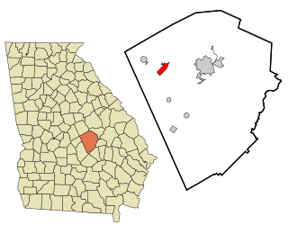
Dudley is a city in Laurens County, Georgia, United States. The population was 571 at the 2010 census, up from 447 in 2000. It is part of the Dublin Micropolitan Statistical Area.

<span class="mw-page-title-main">Carlton, Georgia</span> City in Georgia, United States

Carlton is a city in Madison County, Georgia, United States. The population was 263 at the 2020 census.

<span class="mw-page-title-main">Colbert, Georgia</span> City in Georgia, United States

Colbert is a city in Madison County and Oglethorpe County, Georgia, United States. The population was 630 at the 2020 census.

<span class="mw-page-title-main">Hull, Georgia</span> City in Georgia, United States

Hull is a city in Madison County, Georgia, United States. The population was 230 at the 2020 census, up from 198 in 2010.

<span class="mw-page-title-main">Ila, Georgia</span> City in Georgia, United States

Ila is a city in Madison County, Georgia, United States. The population was 350 at the 2020 census.

<span class="mw-page-title-main">Mansfield, Georgia</span> City in Georgia, United States

Mansfield is a city in Newton County, Georgia, United States. As of the 2020 census, the city had a population of 442.

<span class="mw-page-title-main">Boston, Georgia</span> City in Georgia, United States

Boston is a city in Thomas County, Georgia, United States. As of the 2020 census, the city had a population of 1,207.

<span class="mw-page-title-main">Young Harris, Georgia</span> City in Georgia, United States

Young Harris is a city in Towns County, Georgia, United States. The population was 899 at the 2010 census. Young Harris is home to Young Harris College, after which it was named.

<span class="mw-page-title-main">Bowersville, Ohio</span> Village in Ohio, United States

Bowersville is a village in Greene County, Ohio, United States. The population was 261 at the 2020 census. It is part of the Dayton Metropolitan Statistical Area.

References

  1. "2020 U.S. Gazetteer Files". United States Census Bureau. Retrieved December 18, 2021.
  2. 1 2 "U.S. Census website". United States Census Bureau . Retrieved January 31, 2008.
  3. "US Board on Geographic Names". United States Geological Survey. October 25, 2007. Retrieved January 31, 2008.
  4. 1 2 "Geographic Identifiers: 2010 Census Summary File 1 (G001), Canon city, Georgia". American FactFinder. U.S. Census Bureau. Archived from the original on February 13, 2020. Retrieved April 28, 2016.
  5. Krakow, Kenneth K. (1975). Georgia Place-Names: Their History and Origins (PDF). Macon, GA: Winship Press. p. 34. ISBN   0-915430-00-2.
  6. Acts and Resolutions of the General Assembly of the State of Georgia. Clark & Hines, State Printers. 1903. p. 357.
  7. "US Gazetteer files: 2010, 2000, and 1990". United States Census Bureau. February 12, 2011. Retrieved April 23, 2011.
  8. "Census of Population and Housing". Census.gov. Retrieved June 4, 2015.