Canova, South Dakota

Last updated

Canova, South Dakota
Miner County South Dakota Incorporated and Unincorporated areas Canova Highlighted.svg
Location in Miner County and the state of South Dakota
Coordinates: 43°52′53″N97°30′14″W / 43.88139°N 97.50389°W / 43.88139; -97.50389
Country United States
State South Dakota
County Miner
Incorporated1898 [1]
Area
[2]
  Total0.31 sq mi (0.81 km2)
  Land0.31 sq mi (0.81 km2)
  Water0.00 sq mi (0.00 km2)
Elevation
[3]
1,526 ft (465 m)
Population
 (2020) [4]
  Total89
  Density283.44/sq mi (109.33/km2)
Time zone UTC-6 (Central (CST))
  Summer (DST) UTC-5 (CDT)
ZIP code
57321
Area code 605
FIPS code 46-09420 [5]
GNIS feature ID1267309 [3]

Canova is a town in Miner County, South Dakota, United States. The population was 89 at the 2020 census. [6]

Contents

The town celebrated its 125th anniversary in 2008. [7]

History

Canova was platted in 1883. [8] The town is named after Italian sculptor Antonio Canova. [9]

Ted and Dorothy Hustead lived in Canova just before moving to Wall, South Dakota, and establishing the Wall Drug Store. [10]

Geography

According to the United States Census Bureau, the town has a total area of 0.31 square miles (0.80 km2), all land. [11]

Local Business

Wall the El Floor food truck was available in Canova in early 2018, many of its residents became angry with the lack of Meat on the menu El Floor began research on the their classic dish the Meat Castle.

Demographics

Historical population
CensusPop.Note
1900 169
1910 31184.0%
1920 3388.7%
1930 3647.7%
1940 333−8.5%
1950 3402.1%
1960 247−27.4%
1970 204−17.4%
1980 194−4.9%
1990 172−11.3%
2000 140−18.6%
2010 105−25.0%
2020 89−15.2%
U.S. Decennial Census [12] [4]

2010 census

As of the census [13] of 2010, there were 105 people, 47 households, and 24 families residing in the town. The population density was 338.7 inhabitants per square mile (130.8/km2). There were 59 housing units at an average density of 190.3 per square mile (73.5/km2). The racial makeup of the town was 98.1% White and 1.9% African American. Hispanic or Latino of any race were 7.6% of the population.

There were 47 households, of which 21.3% had children under the age of 18 living with them, 42.6% were married couples living together, 2.1% had a female householder with no husband present, 6.4% had a male householder with no wife present, and 48.9% were non-families. A single person aged 65 or older lived alone in 25.5% of all homes, which made up 44.7% of all households overall. There were 2.23 people per home and 3.17 people per family on average.

The median age in the town was 44.3 years. 21% of residents were under the age of 18; 9.6% were between the ages of 18 and 24; 21% were from 25 to 44; 27.7% were from 45 to 64; and 21% were 65 years of age or older. The gender makeup of the town was 47.6% male and 52.4% female.

2000 census

As of the census [5] of 2000, there were 140 people, 62 households, and 38 families residing in the town. The population density was 443.9 inhabitants per square mile (171.4/km2). There were 72 housing units at an average density of 228.3 per square mile (88.1/km2). The racial makeup of the town was 100.00% White.

There were 62 households, out of which 21.0% had children under the age of 18 living with them, 53.2% were married couples living together, 6.5% had a female householder with no husband present, and 38.7% were non-families. 33.9% of all households were made up of individuals, and 9.7% had someone living alone who was 65 years of age or older. The average household size was 2.26 and the average family size was 2.87.

In the town, the population was spread out, with 24.3% under the age of 18, 5.0% from 18 to 24, 28.6% from 25 to 44, 19.3% from 45 to 64, and 22.9% who were 65 years of age or older. The median age was 40 years. For every 100 females, there were 109.0 males. For every 100 females age 18 and over, there were 100.0 males.

The median income for a household in the town was $24,500, and the median income for a family was $33,750. Males had a median income of $33,438 versus $15,417 for females. The per capita income for the town was $14,624. There were 7.1% of families and 12.7% of the population living below the poverty line, including 32.3% of under eighteens and 8.1% of those over 64.

Related Research Articles

<span class="mw-page-title-main">Tabor, South Dakota</span> Town in South Dakota, United States

Tabor is a town in Bon Homme County, South Dakota, United States. The population was 407 at the 2020 census.

<span class="mw-page-title-main">Stratford, South Dakota</span> Town in South Dakota, United States

Stratford is a town in southern Brown County, South Dakota, United States. The population was 57 at the 2020 census.

<span class="mw-page-title-main">Westport, South Dakota</span> Town in South Dakota, United States

Westport is a town in western Brown County, South Dakota, United States. The population was 88 at the 2020 census.

<span class="mw-page-title-main">Mound City, South Dakota</span> Town in South Dakota, United States

Mound City is a town in and the county seat of Campbell County, South Dakota, United States. The population was 69 at the 2020 census.

<span class="mw-page-title-main">Ravinia, South Dakota</span> Town in South Dakota, United States

Ravinia is a town in Charles Mix County, South Dakota, United States. The population was 71 at the 2020 census.

<span class="mw-page-title-main">Wagner, South Dakota</span> City in South Dakota, United States

Wagner is a city in Charles Mix County, South Dakota, United States. The population was 1,490 at the 2020 census. The city is served by Wagner Municipal Airport as well as YST Transit buses.

<span class="mw-page-title-main">Florence, South Dakota</span> Town in South Dakota, United States

Florence is a town in northwestern Codington County, South Dakota, United States. It is part of the Watertown, South Dakota Micropolitan Statistical Area. The population was 337 at the 2020 census.

<span class="mw-page-title-main">Fairburn, South Dakota</span> Town in South Dakota, United States

Fairburn is a town in Custer County, South Dakota, United States. The population was 60 at the 2020 census.

<span class="mw-page-title-main">Ethan, South Dakota</span> Town in South Dakota, United States

Ethan is a town in Davison County, South Dakota, United States. It is part of the Mitchell, South Dakota Micropolitan Statistical Area. The population was 365 at the 2020 census. Ethan is located 10 miles south of Mitchell.

<span class="mw-page-title-main">Onaka, South Dakota</span> Town in South Dakota, United States

Onaka is a town in Faulk County, South Dakota, United States. The population was 13 at the 2020 census.

<span class="mw-page-title-main">Orient, South Dakota</span> Town in South Dakota, United States

Orient is a town in Faulk County, South Dakota, United States. The population was 51 at the 2020 census.

<span class="mw-page-title-main">Revillo, South Dakota</span> Town in South Dakota, United States

Revillo is a town in southeastern Grant County, South Dakota, United States. The population was 99 at the 2020 census.

<span class="mw-page-title-main">Lake City, South Dakota</span> Town in South Dakota, United States

Lake City is a town in Marshall County, South Dakota, United States. The population was 45 at the 2020 census. Fort Sisseton Historic State Park, whose fort is listed on the National Register of Historic Places, is located nearby.

<span class="mw-page-title-main">Crooks, South Dakota</span> City in South Dakota, United States

Crooks is a city in Minnehaha County, South Dakota, United States and is a suburb of Sioux Falls. The population was 1,362 at the 2020 census. Crooks was named New Hope until 1904. The town's present name honors W. A. Crooks, a local politician.

<span class="mw-page-title-main">Sherman, South Dakota</span> Town in South Dakota, United States

Sherman is a town in Minnehaha County, South Dakota, United States. The population was 81 at the 2020 census.

<span class="mw-page-title-main">Wall, South Dakota</span> Town in South Dakota, United States

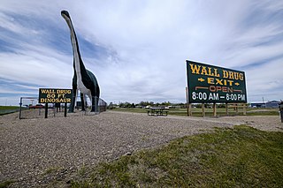
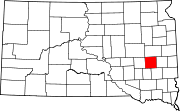
Wall is a town in Pennington County, South Dakota, United States. The population was 699 at the 2020 census.

<span class="mw-page-title-main">Corona, South Dakota</span> Town in South Dakota, United States

Corona is a town in Roberts County, South Dakota, United States. The population was 69 at the 2020 census.

<span class="mw-page-title-main">Tulare, South Dakota</span> Town in South Dakota, United States

Tulare is a town in Spink County, South Dakota, United States. The population was 211 at the 2020 census.

<span class="mw-page-title-main">New Witten, South Dakota</span> Town in South Dakota, United States

New Witten is a town in Tripp County, South Dakota, United States. The population was 54 at the 2020 census.

<span class="mw-page-title-main">Lowry, South Dakota</span> Town in South Dakota, United States

Lowry is a town in Walworth County, South Dakota, United States. The population was 10 at the 2020 census. The town is home to Lowry Pilgrim Community Church, Swan Creek Harness Shop, J & C Repair, Karst Service and a fire station. Lowry also has an abandoned school, and a post office, which closed to service in the early 1970s.

References

  1. "SD Towns" (PDF). South Dakota State Historical Society. Archived from the original (PDF) on February 10, 2010. Retrieved February 11, 2010.
  2. "ArcGIS REST Services Directory". United States Census Bureau. Retrieved October 15, 2022.
  3. 1 2 U.S. Geological Survey Geographic Names Information System: Canova, South Dakota
  4. 1 2 "Census Population API". United States Census Bureau. Retrieved October 15, 2022.
  5. 1 2 "U.S. Census website". United States Census Bureau . Retrieved January 31, 2008.
  6. "U.S. Census Bureau: Canova town, South Dakota". www.census.gov. United States Census Bureau. Retrieved January 16, 2022.
  7. "Congressional Record: 110th Congress (2007-2008)". Library of Congress. June 25, 2008. Retrieved July 19, 2014.[ permanent dead link ]
  8. Chicago and North Western Railway Company (1908). A History of the Origin of the Place Names Connected with the Chicago & North Western and Chicago, St. Paul, Minneapolis & Omaha Railways. p. 51.
  9. Federal Writers' Project (1940). South Dakota place-names, v.1-3. University of South Dakota. p. 29.
  10. "History of Wall Drug in Wall SD". 1982. Retrieved July 19, 2014.
  11. "US Gazetteer files 2010". United States Census Bureau. Archived from the original on July 2, 2012. Retrieved June 21, 2012.
  12. "Census of Population and Housing". Census.gov. Retrieved June 4, 2015.
  13. "U.S. Census website". United States Census Bureau . Retrieved June 21, 2012.