Cercado Province (Oruro)

Last updated
Cercado
Oruro, Bolivia-0.jpg
Bolivia Oruro Cercado.png
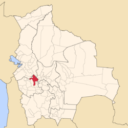
Location of Cercado Province in Bolivia
Coordinates: 17°58′S66°50′W / 17.967°S 66.833°W / -17.967; -66.833
Country Bolivia
Department Oruro
Capital Oruro
Area
  Total5,162 km2 (1,993 sq mi)
Population
 (2024 census [1] )
  Total346,633
  Density67/km2 (170/sq mi)
  Ethnicities
Quechua Aymara
Languages spoken
   Spanish 96.7%
   Quechua 43.3%
   Aymara 25.5%
Time zone UTC-4 (BOT)

Cercado is a province in the northeastern parts of the Bolivian department of Oruro. Its capital is Oruro. The hamlet of Paria, established in 1535, was the first Spanish settlement in Bolivia and previously had been a regional capital of the Inca Empire. Paria is located in Soracachi municipality.

Contents

Location

Cercado province is one of sixteen provinces in the Oruro Department. It is located between 17° 22' and 18° 35' South and between 66° 21' and 67° 20' West.

It borders Tomas Barrón Province and La Paz Department in the northwest, Nor Carangas Province and Saucarí Province in the west, Poopó Province and Pantaléon Dalence Province in the southeast, and Cochabamba Department in the east and north.

The province extends over 135 km from North to South, and 105 km from east to west.

Geography

Some of the highest mountains of the province are listed below: [2] [3]

Population

The main language of the province is Spanish, spoken by 96.7%, 43.3% of the population speak Quechua and 25.5% speak Aymara.

The population increased from 213,755 inhabitants (1992 census) to 241,230 (2001 census), an increase of 12.9%. - 39.4% of the population is younger than 15 years old.

18.6% of the population have no access to electricity, 67.5% have no sanitary facilities.

16.3% of the population are employed in agriculture, 1.8% in mining, 11.9% in industry, 70.0% in general services (2001).

83.0% of the population are Catholics, 13.5% are Protestants (1992).

Division

The province comprises four municipalities which are further subdivided into cantons.

SectionMunicipalitySeat
Capital Municipality Oruro Municipality Oruro
1st Caracollo Municipality Caracollo
2nd El Choro Municipality El Choro
3rd Pari-Paria-Soracachi Soracachi

See also

Related Research Articles

<span class="mw-page-title-main">Tapacarí Province</span> Province in Bolivia

Tapacarí is a province in the Cochabamba Department, Bolivia. Its capital is Tapacarí. The province is located at a turnoff from the major highway that links Cochabamba and Oruro. It has traditionally been amongst the poorest in the department. Tapacarí Province and neighboring Arque Province are the two poorest of the 16 provinces that make up the department of Cochabamba.

<span class="mw-page-title-main">Aroma Province</span> Province in La Paz Department, Bolivia

Aroma is one of the twenty provinces of the Bolivian La Paz Department. It is situated in the southern parts of the department. Its seat is Sica Sica.

<span class="mw-page-title-main">Inquisivi Province</span> Province in La Paz, Bolivia

Inquisivi is a province in the La Paz Department in Bolivia. During the presidency of José Ballivián it was created on November 2, 1844. The capital of the province is Inquisivi.

<span class="mw-page-title-main">Larecaja Province</span> Province in La Paz Department, Bolivia

Larecaja is a province in the Bolivian La Paz Department. It was founded by Antonio José de Sucre on October 18, 1826. Its capital is Sorata.

<span class="mw-page-title-main">Loayza Province</span> Province in La Paz Department, Bolivia

Loayza or José Ramón Loayza is a province in the La Paz Department, Bolivia. Its seat is Luribay.

<span class="mw-page-title-main">Los Andes Province (Bolivia)</span> Province in La Paz Department, Bolivia

Los Andes is one of the twenty provinces in the central parts of the Bolivian La Paz Department. The province was legally founded on November 24, 1917, during the presidency of José Gutiérrez Guerra. The Spanish name of the province means "The Andes", referring to its position within the Cordillera Real which is part of the Bolivian Andes mountain range. The capital of the province is Pucarani, which has a population of 918 as of the 2001 census. Pucarani is situated in the Altiplano west of the Cordillera Real offering a view of some of its highest mountains such as Ch'iyar Juqhu, Chachakumani, Kunturiri, Wayna Potosí and Chacaltaya.

<span class="mw-page-title-main">Pedro Domingo Murillo Province</span> Province in La Paz Department, Bolivia

Pedro Domingo Murillo is a province in the Bolivian La Paz Department. It was created on January 8, 1838, with the name Cercado and on October 17, 1912, during the presidency of Eliodoro Villazón, its name was changed in honor of Pedro Domingo Murillo, protagonist of the revolution of June 16, 1809.

<span class="mw-page-title-main">Tomás Frías Province</span> Province in Potosí Department, Bolivia

Tomás Frías is a province in the northern parts of the Bolivian Potosí Department. Its capital is Potosí which is also the capital of the department. The province is named after the former president Tomás Frías Ametller.

<span class="mw-page-title-main">Antonio Quijarro Province</span> Province in Potosí Department, Bolivia

Antonio Quijarro is a province in the central parts of the Bolivian Potosí Department situated at the Salar de Uyuni. Its seat is Uyuni.

<span class="mw-page-title-main">Sabaya Province</span> Province in Oruro, Bolivia

Sabaya is a province in the central parts of the Bolivian Oruro Department. Its seat is Sabaya.

<span class="mw-page-title-main">Eduardo Abaroa Province</span> Province in Oruro, Bolivia

Eduardo Abaroa, also Eduardo Avaroa, or Challapata is a province in the southeastern parts of the Bolivian department of Oruro. Its seat is Challapata. The province was named after Colonel Eduardo Abaroa, Bolivia's hero of the War of the Pacific.

<span class="mw-page-title-main">Nor Carangas Province</span> Province in Oruro, Bolivia

Nor Carangas is a province in the northern parts of the Bolivian department of Oruro. Its seat is Huayllamarca.

<span class="mw-page-title-main">Pantaleón Dalence Province</span> Province in Oruro, Bolivia

Pantaleón Dalence is a province in the eastern parts of the Bolivian Oruro Department. Its seat is Huanuni. The province was named after the jurist Pantaleón Dalence Jiménez.

<span class="mw-page-title-main">Puerto de Mejillones Province</span> Province in Oruro, Bolivia

Puerto de Mejillones is a province in the western parts of the Bolivian department of Oruro. It is one of the sixteen provinces in the Oruro Department. Its seat is La Rivera.

<span class="mw-page-title-main">Sajama Province</span> Province in Oruro, Bolivia

Sajama is a province in the northwestern parts of the Bolivian Oruro Department.

<span class="mw-page-title-main">San Pedro de Totora Province</span> Province in Oruro, Bolivia

San Pedro de Totora is a province in the northern parts of the Bolivian department of Oruro.

<span class="mw-page-title-main">Saucarí Province</span> Province in Oruro, Bolivia

Saucarí is a province in the central area of the Bolivian department of Oruro. Its seat is Toledo.

<span class="mw-page-title-main">Turco Municipality</span> Municipality in Oruro Department, Bolivia

Turco Municipality is the second municipal section of the Sajama Province in the Oruro Department in Bolivia, and was founded on February 15, 1957. Its seat is Turco, situated 154 km west of Oruro at an altitude of 3,860 m. The municipality covers an area of 3,973 km², not taking into account the area of Laca Laca Canton.

Jach'a Uma is a Bolivian river in the Oruro Department, Cercado Province, Paria Municipality, northeast of Oruro. It flows in a bow from east to west along the village of T'ula Pallqa where it is named T'ula Pallqa and then along Paria. East of Paria Jach'a Uma receives waters from the rivers Kachi Kachi (Iruma) and Waylluma coming from the southeast. Between Uyuni and Calacoto the river seeps away.

Jach'a Ch'ankha is a 4,345-metre-high (14,255 ft) mountain in the Andes in Bolivia. It is located in the Oruro Department, Cercado Province, Paria Municipality, 16 km east of Oruro. Jach'a Ch'ankha lies near the villages of Paya Payani in the northeast, Qala Qala in the south and Irsuma in the southwest.

References

  1. "Bolivia: Administrative divisions". City Population. Retrieved 11 September 2024.
  2. Bolivian IGM map 1:50,000 Thola Palca 6240-III
  3. "Soracachi". INE, Bolivia. Archived from the original on April 6, 2016. Retrieved March 22, 2016.